| Sappingtons Run Tributary to Harmon Creek | |
|---|---|
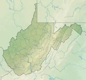 Location of Sappingtons Run mouth  Sappingtons Run (the United States) | |
| Location | |
| Country | United States |
| State | West Virginia |
| County | Brooke |
| Physical characteristics | |
| Source | unnamed tributary to Harmon Creek divide |
| • location | about 2 miles west of Colliers, West Virginia |
| • coordinates | 40°22′09″N 080°34′21″W / 40.36917°N 80.57250°W[1] |
| • elevation | 1.140 ft (0.347 m)[2] |
| Mouth | Harmon Creek |
• location | Weirton, West Virginia |
• coordinates | 40°23′23″N 080°34′07″W / 40.38972°N 80.56861°W[1] |
• elevation | 725 ft (221 m)[3] |
| Length | 2.31 mi (3.72 km)[4] |
| Basin size | 2.08 square miles (5.4 km2)[5] |
| Discharge | |
| • location | Harmons Creek |
| • average | 2.40 cu ft/s (0.068 m3/s) at mouth with Harmon Creek[5] |
| Basin features | |
| Progression | Harmon Creek → Ohio River → Mississippi River → Gulf of Mexico |
| River system | Ohio River |
| Tributaries | |
| • left | unnamed tributaties |
| • right | unnamed tributaries |
| Bridges | Morton Hill Road, WV 1, Three Arches Road |
Sappingtons Run is a 2.31 mi (3.72 km) long 1st order tributary to Harmon Creek in Brooke County, West Virginia. This is the only stream of this name in the United States.[1]
Course
Sappingtons Run rises about 2 miles west of Colliers, West Virginia, and then flows north and northeast to join Harmon Creek at Weirton.[3]
Watershed
Sappingtons Run drains 2.08 square miles (5.4 km2) of area, receives about 40.1 in/year of precipitation, has a wetness index of 300.63, and is about 76% forested.[5]
See also
References
- 1 2 3 "GNIS Detail - Sappingtons Run". geonames.usgs.gov. US Geological Survey. Retrieved 7 June 2021.
- ↑ "Get Maps". USGS Topoview. US Geological Survey. Retrieved 7 June 2021.
- 1 2 "Get Maps". USGS Topoview. US Geological Survey. Retrieved 7 June 2021.
- ↑ "ArcGIS Web Application". epa.maps.arcgis.com. US EPA. Retrieved 7 June 2021.
- 1 2 3 "Sappingtons Run Watershed Report". US EPA Geoviewer. US EPA. Retrieved 7 June 2021.
This article is issued from Wikipedia. The text is licensed under Creative Commons - Attribution - Sharealike. Additional terms may apply for the media files.