Sainte-Cérotte | |
|---|---|
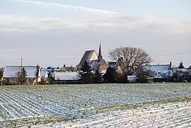 The village in the snow | |
.svg.png.webp) Coat of arms | |
Location of Sainte-Cérotte | |
 Sainte-Cérotte 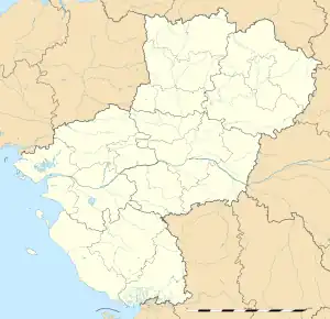 Sainte-Cérotte | |
| Coordinates: 47°54′04″N 0°41′13″E / 47.901°N 0.687°E | |
| Country | France |
| Region | Pays de la Loire |
| Department | Sarthe |
| Arrondissement | Mamers |
| Canton | Saint-Calais |
| Intercommunality | Vallées de la Braye et de l'Anille |
| Government | |
| • Mayor (2020–2026) | Yves Foucault[1] |
| Area 1 | 14.36 km2 (5.54 sq mi) |
| Population | 316 |
| • Density | 22/km2 (57/sq mi) |
| Demonym(s) | Cérottois, Cérottoise |
| Time zone | UTC+01:00 (CET) |
| • Summer (DST) | UTC+02:00 (CEST) |
| INSEE/Postal code | 72272 /72120 |
| Elevation | 104–167 m (341–548 ft) |
| 1 French Land Register data, which excludes lakes, ponds, glaciers > 1 km2 (0.386 sq mi or 247 acres) and river estuaries. | |
Sainte-Cérotte (French pronunciation: [sɛ̃t seʁɔt]) is a commune in the Sarthe department in the region of Pays de la Loire in north-western France.
See also
References
- ↑ "Répertoire national des élus: les maires". data.gouv.fr, Plateforme ouverte des données publiques françaises (in French). 2 December 2020.
- ↑ "Populations légales 2020". The National Institute of Statistics and Economic Studies. 29 December 2022.
Wikimedia Commons has media related to Sainte-Cérotte.
This article is issued from Wikipedia. The text is licensed under Creative Commons - Attribution - Sharealike. Additional terms may apply for the media files.