Saint-Jean-d'Ataux | |
|---|---|
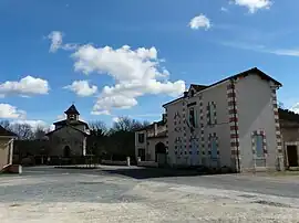 The town hall and church in Saint-Jean-d'Ataux | |
Location of Saint-Jean-d'Ataux | |
 Saint-Jean-d'Ataux  Saint-Jean-d'Ataux | |
| Coordinates: 45°08′37″N 0°24′38″E / 45.1436°N 0.4106°E | |
| Country | France |
| Region | Nouvelle-Aquitaine |
| Department | Dordogne |
| Arrondissement | Périgueux |
| Canton | Vallée de l'Isle |
| Government | |
| • Mayor (2020–2026) | Jean-Michel Sébastien[1] |
| Area 1 | 12.11 km2 (4.68 sq mi) |
| Population | 133 |
| • Density | 11/km2 (28/sq mi) |
| Time zone | UTC+01:00 (CET) |
| • Summer (DST) | UTC+02:00 (CEST) |
| INSEE/Postal code | 24424 /24190 |
| Elevation | 71–157 m (233–515 ft) |
| 1 French Land Register data, which excludes lakes, ponds, glaciers > 1 km2 (0.386 sq mi or 247 acres) and river estuaries. | |
Saint-Jean-d'Ataux (French pronunciation: [sɛ̃ ʒɑ̃ dato]; Limousin: Sent Joan d'Astaus) is a commune in the Dordogne department in Nouvelle-Aquitaine in southwestern France.
Population
| Year | Pop. | ±% |
|---|---|---|
| 1962 | 131 | — |
| 1968 | 119 | −9.2% |
| 1975 | 94 | −21.0% |
| 1982 | 127 | +35.1% |
| 1990 | 136 | +7.1% |
| 1999 | 150 | +10.3% |
| 2008 | 119 | −20.7% |
See also
References
- ↑ "Répertoire national des élus: les maires". data.gouv.fr, Plateforme ouverte des données publiques françaises (in French). 2 December 2020.
- ↑ "Populations légales 2020". The National Institute of Statistics and Economic Studies. 29 December 2022.
Wikimedia Commons has media related to Saint-Jean-d'Ataux.
This article is issued from Wikipedia. The text is licensed under Creative Commons - Attribution - Sharealike. Additional terms may apply for the media files.