Biron | |
|---|---|
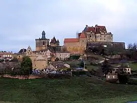 A general view of Biron | |
.svg.png.webp) Coat of arms | |
Location of Biron | |
 Biron  Biron | |
| Coordinates: 44°37′54″N 0°52′23″E / 44.6317°N 0.8731°E | |
| Country | France |
| Region | Nouvelle-Aquitaine |
| Department | Dordogne |
| Arrondissement | Bergerac |
| Canton | Lalinde |
| Government | |
| • Mayor (2020–2026) | Bruno Desmaison[1] |
| Area 1 | 12.98 km2 (5.01 sq mi) |
| Population | 142 |
| • Density | 11/km2 (28/sq mi) |
| Time zone | UTC+01:00 (CET) |
| • Summer (DST) | UTC+02:00 (CEST) |
| INSEE/Postal code | 24043 /24540 |
| Elevation | 128–240 m (420–787 ft) (avg. 200 m or 660 ft) |
| 1 French Land Register data, which excludes lakes, ponds, glaciers > 1 km2 (0.386 sq mi or 247 acres) and river estuaries. | |
Biron (French pronunciation: [biʁɔ̃]; Occitan: Biront) is a commune in the Dordogne department in southwestern France.
Geography
Biron lies between the Dropt and Lède rivers between the towns of Monpazier, Villeréal and Villefranche-du-Périgord.
Population
| Year | Pop. | ±% |
|---|---|---|
| 1864 | 555 | — |
| 1962 | 122 | −78.0% |
| 1968 | 123 | +0.8% |
| 1975 | 121 | −1.6% |
| 1982 | 120 | −0.8% |
| 1990 | 132 | +10.0% |
| 1999 | 140 | +6.1% |
| 2008 | 183 | +30.7% |
Sights
Biron is dominated by the Château de Biron, which overlooks the village and was a bastion in medieval times. Today the château is a tourist hotspot in the summer months.
See also
References
- ↑ "Répertoire national des élus: les maires". data.gouv.fr, Plateforme ouverte des données publiques françaises (in French). 2 December 2020.
- ↑ "Populations légales 2020". The National Institute of Statistics and Economic Studies. 29 December 2022.
External links
Wikimedia Commons has media related to Biron (Dordogne).
This article is issued from Wikipedia. The text is licensed under Creative Commons - Attribution - Sharealike. Additional terms may apply for the media files.