Saint-Benoît-la-Chipotte | |
|---|---|
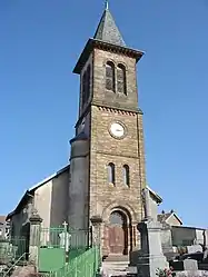 The church in Saint-Benoît-la-Chipotte | |
Location of Saint-Benoît-la-Chipotte | |
 Saint-Benoît-la-Chipotte 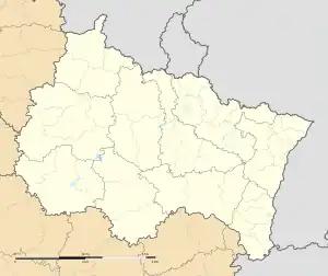 Saint-Benoît-la-Chipotte | |
| Coordinates: 48°21′30″N 6°44′08″E / 48.3583°N 6.7356°E | |
| Country | France |
| Region | Grand Est |
| Department | Vosges |
| Arrondissement | Épinal |
| Canton | Raon-l'Étape |
| Intercommunality | CC Région de Rambervillers |
| Government | |
| • Mayor (2020–2026) | Céline Tanneur[1] |
| Area 1 | 20.77 km2 (8.02 sq mi) |
| Population | 449 |
| • Density | 22/km2 (56/sq mi) |
| Time zone | UTC+01:00 (CET) |
| • Summer (DST) | UTC+02:00 (CEST) |
| INSEE/Postal code | 88412 /88700 |
| Elevation | 324–524 m (1,063–1,719 ft) (avg. 340 m or 1,120 ft) |
| 1 French Land Register data, which excludes lakes, ponds, glaciers > 1 km2 (0.386 sq mi or 247 acres) and river estuaries. | |
Saint-Benoît-la-Chipotte (French pronunciation: [sɛ̃ bənwa la ʃipɔt] ⓘ) is a commune in the Vosges department in Grand Est in northeastern France.
See also
References
- ↑ "Répertoire national des élus: les maires". data.gouv.fr, Plateforme ouverte des données publiques françaises (in French). 9 August 2021.
- ↑ "Populations légales 2020". The National Institute of Statistics and Economic Studies. 29 December 2022.
Wikimedia Commons has media related to Saint-Benoît-la-Chipotte.
This article is issued from Wikipedia. The text is licensed under Creative Commons - Attribution - Sharealike. Additional terms may apply for the media files.