Rosewood, Kentucky | |
|---|---|
 Rosewood  Rosewood | |
| Coordinates: 37°5′12″N 87°5′22″W / 37.08667°N 87.08944°W | |
| Country | United States |
| State | Kentucky |
| County | Muhlenberg |
| Elevation | 600 ft (200 m) |
| Time zone | UTC-6 (Central (CST)) |
| • Summer (DST) | UTC-5 (CST) |
| GNIS feature ID | 502355[1] |
Rosewood is an unincorporated community located in Muhlenberg County, Kentucky, United States.
History
The community was named for the abundance of rosewood.[2]
Geography
The community is located along Kentucky Route 973 in southern Muhlenberg County.
In popular culture
Rosewood, along with other rural towns in Kentucky such as Muldraugh, West Point, and Riverside are the main setting of the open world survival horror game Project Zomboid.
Notable people
- Merle Travis, country singer and guitarist.
References
- ↑ U.S. Geological Survey Geographic Names Information System: Rosewood, Kentucky
- ↑ Anderson, Bobby (September 19, 2007). "Sandy Called These Names". Leader-News. pp. A12. Retrieved May 16, 2015.
Municipalities and communities of Muhlenberg County, Kentucky, United States | ||
|---|---|---|
| Cities | 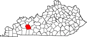 Location of Muhlenberg County, Kentucky | |
| CDPs | ||
| Other communities | ||
| Ghost town | ||
| Footnotes | ‡This populated place also has portions in an adjacent county or counties | |
This article is issued from Wikipedia. The text is licensed under Creative Commons - Attribution - Sharealike. Additional terms may apply for the media files.