Raufarhöfn | |
|---|---|
Village | |
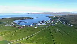 Raufarhöfn seen from the air | |
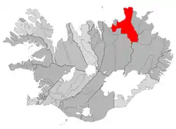 Location of the Municipality of Norðurþing | |
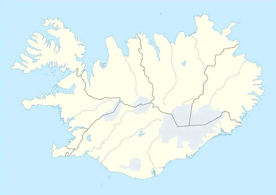 Raufarhöfn Location of Raufarhöfn in Iceland | |
| Coordinates: 66°27′15″N 15°57′00″W / 66.45417°N 15.95000°W | |
| Country | |
| Constituency | Northeast Constituency |
| Region | Northeastern Region |
| Municipality | Norðurþing |
| Population (2019) | |
| • Total | 188 |
| Time zone | UTC+0 (GMT) |
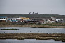
Raufarhöfn (Icelandic pronunciation: [ˈrœyːvarˌhœpn̥]) is a village located on the northeastern tip of the Melrakkaslétta [ˈmɛlˌrahkaˌstljɛhta] peninsula in Iceland.
History
At one point in time, this small village was home to largest export harbor in Iceland. In the forties and fifties, the herring frenzy dominated the Icelandic economy[1] and Raufarhöfn was an important place in that economic chain. But after the herring were fished out, the effect was devastating for the village. As of 2019, it had 188[2] inhabitants.
The village is also the site of a modern monument called the "Arctic Henge" which is aligned to the heavens and is inspired by the mythical world of the Eddic poem Völuspá (Prophecy of the Seeress).[3]
Sights
The church was built in 1928 by Guðjón Samúelsson, one of the most important Icelandic architects, and inaugurated on 1 January 1929.[4] It was renovated in 1979.[5] Circa 1996, a large stone monument, "Arctic Henge" (Heimskautsgerði [ˈheimˌskœytsˌcɛrðɪ] in Icelandic), was constructed close to the village.[6] Inspired by historic stone circles as of 2021 the site is still under construction.[7]
Climate
The climate is tundra (Koppen: ET). As the northernmost community of mainland Iceland, Raufarhöfn is also the coldest with an annual average of 2.0 °C.[8]
| Climate data for Raufarhöfn (1961–1990) | |||||||||||||
|---|---|---|---|---|---|---|---|---|---|---|---|---|---|
| Month | Jan | Feb | Mar | Apr | May | Jun | Jul | Aug | Sep | Oct | Nov | Dec | Year |
| Record high °C (°F) | 10.3 (50.5) |
11.0 (51.8) |
12.7 (54.9) |
17.0 (62.6) |
20.8 (69.4) |
24.0 (75.2) |
23.0 (73.4) |
24.7 (76.5) |
21.7 (71.1) |
17.2 (63.0) |
14.8 (58.6) |
10.6 (51.1) |
24.7 (76.5) |
| Average high °C (°F) | 0.4 (32.7) |
0.8 (33.4) |
0.6 (33.1) |
2.8 (37.0) |
5.8 (42.4) |
9.3 (48.7) |
10.9 (51.6) |
10.8 (51.4) |
8.0 (46.4) |
5.1 (41.2) |
1.9 (35.4) |
0.8 (33.4) |
4.8 (40.6) |
| Daily mean °C (°F) | −2.2 (28.0) |
−1.9 (28.6) |
−2.2 (28.0) |
−0.2 (31.6) |
2.9 (37.2) |
6.4 (43.5) |
8.0 (46.4) |
8.0 (46.4) |
5.3 (41.5) |
2.6 (36.7) |
−0.6 (30.9) |
−2.0 (28.4) |
2.0 (35.6) |
| Average low °C (°F) | −5.0 (23.0) |
−4.6 (23.7) |
−4.9 (23.2) |
−2.8 (27.0) |
0.5 (32.9) |
4.0 (39.2) |
5.7 (42.3) |
5.7 (42.3) |
2.8 (37.0) |
0.2 (32.4) |
−3.3 (26.1) |
−4.9 (23.2) |
−0.6 (30.9) |
| Record low °C (°F) | −21.5 (−6.7) |
−21.2 (−6.2) |
−24.6 (−12.3) |
−21.8 (−7.2) |
−16.0 (3.2) |
−3.7 (25.3) |
−2.3 (27.9) |
−2.2 (28.0) |
−6.0 (21.2) |
−11.2 (11.8) |
−17.9 (−0.2) |
−17.9 (−0.2) |
−24.6 (−12.3) |
| Average precipitation mm (inches) | 76 (3.0) |
57 (2.2) |
66 (2.6) |
47 (1.9) |
28 (1.1) |
39 (1.5) |
48 (1.9) |
58 (2.3) |
73 (2.9) |
86 (3.4) |
80 (3.1) |
76.5 (3.01) |
733 (28.9) |
| Mean monthly sunshine hours | 5.2 | 25.7 | 47.5 | 75.7 | 108.2 | 113.5 | 96.2 | 90.2 | 57.7 | 31.6 | 9.5 | 0.1 | 661.1 |
| Source: Vedur.is[8] | |||||||||||||
See also
References
- ↑ "History in short".
- ↑ https://www.statice.is/statistics/population/inhabitants/municipalities-and-urban-nuclei/ zipcode 675, in March 2019.
- ↑ Nemiroff, R.; Bonnell, J., eds. (30 April 2012). "Aurora Over Raufarhöfn". Astronomy Picture of the Day. NASA. Retrieved 30 April 2012.
- ↑ http://kirkjukort.net/kirkjur/raufarhafnarkirkja_0385.html
- ↑ "Raufarhöfn the tiny northern most village in Iceland". 27 November 2021.
- ↑ "Arctic Henge".
- ↑ "The Arctic Henge". Atlas Obscura. Retrieved 29 October 2022.
- 1 2 "Climate data for Raufarhöfn". vedur.is.