Raimondi District
Distrito de Raimondi | |
|---|---|
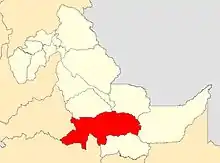 Location of Raymondi in the Atalaya province | |
| Coordinates: 10°43′59″S 73°45′02″W / 10.7331°S 73.7506°W | |
| Country | |
| Region | Ucayali |
| Province | Atalaya |
| Founded | July 2, 1943 |
| Capital | Atalaya |
| Government | |
| • Mayor | Francisco de Asís Mendoza De Souza |
| Area | |
| • Total | 14,508.51 km2 (5,601.77 sq mi) |
| Elevation | 240 m (790 ft) |
| Population | |
| • Total | 24,982 |
| • Density | 1.7/km2 (4.5/sq mi) |
| Time zone | UTC-5 (PET) |
| Website | muniatalaya.gob.pe |
Raimondi is a district in the middle Atalaya Province in Peru. Part of the Gran Pajonal, an elevated plateau occupied primarily by the Asháninka people. is in Raimondi district.
External links
- (in Spanish) Municipalidad Provincial de Atalaya
- (in Spanish) Selva amazónicas
| |
|---|---|
| Atalaya | |
| Coronel Portillo | |
| Padre Abad | |
| Purús | |
This article is issued from Wikipedia. The text is licensed under Creative Commons - Attribution - Sharealike. Additional terms may apply for the media files.