Radley, Kansas | |
|---|---|
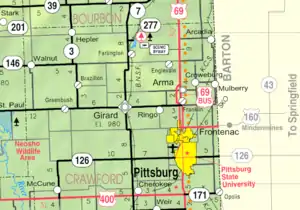 KDOT map of Crawford County (legend) | |
 Radley  Radley | |
| Coordinates: 37°29′05″N 94°45′37″W / 37.48472°N 94.76028°W[1] | |
| Country | United States |
| State | Kansas |
| County | Crawford |
| Elevation | 978 ft (298 m) |
| Population | |
| • Total | 105 |
| Time zone | UTC-6 (CST) |
| • Summer (DST) | UTC-5 (CDT) |
| Area code | 620 |
| FIPS code | 20-58325 |
| GNIS ID | 2806547[1] |
Radley is an unincorporated community in Crawford County, Kansas, United States.[1] As of the 2020 census, the population of the community and nearby areas was 105.[2]
History
A post office was opened in Radley in 1913, and remained in operation until it was discontinued in 1988.[3]
Demographics
| Census | Pop. | Note | %± |
|---|---|---|---|
| 2020 | 105 | — | |
| U.S. Decennial Census | |||
For statistical purposes, the United States Census Bureau has defined Radley as a census-designated place (CDP).
References
- 1 2 3 4 U.S. Geological Survey Geographic Names Information System: Radley, Kansas
- 1 2 "Profile of Radley, Kansas (CDP) in 2020". United States Census Bureau. Archived from the original on November 18, 2021. Retrieved November 17, 2021.
- ↑ "Kansas Post Offices, 1828-1961, page 2 (archived)". Kansas Historical Society. Archived from the original on October 9, 2013. Retrieved June 6, 2014.
Further reading
External links
Municipalities and communities of Crawford County, Kansas, United States | ||
|---|---|---|
| Cities | 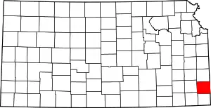 Map of Kansas highlighting Crawford County | |
| Unincorporated communities | ||
| Townships | ||
| Footnotes | †This community is designated a Census-Designated Place (CDP) by the United States Census Bureau. ‡This community also has portions in an adjacent county or counties. | |
This article is issued from Wikipedia. The text is licensed under Creative Commons - Attribution - Sharealike. Additional terms may apply for the media files.