ကြိုဆိုပါတယ်။ / Welcome to the Myanmar Portal 
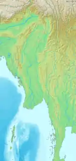
Myanmar (Burmese: မြန်မာ; MLCTS: mranma, pronounced [mjàɴ.mà]), officially the Republic of the Union of Myanmar, also known as Burma (the official name until 1989), is a country in Southeast Asia. It is the largest country by area in Mainland Southeast Asia and has a population of about 55 million. It is bordered by Bangladesh and India to its northwest, China to its northeast, Laos and Thailand to its east and southeast, and the Andaman Sea and the Bay of Bengal to its south and southwest. The country's capital city is Naypyidaw, and its largest city is Yangon (formerly Rangoon).
Myanmar is a member of the East Asia Summit, Non-Aligned Movement, ASEAN, and BIMSTEC, but it is not a member of the Commonwealth of Nations despite once being part of the British Empire. Myanmar is a Dialogue Partner of the Shanghai Cooperation Organization. The country is very rich in natural resources, such as jade, gems, oil, natural gas, teak and other minerals, as well as also endowed with renewable energy, having the highest solar power potential compared to other countries of the Great Mekong Subregion. However, Myanmar has long suffered from instability, factional violence, corruption, poor infrastructure, as well as a long history of colonial exploitation with little regard to human development. In 2013, its GDP (nominal) stood at US$56.7 billion and its GDP (PPP) at US$221.5 billion. The income gap in Myanmar is among the widest in the world, as a large proportion of the economy is controlled by cronies of the military junta. Myanmar is one of the least developed countries; as of 2020, according to the Human Development Index, it ranks 147 out of 189 countries in terms of human development, the lowest in Southeast Asia. Since 2021, more than 600,000 people were displaced across Myanmar due to the surge in violence post-coup, with more than 3 million people in dire need of humanitarian assistance. (Full article...)
Selected articles -
 The history of Myanmar (also known as Burma; Burmese: မြန်မာ့သမိုင်း) covers the period from the time of first-known human settlements 13,000 years ago to the present day. The earliest inhabitants of recorded history were a Tibeto-Burman-speaking people who established the Pyu city-states ranged as far south as Pyay and adopted Theravada Buddhism.
Another group, the Bamar people, entered the upper Irrawaddy valley in the early 9th century. They went on to establish the Pagan Kingdom (1044–1297), the first-ever unification of the Irrawaddy valley and its periphery. The Burmese language and culture slowly came to replace Pyu norms during this period. After the First Mongol invasion of Burma in 1287, several small kingdoms, of which the Kingdom of Ava, the Hanthawaddy Kingdom, the Kingdom of Mrauk U and the Shan States were principal powers, came to dominate the landscape, replete with ever-shifting alliances and constant wars. (Full article...).jpg.webp)
Inle Lake (Burmese: အင်းလေးကန်; MLCTS: ang: le: kan, [ʔɪ́ɰ̃lé kàɰ̃]), a freshwater lake located in the Nyaungshwe Township of Shan State, part of Shan Hills in Myanmar (Burma). It is the second largest lake in Myanmar, with an estimated surface area of 44.9 square miles (116 km2), and one of the highest at an elevation of 2,900 feet (880 m). During the dry season, the average water depth is 7 feet (2.1 m), with the deepest point being 12 feet (3.7 m). During the rainy season, this can increase by 5 feet (1.5 m).
The watershed area for the lake lies to a large extent to the north and west of the lake. The lake drains through the Nam Pilu or Balu Chaung on its southern end. There is also a hot spring on its northwestern shore. (Full article...).svg.png.webp)
British rule in Burma lasted from 1885 to 1948, from the successive three Anglo-Burmese wars through the creation of Burma as a province of British India to the establishment of an independently administered colony, and finally independence. The region under British control was known as British Burma, and officially known as Burma (Burmese: မြန်မာနိုင်ငံတော်) from 1886. Various portions of Burmese territories, including Arakan and Tenasserim were annexed by the British after their victory in the First Anglo-Burmese War; Lower Burma was annexed in 1852 after the Second Anglo-Burmese War. The annexed territories were designated the minor province (a chief commissionership) of British Burma in 1862.
After the Third Anglo-Burmese War in 1885, Upper Burma was annexed, and the following year, the province of Burma in British India was created, becoming a major province (a lieutenant-governorship) in 1897. This arrangement lasted until 1937, when Burma began to be administered separately by the Burma Office under the Secretary of State for India and Burma. British rule was disrupted during the Japanese occupation of much of the country during World War II. Burma achieved independence from British rule on 4th January 1948. (Full article...)
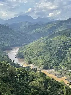
The Salween is a Southeast Asian river, about 3,289 kilometres (2,044 mi) long, flowing from the Tibetan Plateau south into the Andaman Sea. The Salween flows primarily within southwest China and eastern Myanmar (Burma), with a short section forming the border of Burma and Thailand. Throughout most of its course, it runs swiftly through rugged mountain canyons. Despite the river's great length, only the last 90 km (56 mi) are navigable, where it forms a modest estuary and delta at Mawlamyine. The river is known by various names along its course, including Thanlwin (named after Elaeocarpus sp., an olive-like plant that grows on its banks) in Burma and Nu Jiang (or Nu River, named after Nu people) in China. The commonly used spelling "Salween" is an anglicisation of the Burmese name dating from 19th-century British maps.
Due to its great range of elevation and latitude coupled with geographic isolation, the Salween basin is considered one of the most ecologically diverse regions in the world, containing an estimated 25 percent of the world's terrestrial animal species and thousands of plant species. Along its course the Salween provides water for agriculture and supports abundant fisheries, especially in the delta region. The Salween basin is home to numerous ethnic minority groups, whose ancestors largely originated in the Tibetan Plateau and northwest China. Starting about 5,000 years ago, people began migrating south along the river, establishing small kingdoms and city-states. (Full article...)
Lake of No Return (Naung Yang in Tai languages) is a body of water in Myanmar, lying in the area of the Pangsau Pass (3727') on the India–Myanmar border south of Pangsau (also called Pansaung) village. The lake is 1.4 km in length and 0.8 km in width at its widest part. It is located 2.5 km to the southwest of the Ledo Road, formerly called Stilwell Road, the road the Western Allies started building in 1942 to supply the Chinese armies of Chiang Kai-shek.
The area is home to the Tangsa community. Since the improvement of relations between India and Myanmar , the lake has come to play a part in the development of tourism in the nearby Indian Changlang District, which borders on Myanmar. (Full article...)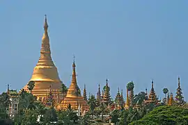
Yangon (formerly romanized as Rangoon, Burmese: ရန်ကုန်; pronounced [jàɰ̃.ɡòʊɰ̃] ) is the capital of the Yangon Region and the largest city of Myanmar (also known as Burma). Yangon served as the capital of Myanmar until 2006, when the military government relocated the administrative functions to the purpose-built capital city of Naypyidaw in north central Myanmar. With over seven million people, Yangon is Myanmar's most populous city and its most important commercial centre.
Yangon boasts the largest number of colonial-era buildings in Southeast Asia, and has a unique colonial-era urban core that is remarkably intact. The colonial-era commercial core is centered around the Sule Pagoda, which is reputed to be over 2,000 years old. The city is also home to the gilded Shwedagon Pagoda – Myanmar's most sacred and famous Buddhist pagoda. (Full article...)
The Myanmar civil war, also called the Myanmar Spring Revolution and the People's Defensive War, is an ongoing civil war following Myanmar's long-running insurgencies which escalated significantly in response to the 2021 military coup d'état and the subsequent violent crackdown on anti-coup protests.
In the months following the coup, the opposition began to coalesce around the National Unity Government, which launched an offensive against the State Administration Council (SAC), the military junta. By 2022, the opposition controlled substantial, though sparsely populated, territory. In many villages and towns, the junta's attacks drove out tens of thousands of people. On the second anniversary of the coup, in February 2023, the chairman of the SAC, Min Aung Hlaing, admitted to losing stable control over "more than a third" of townships. Independent observers note the real number is likely far higher, with as few as 72 out of 330 townships remaining under the control of the Tatmadaw, the military forces aligned with the junta. However, the townships under the control of the junta include all major population centres. (Full article...)
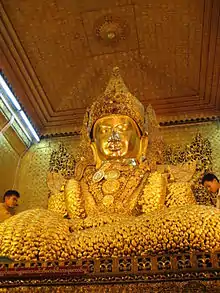
The Mahamuni Buddha Temple (Burmese: မဟာမုနိရှင်တော်မြတ်ကြီး, Burmese pronunciation: [məhà mṵnḭ pʰəjádʑí]) is a Buddhist temple and major pilgrimage site, located southwest of Mandalay, Myanmar (Burma). The Mahamuni Image (lit. 'The Great Sage') is enshrined in this temple, and originally came from Arakan. It is highly venerated in Burma and central to many people's lives, as it is seen as an expression of representing the Buddha's life.
Ancient tradition refers to only five likenesses of the Buddha made during his lifetime; two were in India, two in paradise, and the fifth is the Mahamuni Image in Myanmar. Legend holds that the Buddha himself visited the Dhanyawadi city of Arakan in 554 BC. King Sanda Thuriya requested that an image be cast of him. Once complete, the Buddha breathed upon it, and thereafter the image took on his exact likeness. (Full article...)
Thura Ma Chit Po (Burmese: သူရ မချစ်ပို; February 1908 – 8 April 1949) was a Burmese woman who was the one and only civilian woman to have received the Thura medal for bravery. She gathered intelligence on the Karen National Defence Organisation (KNDO) on behalf of the Myanmar Military before she was caught and executed by the KNDO insurgents. (Full article...)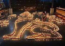
The Thadingyut Festival (Burmese: သီတင်းကျွတ်ပွဲတော်), also known as the Lighting Festival of Myanmar, is held on the full moon day of the Burmese lunar month of Thadingyut. As a custom, it is held at the end of the Buddhist sabbath (Vassa) and is the second most popular festival in Myanmar after Thingyan Festival (New Year Water Festival). Thadingyut festival is the celebration to welcome the Buddha’s descent from the heaven after he preached the Abhidhamma to his mother, Maya, who was reborn in the heaven. (Full article...)

_townships_map.svg.png.webp)
Did you know (auto-generated) -
- ... that the mission of the United Nations special envoy on Myanmar has been called a "diplomatic graveyard"?
- ... that Rolling Stone named Mission of Burma's "Academy Fight Song" as one of the 100 greatest debut singles of all time?
- ... that the Myanmar Coast Guard was initially proposed as a civilian law enforcement agency before being established as a branch of the military three years later?
- ... that Maw Htun Aung, a Shan Nationalities League for Democracy candidate in the 2020 Myanmar general election, is Kachin, not Shan?
- ... that former Burmese actress Honey Nway Oo turned rebel and took up arms against the military junta following the 2021 Myanmar coup d'état?
- ... that the EMER-K1 was created by Myanmar by reverse-engineering QBZ-97 assault rifles sold to them?
- ... that clashes between the Myanmar military and local armed groups broke out in Lay Kay Kaw six years after it was established as a "town of peace" between the parties?
- ... that the talabaw soup, which consists primarily of bamboo shoots, is the essential dish of Myanmar's Karen people, who use it to supplement rice?
Related portals and projects
Southeast Asia
Other Countries
![]() WikiProject Myanmar
WikiProject Myanmar
![]() WikiProject Southeast Asia
WikiProject Southeast Asia
![]() WikiProject Asia
WikiProject Asia
General images -
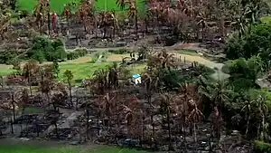 Aerial view of a burned Rohingya village in Rakhine state, Myanmar, September 2017 (from History of Myanmar)
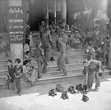 British soldiers remove their shoes at the entrance of Shwedagon Pagoda. To the left, a sign reads "Foot wearing is strictly prohibited" in Burmese, English, Tamil, and Urdu. (from Culture of Myanmar)
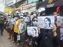 Protesters in Yangon carrying signs reading "Free Daw Aung San Suu Kyi" on 8 February 2021. (from History of Myanmar)
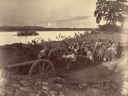 British soldiers dismantling cannons belonging to King Thibaw's forces, Third Anglo-Burmese War, Ava, 27 November 1885. Photographer: Hooper, Willoughby Wallace (1837–1912). (from History of Myanmar)
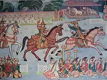 Myinhkin thabin - equestrian sport (from Culture of Myanmar)
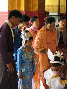
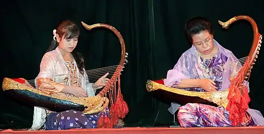 Two female musicians play the saung at a performance in Mandalay. (from Culture of Myanmar)
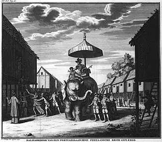 Portuguese ruler and soldiers mounting an Elephant. Philips, Jan Caspar (draughtsman and engraver) (from History of Myanmar)
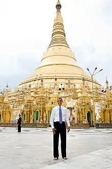 Former US President Barack Obama poses barefoot on the grounds of Shwedagon Pagoda, one of Myanmar's major Buddhist pilgrimage sites. (from Culture of Myanmar)
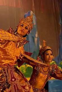 A theatrical performance of the Mon dance (from Culture of Myanmar)
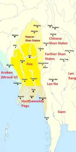 Political Map of Burma (Myanmar) c. 1450 CE. (from History of Myanmar)
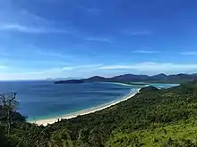 Grandfather Island, Dawei (from Geography of Myanmar)
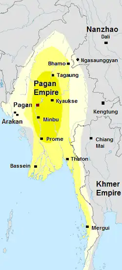 Pagan Kingdom during Narapatisithu's reign. Burmese chronicles also claim Kengtung and Chiang Mai. Core areas shown in darker yellow. Peripheral areas in light yellow. Pagan incorporated key ports of Lower Burma into its core administration by the 13th century. (from History of Myanmar)
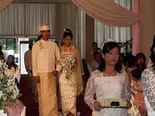 A wedding procession, with the groom and bride dressed in traditional Burmese wedding clothes, reminiscent of royal attire. (from Culture of Myanmar)
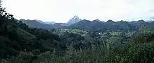 Mountains near Pindaya on the Shan Plateau (from Geography of Myanmar)
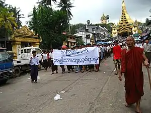 Protesters in Yangon with a banner that reads non-violence: national movement in Burmese, in the background is Shwedagon Pagoda. (from History of Myanmar)
 Temples at Mrauk U, was the capital of the Mrauk U Kingdom, which ruled over what is now Rakhine State. (from History of Myanmar)
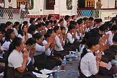 A group of Buddhist worshipers at Shwedagon Pagoda, an important religious site for Burmese Buddhists. (from Culture of Myanmar)
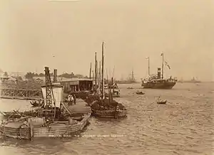 The paddle steamer Ramapoora (right) of the British India Steam Navigation Company on the Rangoon river having just arrived from Moulmein. 1895. Photographers: Watts and Skeen (from History of Myanmar)
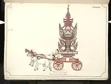 19th century funeral cart and spire, which would form part of the procession from the home to the place of cremation (from Culture of Myanmar)
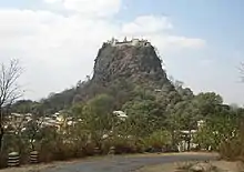 Mount Popa, a dormant volcano in the Central Lowlands (from Geography of Myanmar)
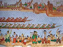 Hlei pyaingbwè - a Burmese regatta (from Culture of Myanmar)
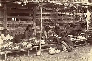 Vegetable stall on the roadside at the Madras Lancer Lines, Mandalay, January 1886. Photographer: Hooper, Willoughby Wallace (1837–1912). (from History of Myanmar)
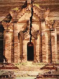 A large fracture on the Mingun Pahtodawgyi caused by the 1839 Ava earthquake. (from Geography of Myanmar)
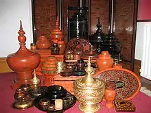 A wide range of Burmese lacquerware from Bagan (from Culture of Myanmar)
 Sculpture of Myanmar mythical lion (from Culture of Myanmar)
 Saint Mary's Cathedral in Downtown Yangon is the largest Roman Catholic cathedral in Burma. (from Culture of Myanmar)
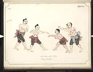 Boxing match. 19th-century watercolour (from Culture of Myanmar)
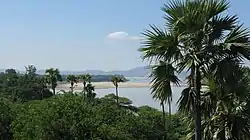 The shores of Irrawaddy River at Nyaung-U, Bagan (from Geography of Myanmar)
_headquarter.jpg.webp) Aung San Suu Kyi addresses crowds at the NLD headquarters shortly after her release. (from History of Myanmar)
Aung San Suu Kyi addresses crowds at the NLD headquarters shortly after her release. (from History of Myanmar) Myanmar (Burma) map of Köppen climate classification (from Geography of Myanmar)
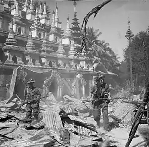 British soldiers on patrol in the ruins of the Burmese town of Bahe during the advance on Mandalay, January 1945. (from History of Myanmar)
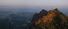
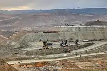 Jade Mine in Hpakant (from Geography of Myanmar)
.jpg.webp) Salween river at Mae Sam Laep on the Thai-Myanmar border (from Geography of Myanmar)
Salween river at Mae Sam Laep on the Thai-Myanmar border (from Geography of Myanmar)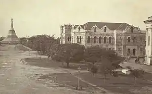 Recorder's Court on Sule Pagoda Road, with the Sule Pagoda at the far end, Rangoon, 1868. Photographer: J. Jackson. (from History of Myanmar)
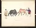 A bull fight. 19th-century watercolour (from Culture of Myanmar)
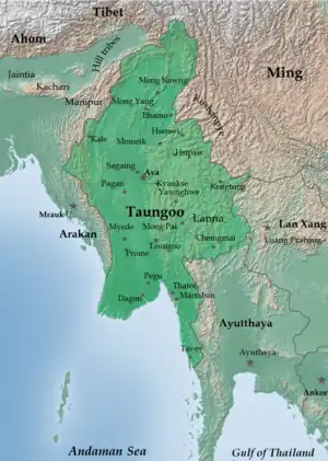 The restored Taungoo or Nyaungyan dynasty c. 1650 CE. (from History of Myanmar)
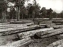
Major topics
Categories
More topics
Associated Wikimedia
The following Wikimedia Foundation sister projects provide more on this subject:
-
 Commons
Free media repository -
 Wikibooks
Free textbooks and manuals -
 Wikidata
Free knowledge base -
 Wikinews
Free-content news -
 Wikiquote
Collection of quotations -
 Wikisource
Free-content library -
 Wikiversity
Free learning tools -
 Wikivoyage
Free travel guide -
 Wiktionary
Dictionary and thesaurus
More portals
-
 List of all portalsList of all portals
 -
 The arts portal
 -
 Biography portal
 -
 Current events portal
 -
 Geography portal
 -
 History portal
 -
 Mathematics portal
 -
 Science portal
 -
 Society portal
 -
 Technology portal
 -
 Random portalRandom portal
 -
 WikiProject PortalsWikiProject Portals