| Oruanui eruption | |
|---|---|
| Volcano | Taupō Volcano |
| Date | About 25,700 year BP |
| Type | Ultra-Plinian |
| Location | North Island, New Zealand 38°48′S 175°54′E / 38.800°S 175.900°E |
| Volume | 1,170 km3 (280 cu mi) |
| VEI | 8 |
| Impact | Devastated much of North Island with detectable ash fall 5,000 km (3,100 mi) away |
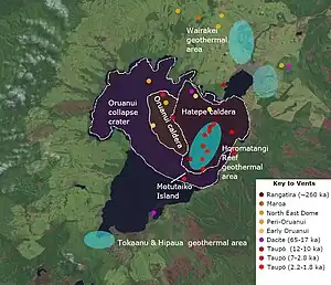 Recent vents and caldera structures Taupō Volcano. Present active geothermal systems are in light blue. A key to the vents is in the diagram. | |
The Oruanui eruption of New Zealand's Taupō Volcano (also known as the Kawakawa eruption or Kawakawa/Oruanui event) was the world's most recent supereruption,[1] and largest phreatomagmatic eruption characterised to date.[2]: 8
Eruption

With a Volcanic Explosivity Index of 8, it is one of the largest eruptions ever to occur in New Zealand. It occurred about 25675±90 years Before Present[4][5] in the Late Pleistocene and generated approximately 430 km3 (100 cu mi) of pyroclastic fall deposits, 320 km3 (77 cu mi) of pyroclastic density current (PDC) deposits (mostly ignimbrite) and 420 km3 (100 cu mi) of primary intracaldera material, equivalent to 530 km3 (130 cu mi) of rhyolitic magma, totalling 1,170 km3 (280 cu mi) of total deposits. The eruption is divided into 10 different phases on the basis of nine mappable fall units and a tenth, poorly preserved but volumetrically dominant fall unit.[6][3][7][8]
Modern-day Lake Taupō, 616 km2 (238 sq mi) in area and 186 m (610 ft) deep, partly fills the caldera generated during this eruption. A 140 km2 (54 sq mi) structural collapse is concealed beneath Lake Taupō, while the lake outline at least partly reflects volcano-tectonic collapse. Early eruption phases saw shifting vent positions; development of the caldera to its maximum extent (indicated by lithic lag breccias) occurred during phase 10.
Unusual features
The Oruanui eruption shows many unusual features: its episodic nature, a wide range of magma-water interaction, and complex interplay of pyroclastic fall and flow deposits.[6] The eruption occurred through a lake system which was either the southern section of Lake Huka,[3] or some have suggested Lake Taupō had separated with a higher level than the remaining Lake Huka about a thousand years earlier, due to eruptive activity of the Poihipi volcano whose magma chamber is under Wairakei and that had erupted at Trig 9471 and the Rubbish Tip Domes about 27,000 years ago, filling that portion of Lake Huka.[2]: Fig. 4 [9] Accordingly many of the deposits contain volcanic ash aggregates.[10]
Local impact
Tephra from the eruption covered much of the central North Island and is termed Kawakawa-Oruanui tephra, or KOT.[11] The Oruanui ignimbrite is up to 200 metres (660 ft) deep. Ashfall affected most of New Zealand, with an ash layer as thick as 18 centimetres (7 in) deposited on the Chatham Islands, 1,000 km (620 mi) away. The local biological impact must have been immense as 10 centimetres (4 in) of ash was deposited from just south of Auckland over the whole of the rest of the North Island, and the top of the South Island, both of which were larger in land area as sea levels were considerably lower. The pyroclastic ignimbrite flows destroyed all vegetation they reached.[3] Later erosion and sedimentation had long-lasting effects on the landscape and may have caused the Waikato River to shift from the Hauraki Plains to its current course through the Waikato to the Tasman Sea. Less than 22,500 years ago, Lake Taupō, having filled to about 75 m (246 ft) above its current level, and draining initially via a Waihora outlet to the northwest, cut through its Oruanui ignimbrite dam near the present Taupō outlet to the northeast at a rate which left no terraces around the lake. About 60 km3 (14 cu mi) of water was released, leaving boulders of up to 10 m (33 ft) at least as far down the Waikato River as Mangakino.[12] The impact has been summarised as:[3]
- A wholly new landscape around the caldera, with ignimbrite accumulations that were landscape-burying up to hundreds of metres thick and ponding in valleys. The actual area of the ignimbrite is less than the subsequent smaller Hatepe eruption presumably because the later generated a more intense pyroclastic flow but much less accumulative tephra fall.
- The area created by the caldera collapse acted both as a sink for sedimentation in the local catchment and as the basin in which a new Lake Taupō accumulated.
- The former Lake Huka that had extended to the north and partially occupied the older Reporoa Caldera was destroyed and filled in with ignimbrite, which also created a temporary barrier between the Taupō and Reporoa watersheds that had to be eroded before a stable drainage of the new Lake Taupō was established.
- Cumulative thicknesses of fall deposits and ignimbrite were likely sufficient to have wholly destroyed or buried vegetation over virtually all of the central North Island.
- Remobilisation of the vast quantities of pyroclastic material as alluvium produced profound changes in the drainage pattern of the Waikato River, with an impact particularly on the Waikato Plains and Hauraki Plains.
Distal impact
The Oruanui eruption ash deposits from the final (tenth) phase have been geochemically matched to Western Antarctic ice core deposits 5,000 km (3,100 mi) away and they provide a convenient marker for the last glacial maximum in Antarctica.[11] This ash cloud has been modelled to have taken about two weeks to encircle the Southern Hemisphere.[11] Diatoms from erupted lake sediments have been found in the volcanic ash deposits about 850 km (530 mi) downwind on the Chatham Islands.[13]: 2
Afterwards
The first characterised eruption from the Taupō Volcano after the Oruanui eruption took place about 5000 years later.[2]: 10 The first three eruptions were dacitic as was the Puketarata eruption.[2]: 10 The other twenty-four rhyolitic events until the present, including the major Hatepe eruption, dated to around 232 CE came from three distinct magma sources.[2]: 10 These have had geographically focussed vent locations, and a wide range of eruption volumes, with nine explosive events producing tephra deposits.[2]: 10
See also
- North Island Volcanic Plateau
- Taupō volcano
- Hatepe eruption (The most recent major eruption of the Taupō volcano)
References
- ↑ Lowe, D. J.; Balks, M. R. (2019). "Introduction to Tephra-Derived Soils and Farming, Waikato-Bay of Plenty, North Island, New Zealand" (PDF).
- 1 2 3 4 5 6 Barker, SJ; Wilson, CJN; Illsley-Kemp, F; Leonard, GS; Mestel, ERH; Mauriohooho, K; Charlier, BLA (2020). "Taupō: an overview of New Zealand's youngest supervolcano" (PDF). New Zealand Journal of Geology and Geophysics. doi:10.1080/00288306.2020.1792515. Retrieved 2023-11-28.
- 1 2 3 4 5 Manville, V.; Wilson, C. J. N. (2004). "The 26.7 ka Oruanui eruption, New Zealand: A review of the roles of volcanism and climate in the post‐eruptive sedimentary response". New Zealand Journal of Geology and Geophysics. 47 (3): 525. doi:10.1080/00288306.2004.9515074.
- ↑ Dong, Xiyu; Kathayat, Gayatri; Rasmussen, Sune O.; Svensson, Anders; Severinghaus, Jeffrey P.; Li, Hanying; Sinha, Ashish; Xu, Yao; Zhang, Haiwei; Shi, Zhengguo; Cai, Yanjun; Pérez-Mejías, Carlos; Baker, Jonathan; Zhao, Jingyao; Spötl, Christoph (2022-10-04). "Coupled atmosphere-ice-ocean dynamics during Heinrich Stadial 2". Nature Communications. 13 (1): 5867. Bibcode:2022NatCo..13.5867D. doi:10.1038/s41467-022-33583-4. ISSN 2041-1723. PMC 9532435. PMID 36195764.
- ↑ Muscheler, Raimund; Adolphi, Florian; Heaton, Timothy J; Bronk Ramsey, Christopher; Svensson, Anders; van der Plicht, Johannes; Reimer, Paula J (2020). "Testing and Improving the IntCal20 Calibration Curve with Independent Records". Radiocarbon. 62 (4): 1079–1094. Bibcode:2020Radcb..62.1079M. doi:10.1017/RDC.2020.54. ISSN 0033-8222.
- 1 2 Wilson, C. J. N. (2001). "The 26.5ka Oruanui eruption, New Zealand: An introduction and overview". Journal of Volcanology and Geothermal Research. 112 (1–4): 133–174. Bibcode:2001JVGR..112..133W. doi:10.1016/S0377-0273(01)00239-6.
- ↑ Wilson, C. J. N. (2005). "The 26.5 ka Oruanui Eruption, Taupo Volcano, New Zealand: Development, Characteristics and Evacuation of a Large Rhyolitic Magma Body". Journal of Petrology. 47: 35–69. doi:10.1093/petrology/egi066.
- ↑ Richard Smith, David J. Lowe and Ian Wright. 'Volcanoes – Lake Taupo', Te Ara – the Encyclopedia of New Zealand, updated 16 April 2007.
- ↑ Rosenberg, MD; Wilson, CJ; Bignall, G; Ireland, TR; Sepulveda, F; Charlier, BL (15 January 2020). "Structure and evolution of the Wairakei–Tauhara geothermal system (Taupo Volcanic Zone, New Zealand) revisited with a new zircon geochronology". Journal of Volcanology and Geothermal Research. 390 (106705). doi:10.1016/j.jvolgeores.2019.106705.: 6.3.3. Origins of the modern Wairakei-Tauhara geothermal system
- ↑ Van Eaton, Alexa R.; Wilson, Colin J. N. (2013). "The nature, origins and distribution of ash aggregates in a large-scale wet eruption deposit: Oruanui, New Zealand". Journal of Volcanology and Geothermal Research. 250: 129–154. Bibcode:2013JVGR..250..129V. doi:10.1016/j.jvolgeores.2012.10.016.
- 1 2 3 Dunbar, N.W.; Iverson, N.A.; Van Eaton, A.R.; Sigl, M.; Alloway, B.V.; Kurbatov, A.V.; Mastin, L.G.; McConnell, J.R.; Wilson, C.J.N. (2017). "New Zealand supereruption provides time marker for the Last Glacial Maximum in Antarctica". Scientific Reports. 7 (12238): 12238. Bibcode:2017NatSR...712238D. doi:10.1038/s41598-017-11758-0. PMC 5613013. PMID 28947829.
- ↑ Manville, V.; Hodgson, K. A.; Nairn, I. A. (June 2007). "A review of break‐out floods from volcanogenic lakes in New Zealand". New Zealand Journal of Geology and Geophysics. 50 (2): 131–150. doi:10.1080/00288300709509826. ISSN 0028-8306. S2CID 129792354.
- ↑ Harper, MA; Pledger, SA; Smith, EG; Van Eaton, AR; Wilson, CJ (2015). "Eruptive and environmental processes recorded by diatoms in volcanically dispersed lake sediments from the Taupo Volcanic Zone, New Zealand". Journal of paleolimnology. 54 (263–77): 1–15. doi:10.1007/s10933-015-9851-5.