Nordmaling Municipality
Nordmalings kommun | |
|---|---|
 | |
 Coat of arms | |
 | |
| Coordinates: 63°34′N 19°30′E / 63.567°N 19.500°E | |
| Country | Sweden |
| County | Västerbotten County |
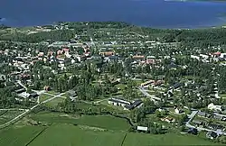
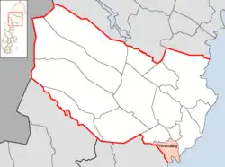
| Seat | Nordmaling |
| Area | |
| • Total | 2,472.26 km2 (954.54 sq mi) |
| • Land | 1,229.42 km2 (474.68 sq mi) |
| • Water | 1,242.84 km2 (479.86 sq mi) |
| Area as of 1 January 2014. | |
| Population (31 December 2021)[2] | |
| • Total | 7,100 |
| • Density | 2.9/km2 (7.4/sq mi) |
| Time zone | UTC+1 (CET) |
| • Summer (DST) | UTC+2 (CEST) |
| ISO 3166 code | SE |
| Province | Ångermanland |
| Municipal code | 2401 |
| Website | www.nordmaling.se |
Nordmaling Municipality (Swedish: Nordmalings kommun) is a municipality in Västerbotten County in northern Sweden. Its seat is located in Nordmaling.
History
The municipal system in Sweden was introduced in 1863 and Nordmaling Municipality was one of the entities created out of a parish. In 1914 a part of the municipality was detached. The subdivision reforms of 1952 and 1971 did not affect the municipality.
Localities
There are three localities (or urban areas) in Nordmaling Municipality:[3]
| # | Locality | Population |
|---|---|---|
| 1 | Nordmaling | 2,619 |
| 2 | Rundvik | 911 |
| 3 | Lögdeå | 414 |
The municipal seat in bold
References
- ↑ "Statistiska centralbyrån, Kommunarealer den 1 januari 2014" (in Swedish). Statistics Sweden. 2014-01-01. Archived from the original (Microsoft Excel) on 2016-09-27. Retrieved 2014-04-18.
- ↑ "Folkmängd i riket, län och kommuner 31 december 2021" (in Swedish). Statistics Sweden. February 22, 2022. Retrieved February 22, 2022.
- ↑ Statistics Sweden as of December 31, 2005
External links
 Media related to Nordmaling Municipality at Wikimedia Commons
- Nordmaling Municipality - Official site
Places adjacent to Nordmaling Municipality | ||||||||||||||||
|---|---|---|---|---|---|---|---|---|---|---|---|---|---|---|---|---|
| ||||||||||||||||
Municipalities and seats of Västerbotten County | ||
|---|---|---|
| Municipalities | ||
| Municipal seats | ||
This article is issued from Wikipedia. The text is licensed under Creative Commons - Attribution - Sharealike. Additional terms may apply for the media files.