Nibbe, Montana | |
|---|---|
 Nibbe, Montana  Nibbe, Montana | |
| Coordinates: 45°59′06″N 108°01′48″W / 45.98500°N 108.03000°W | |
| Country | United States |
| State | Montana |
| County | Yellowstone |
| Area | |
| • Total | 0.23 sq mi (0.60 km2) |
| • Land | 0.23 sq mi (0.60 km2) |
| • Water | 0.00 sq mi (0.00 km2) |
| Elevation | 2,894 ft (882 m) |
| Population (2020) | |
| • Total | 71 |
| • Density | 306.03/sq mi (118.07/km2) |
| Time zone | UTC-7 (Mountain (MST)) |
| • Summer (DST) | UTC-6 (MDT) |
| ZIP code | 59064 |
| Area code | 406 |
| GNIS feature ID | 2804323[2] |
Nibbe is a Census Designated Place located in Yellowstone County, Montana and shares a postal ZIP code with Pompey's Pillar (59064).
The elevation is 2,894 feet. Nibbe appears on the Nibbe U.S. Geological Survey Map.
History
Once a station on the Northern Pacific Railway one mile west of the geological formation Pompeys Pillar, Nibbe was established as a town in 1920 along the Yellowstone River. Nibbe was an agricultural community in the Huntley Project area and had a grain elevator and a number of small businesses. The community gradually faded away with the decline of the agricultural industry and the concentration of activities moving to larger nearby communities.
A post office was active in Nibbe until 1954.
Demographics
| Census | Pop. | Note | %± |
|---|---|---|---|
| 2020 | 71 | — | |
| U.S. Decennial Census[3] | |||
References
- ↑ "ArcGIS REST Services Directory". United States Census Bureau. Retrieved September 5, 2022.
- 1 2 U.S. Geological Survey Geographic Names Information System: Nibbe, Montana
- ↑ "Census of Population and Housing". Census.gov. Retrieved June 4, 2016.
Municipalities and communities of Yellowstone County, Montana, United States | ||
|---|---|---|
| Cities | 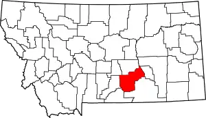 Yellowstone County map | |
| Town | ||
| CDPs | ||
| Other communities | ||
| Indian reservation | ||
| Ghost towns | ||
| Footnotes | ‡This populated place also has portions in an adjacent county or counties | |
This article is issued from Wikipedia. The text is licensed under Creative Commons - Attribution - Sharealike. Additional terms may apply for the media files.