Nea Palatia
Νέα Παλάτια | |
|---|---|
 Nea Palatia Location within the regional unit 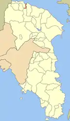 | |
| Coordinates: 38°19′N 23°47′E / 38.317°N 23.783°E | |
| Country | Greece |
| Administrative region | Attica |
| Regional unit | East Attica |
| Municipality | Oropos |
| Municipal unit | Oropioi |
| Highest elevation | 7 m (23 ft) |
| Lowest elevation | 0 m (0 ft) |
| Population (2011)[1] | |
| • Rural | 2,723 |
| Community | |
| • Population | 3,573 (2011) |
| • Area (km2) | 8.525 |
| Time zone | UTC+2 (EET) |
| • Summer (DST) | UTC+3 (EEST) |
| Postal code | 190 15 |
| Area code(s) | 22950 |
| Vehicle registration | ZB-ZY |
Nea Palatia (Greek: Νέα Παλάτια literally "New Palaces") is a community in East Attica, Greece. Since the 2011 local government reform it is part of the municipality Oropos, of which it is a community.[2] It is part of Athens metropolitan area.[3]
Geography
Nea Palatia is a seaside town, situated on the south coast of the South Euboean Gulf. The town Skala Oropou is directly adjacent to its west. It is 8 km south of Eretria (on the island Euboea). The Greek National Road 79 connects it with Motorway 1 (Athens-Thessaloniki-Evzones) near Malakasa.
Subdivisions
- Agios Konstantinos (pop. 386 in 2011)
- Nea Palatia (pop. 2,723)
- Agios Athanasios (pop. 99)
- Agia Aikaterini (pop. 57)
- Pontioi (pop. 308)
Historical population
| Year | Village population | Community population |
|---|---|---|
| 1981 | 1,894 | - |
| 1991 | 2,472 | 3,078 |
| 2001 | 2,423 | 3,647 |
| 2011 | 2,723 | 3,573 |
References
- 1 2 "Απογραφή Πληθυσμού - Κατοικιών 2011. ΜΟΝΙΜΟΣ Πληθυσμός" (in Greek). Hellenic Statistical Authority.
- ↑ "ΦΕΚ B 1292/2010, Kallikratis reform municipalities" (in Greek). Government Gazette.
- ↑ "Athens Population 2022 (Demographics, Maps, Graphs)".
External links
This article is issued from Wikipedia. The text is licensed under Creative Commons - Attribution - Sharealike. Additional terms may apply for the media files.