| Mount Echizen-dake | |
|---|---|
| Ashitaka-yama | |
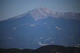 Mount Echizen from Mount Hamaishi | |
| Highest point | |
| Elevation | 1,504.22 m (4,935.1 ft) |
| Coordinates | 35°14′17″N 138°47′38.5″E / 35.23806°N 138.794028°E |
| Naming | |
| Native name | 越前岳 (Japanese) |
| Geography | |
| Location | Chūbu region, Honshu, Japan |
| Parent range | Mount Ashitaka |
| Geology | |
| Last eruption | 100000 BC |
 Echizen Mount Echizen-dake (Japan) | |
Mount Echizen-dake (越前岳, Echizendake) is a Japanese volcanic peak in the area south-east of Mount Fuji. Its summit, 1,504 meters high,[1] is located in the Susono City, Shizuoka. It is the highest peak of the Mount Ashitaka lava dome.
History
- Mount Echizen-dake erupted in the mid-Pleistocene epoch,[2] about 100,000 years ago.[3] It is an extinct volcano.[4]
- Echizen-dake was depicted on the 50-yen banknote of the 1938 issue.
Gallery
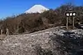 Mount Fuji from the peak
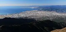 Fuji City from the peak
See also
References
- ↑ Karátson, D. "Erosion calderas: origins, processes, structural and climatic control," Bulletin of Volcanology Vol. 61 (1999), pp. 179 [PDF 6 of 20]; retrieved 2012-6-21.
- ↑ University of Tokyo, Volcano Research Center, "Geology of Fuji Volcano"; retrieved 2012-6-21.
- ↑ Kishimoto, Hiroshi et al. "Pyroclastic cone on southwestern flank of Ashikita Volcano," Japan Geoscience Union, 2010; retrieved 2012-6-21.
- ↑ Shizuoka Guide, "Overview of Mt Fuji; retrieved 2012-6-21.
The page incorporated material from Japanese Wikipedia page 越前岳, accessed 23 April 2019
External links
Wikimedia Commons has media related to Mount Echizen.
This article is issued from Wikipedia. The text is licensed under Creative Commons - Attribution - Sharealike. Additional terms may apply for the media files.