Moreh
(Meitei: /mō-rey/) | |
|---|---|
town, sub-division | |
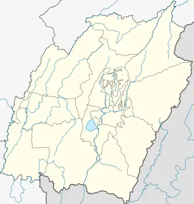 Moreh Location in Manipur, India 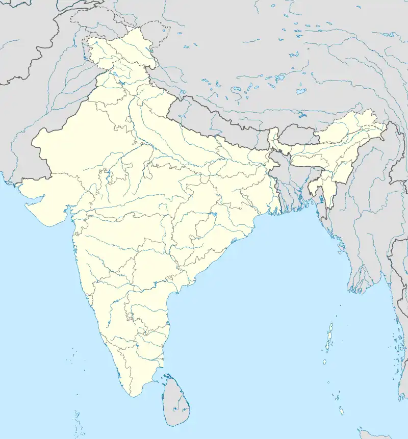 Moreh Moreh (India) | |
| Coordinates: 24°14′52″N 94°18′11″E / 24.2477°N 94.3031°E | |
| Country | |
| State | Manipur |
| District | Tengnoupal district |
| Founded by | Gambhir Singh |
| Population (2011) | |
| • Total | 16,847 |
| Language(s) | |
| • Official | Meitei (officially called Manipuri)[lower-alpha 1][1] |
| • Regional | Thadou and other Kuki-Chin languages |
| Time zone | UTC+5:30 (IST) |
| Vehicle registration | MN |
| Website | manipur |
Moreh (Meitei pronunciation: /mō-rey/[lower-alpha 1][1]) is a border town located on the India–Myanmar border in Tengnoupal district of the Indian state of Manipur.[2][3] As a rapidly developing international trade point with the integrated customs and international immigration checkpoint, Moreh plays an important role in India's Look East Policy,[4] trade and commerce under ASEAN–India Free Trade Area,[5] India-Myanmar relationship,[6] India–Myanmar–Thailand road connectivity,[7] and Trans-Asian Railway connectivity.[8][4]
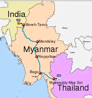
Tamu in Myanmar, just across the Menal river from Moreh, is connected to Moreh via two roads: The Indo-Myanmar Friendship Bridge and a newer Moreh ICP Bridge which connects the Moreh Integrated Check Post (Moreh ICP).[9] Tamu in Myanmar connects Moreh in India to Kalewa-Yagyi-Mandalay in Myanmar and Mae Sot in Thailand through the India–Myanmar–Thailand Trilateral Highway.[7]
History
.jpg.webp)
The 1888 Gazetteer of Manipur describes Moreh as a border post (thana) of Manipur northwest of Tamu.[10] The latter is a principal town of the Kabaw Valley, on the bank of the Lokchao River, which flows down from Manipur hills (present day Tengnoupal district) at this location. Kabaw Valley had been under the control of Manipur kingdom since the 15th century,[11] and Tamu appears to have grown up as a market town in the valley, overshadowing its previous capital Khampat.
In 1764, the Burmese emperor Alaungpaya invaded Manipur via Tamu.[12][13][14] The disposition of the Kabaw Valley after this is unclear, but the Manipur prince Marjit Singh is said to have ceded it to Burma in return for their assistance in acquiring his throne in 1813.[15] Thus, even though the next prince Gambhir Singh reoccupied the Kabaw Valley during the First Anglo-Burmese War, the British Raj returned it to Burma in 1834 as part of the post-war settlement.[16]
In the intervening period, Gambhir Singh is recorded to have "barricaded" the Lokchao gorge and established a new village in 1829.[17] The "barricade" might have been the stockade mentioned in the British Gazetteer of Manipur in 1886. Referred to as "Moreh thana", it was on the flat end of a spur that separates the Lokchao gorge from an adjacent valley to the north, where the present-day Moreh is located. This valley houses two streams called Kujierok and Lierok which unite and join the Lokchao River further downstream.[10] During the border settlement of 1834, the would-be village of Moreh was allocated to Manipur and Tamu was allocated to Burma. Another village called Namphalong later sprung up opposite Moreh on the Burmese side of the border.
A road from Lamting to Tamu, passing through Pallel and Moreh was laid in 1878.[18] Referred to as "Tamu Road"[19] or "Pallel–Moreh route", the road crossed the Lokchao River near the village of Sibong, which is thus a strategic point.[lower-alpha 2][20] In 1891, there was a palace rebellion in Manipur, and the British, who were by now in control of the whole of Burma, sent in forces stationed at Tamu to relieve the captives taken by rebels.[21] After a brief battle, Manipur was converted into a princely state of the British Empire.[22]
For most of the British Raj period, Moreh remained a mere police post.[23] Since both India and Burma were under British control, Indian traders went to Tamu and beyond to sell their goods.[24] The rise of Moreh took place during the World War II, when it was developed into an administrative and supply centre for the Allied Forces and Sibong was set up as a rear headquarters.[25] The base was held up to April 1944, when it was evacuated since the Japanese broke through in the north of the Kabaw Valley.[26] After the war, a bazar was opened at Moreh along with a police outpost, according to a Manipur Administration Report.[27]
After the independence of Burma, many Indians that had settled there during the British Raj period returned to India, some of whom settled down in Moreh. Thus Moreh acquired a cosmopolitan character with many ethnicities such as Tamils, Malayalees, Punjabis, Bengalis and Nepalese along with the local Meitei, Kuki and Naga populations. In 1988, The Telegraph described Moreh as a cosmopolitan town with 15,000 people, 80 percent of whom were expatriates from Burma. [28][29][30] Also relevant is the "Khadawmi operation" of the Burmese military government in 1967, during which Kukis that had been living in the Kabaw Valley were evicted by the Burmese as they were regarded as Indian refugees from Manipur. They settled in Moreh and the surrounding areas of Tengnoupal district. According to scholar Thongkholal Haokip, many of these Kukis had been previously displaced from the Naga-dominated ares of Manipur such as the Ukhrul district.[31][32]
Demography
Moreh is in Tengnoupal district in Manipur with a sizeable number of Tamils and other Indians. The local population includes Kuki-Zo tribals and Meiteis, with small numbers Nagas and Old Kuki/Naga people.[2][33] In the 2011 India census, Moreh had a population of 16,847. Scheduled Tribes formed 56.2% of the population and Scheduled Castes 0.2%.[35] Males were 8,670 while 8,177 were females. 14.58% of the population was under 6 years of age. The female sex ratio was 943 compared with the state average of 985. The child sex ratio was around 985 compared with the Manipur state average of 930.[35]
Languages
The predominant languages in Moreh are Thadou (a Kuki-Chin language) and Meitei (also called Manipuri). The town is multi-ethnic with other prominent languages like Hindi, Tamil, Zou, and Mizo, etc, and others. It has a substantial population of Tamils who migrated from Myanmar (Burma) when they were forced to leave during the 1962 Burmese coup d'état.[36]
Meitei and other general Indian language speakers form 42.50% of Moreh's population, the Kuki-Zo language speakers form 56.73% of the population and the remaining tribal populations constitute less than 1%.[33][lower-alpha 3]
Religion
According to 2011 Indian census the town of Moreh is a multi-religious town and the Christians getting the clear majority. there are 4,403 being Hindus, 2,354 being Muslims, 9,547 being Christians, 57 being Sikhs, 109 being Buddhists, 17 being Jains, 33 didn't specify any Religion, 327 Others.[34]
Literacy
Moreh had an average literacy rate of 71.47%,which is lower than the Manipur's average literacy rate of 76.94%: male literacy was around 79.52%,which was also lower than the state average of 76.94%. and female literacy was 62.88%, was again lower than the state average of 70.26%
Economy
Being a border trade and transit town, Moreh plays a key role in the development of the economy of the state with border haat as well as international trade. A significant portion of the economy of Moreh depends on smuggling, including illegal teak smuggled from Myanmar.[38]
Border haat
Moreh has the local Border Haat trade, under the India-Myanmar Barter Trade mechanism, in which over 40 tradable items are listed. Major exports include cement, engineering goods, transport equipment, motor cycles, iron and steels, medicine, chemicals and allied products, cotton yarn, etc. The major items now imported from Myanmar through barter mechanism are betel nuts, turmeric, red kidney beans (Rajma), kuth roots, gram, resin, dry ginger, etc.
International trade
India's Ministry of Finance has also operationalised the "normal international trade" through Moreh Integrated Check Post (Moreh ICP).[39]
Transport
India is part of BIMSTEC, East Asia Summit, Mekong-Ganga Cooperation, United Nations Economic and Social Commission for Asia and the Pacific, Asian Highway Network and the Trans-Asian Railway network and India has embarked on several Look-East connectivity projects.[40][41]
Integrated Check Post (ICP)
Moreh ICP, costing Rs. 136 crores on 18.41 hectares (45.50 acres) land near Gate No.1 within Customs notified area, facilitates speedy movement of export-import consignments under India's Look East Policy.[42] ICP has Immigration Department, Narcotics & Drug Control Department, Land Customs Department, Customs Preventive Department, Animal Quarantine, Plant Quarantine, local Police including Women Constables, Quality Certification Inspection Agencies and Export Promotion Councils, Trade Facilitation Counter and Trade related Public Bodies, Food Testing Lab, Postal Department, Forests Department, bank counter, telecom, truck parking, staff quarters, basic amenities such as canteen, truck drivers’ rest house, etc.
Airport
Imphal Airport (110 km northwest of Moreh) is the nearest airport in India. Homalin Airport (120 km north) and Kalaymyo Airport (133 km south) are the nearest airport in Myanmar.[43]
.jpg.webp)
AH1 and India-Thailand Highway
Moreh is on the Asian Highway 1 (AH1),[44] which is the longest route of the Asian Highway Network, running 20,557 km (12,774 mi) from Tokyo, Japan via Korea, China, Southeast Asia, Bangladesh, India, Pakistan, Afghanistan and Iran to the border between Turkey and Bulgaria west of Istanbul where it joins end-on with European route E80, running all the way to Lisbon, Portugal.
India–Myanmar–Thailand Trilateral Highway, 1,408 km (875 mi) long section of AH1, connects Imphal-Moreh in India with Mae Sot in Thailand via Mandalay-Kalewa-Yagyi in Myanmar.[7] It will boost India's trade and commerce with ASEAN under ASEAN–India Free Trade Area.[5][45][46][47] Imphal-Moreh route Its upgrade was already complete by 2017, however it is further being upgraded to Asian Highway Standard in 3 packages, one of which was complete and remaining two are scheduled for completion by 2023.[48] In November 2020, Bangladesh expressed interest to join this Highway.[49] India plans to upgrade route from Zokhawthar in Mizoram to Tedim in Chin State of Myanmar as an additional connect to the IMT trilateral highway.[50]
Trans-Asian Railway
Trans-Asian Railway's (TAR) Southern Corridor (also called ITI-DKD-Y), once completed, will connect Yunnan in China and Thailand with Europe via India and Turkey. As of 2021, all freight traffic from Asia to Europe goes by sea. TAR will enable containers from Singapore, China, Vietnam, Cambodia, India, Bangladesh, Myanmar, Thailand and Korea to travel over land by train to Europe. The proposed route will enter India at Moreh from Tamu in Myanmar, then enter Bangladesh through Mahisasan and Shahbajpur and again enter India from Bangladesh at Gede. On the western side, the line will enter Pakistan at Attari.[8]
To bridge the missing gap in the TAR's ITI-DKD-Y route, India and Myanmar plan to interconnect their railway networks via a 346 km (215 mi) line that will extend under-construction Jiribam-Imphal line to Moreh-Tamu border and then to existing Kalay railhead in Myanmar.[51] 180 kilometres (110 mi) of the missing link, from Jiribam to Moreh-Tamu on Myanmar border, falls in India,[52][53][54][55] out of which 110 kilometres (68 mi) Jiribam–Imphal line is under construction,[56] and remaining 70 kilometres (43 mi) Imphal-Moreh line is under planning.[8][57] Japan was conducting feasibility for the 166 kilometres (103 mi) Moreh-Tamu-Kalay link in Myanmar.[58]
Jiribam–Imphal line
Jiribam–Imphal line, 111 km long line, has a likely completion date of December 2023 as per August 2021 status update.[56][4]
Imphal–Moreh-Kalay line
The Jiribam–Imphal line will be extended nearly 70 km to Moreh on the India–Myanmar border. Under the Look East policy of India, the line will be extended from Moreh to the existing railhead of Myanmar rail network at Kalay (also called Kale and Kalemyo) to form part of the ambitious Trans-Asian Railway.[4] Indian plans to extend Imphal rail link to Moreh and eventually to the Myanmar railway system, allowing onward connectivity to Thailand and China. In 2007, plan for Imphal-Moreh was expressed by India.[57][8] In January 2018, India initiated a preliminary survey to determine the feasibility of establishing a rail link parallel to the India–Myanmar–Thailand Trilateral Highway. Japan expressed interest in collaborating with India and funding the proposed rail link.[58]
See also
Notes
- 1 2 Meitei language (officially known as Manipuri language) is the official language of Manipur. Other regional languages of different places in Manipur may either be predominantly spoken or not in their respective places but "Meitei" is always officially used.
- ↑ Alternative spellings: Sitpong. Coordinates: 24°19′24″N 94°14′03″E / 24.3232°N 94.2341°E.
- ↑ The Kuki-Zo tribes include Gangte, Hmar, Paite, Simte, Sukte, Thadou, Vaiphei, Zou, and some smaller tribes designated as "Any Kuki" and "Any Lushai (Mizo)". The Naga tribes include Angami, Kabui, Kacha Naga, Mao, Maram, Poumai, Sema and Tangkhul. The Old Kuki tribes retaining the Kuki classification include: Aimol, Chiru, Kom, Koireng, Kharam, and Ralte. The tribes under the Naga umbrella include: Anal, Chothe, Koirao, Lamkang, Maring, Moyon, Monsang, Purum and Tarao.[37]
References
- 1 2 "Report of the Commissioner for linguistic minorities: 47th report (July 2008 to June 2010)" (PDF). Commissioner for Linguistic Minorities, Ministry of Minority Affairs, Government of India. p. 78. Archived from the original (PDF) on 13 May 2012.
- 1 2 "A border town called Moreh". The Indian Express. 29 July 2012.
- ↑ Laithangbam, Iboyaima (19 February 2014). "Border trade along Moreh in Manipur comes to standstill". The Hindu. Retrieved 3 December 2018.
- 1 2 3 4 Imphal, 4th capital city in NE, to come on railway map within 27 months, Assam Tribune, 13 Sep 2021.
- 1 2 Rining Lyngdoh (10 August 2016). "Highway pact after car rally". The Telegraph (Kolkata).
- ↑ Khelen Thokchom (11 September 2017). "Vigil up in Manipur over influx". The Telegraph (Kolkata). Archived from the original on 14 September 2017.
- 1 2 3 "All you want to know about Delhi to Bangkok Road Trip - Myths & Reality". Tripoto. 11 September 2015.
- 1 2 3 4 Trans-Asian rail connectivity: South Asian perspective, Daily Pioneer, 14 September 2021.
- ↑ Will checkpost at India-Myanmar border boost organised trade, The Hindu, September 12, 2019.
- 1 2 Dun, Gazetteer of Manipur (1886), p. 166.
- ↑ Parratt, The Court Chronicle, Vol. 1 (2005), p. 41–42.
- ↑ Harvey, History of Burma (1925), pp. 238–239.
- ↑ Tarapot, Bleeding Manipur (2003), pp. 115–116.
- ↑ Parratt, The Court Chronicle, Vol. 2 (2009), p. 3. "In the month of Wakching (December/January) [of 1764] Yipungsi Haricharan the Senapati left to attack Aawa. They fought at the Tumu market but they were not victorious and retreated.".
- ↑ Tarapot, Bleeding Manipur (2003), p. 119.
- ↑
Hall, D. G. E. (1974), Henry Burney – A Biography, Oxford University Press, p. 245 – via archive.org,
On the fourth point [Henry Burney, the British Resident at Ava] said the Burmese had had undisputed possession of the valley for twelve years prior to the Anglo-Burmese war, and although during the war it had been conquered by the Manipuris, the stipulation in the treaty of Yandabo that the Raja of Manipur should recover his territories applied only to those which he had held before the war.
- ↑ Parratt, The Court Chronicle, Vol. 2 (2009), p. 100.
- ↑ Parratt, The Court Chronicle, Vol. 3 (2013), p. 200: "This road leading to Tumu was to fork off at Chalouthen plateau in Maringkampang at the foothills of Namthou mountain, and proceed to Mangsa which is on the road to Panlen [Pallel].".
- ↑ Allen, Naga Hills and Manipur (1905), p. 127.
- ↑ Dun, Gazetteer of Manipur (1886), p. 152.
- ↑ "No. 26192". The London Gazette. 14 August 1891. p. 4372.
- ↑ Tarapot, Bleeding Manipur (2003), pp. 133–135.
- ↑ Allen, Naga Hills and Manipur (1905), p. 140.
- ↑ Upper Chindwin District Gazetteer (1913), p. 66: "Very little is to be seen [at Tamu] of the trade which might be expected to exist with Manipur. Such traders as there are, come from over the frontier, and bring their wares on their backs to the Yu [River] or the Chindwin [River].".
- ↑ Prasad, Bhargava & Khera, The Reconquest of Burma, Vol. 1 (1958), pp. 162–163.
- ↑ Prasad, Bhargava & Khera, The Reconquest of Burma, Vol. 1 (1958), pp. 201–202.
- ↑ Priyabrata Singh, M. K. (1948), Administration Report of the Manipur State for the Year 1946–47, State Press, Imphal, p. 7 – via archive.org
- ↑ Wasbir Hussain (6 October 1988), "Burmese students ask for safe sanctuary in India", The Telegraph (Kolkata), p. 39 – via United States Joint Publications Research Service and archive.org
- ↑ Esha Roy, A border town called Moreh, The Indian Express, 29 July 2012.
- ↑ Arambam, Land and ethnicity (2018), p. 106.
- ↑ Haokip, Territoriality, Conflict and Citizenship (2023), pp. 10, 12, 16–17.
- ↑ Haokip, Memory and kinship across the Indo-Myanmar border (2023), p. 14.
- 1 2 3 "C-16 City: Population by mother tongue (town level), Manipur - 2011". censusindia.gov.in. Retrieved 30 September 2023.
- 1 2 "Moreh Town Population Census 2011 - 2023". census2011.co.in. Retrieved 30 September 2023.
- 1 2 "Moreh Population Census 2011". census2011.co.in. 2011. Retrieved 3 December 2015.
- ↑ "Manipur's Mini Tamil Nadu: How Burmese Tamils Ended up in Moreh". homegrown.co.in. 8 June 2021.
- ↑ Kom, Ch. Sekholal (June 2015). "Ethno-nationalism: Competing Micro-nationalist Dissents in Manipur". Social Change. 45 (2): 289–307. doi:10.1177/0049085715574192. ISSN 0049-0857.
- ↑ Inside India’s Smuggling Town on YouTube
- ↑ India opens two border crossing points with Myanmar, Bangladesh, Times of India, 1 October 2017.
- ↑ Sultan Shahin (11 October 2003). "India's 'Look East' Policy Pays off". Asia Times. Archived from the original on 9 August 2014 – via globalpolicy.org.
- ↑ Chietigi Bajpaee (31 October 2007), "India rediscovers East Asia", Asia Times, archived from the original on 8 July 2008
- ↑ "Trade with Myanmar". Invest in Manipur Switzerland of the East. Directorate of Industries Government of Manipur. 8 June 2013.
- ↑ What is the closest airport to Moreh, gomapper.com, accessed 14 Sept 2021.
- ↑ New road, rail links to make Manipur gateway to SE Asia: CM, The Hindu, November 08, 2018.
- ↑ "Myanmar Road Project Hooks 1.8 Billion Baht From Thailand". The Irrawaddy. 2 February 2017.
- ↑ Myanmar looks to catalyse river transport as growth driver, Mizzima, 11 November 2017.
- ↑ PTI, Asean in talks to take IMT highway up to Vietnam, Financial Express, 12 Dec 2017.
- ↑ The Trilateral Highway from India to Thailand that went on the slow lane, Business Standard, 18 November 2020.
- ↑ Dipanjan Roy Chaudhury, “Bangladesh wants to join India-Myanmar-Thailand (IMT) trilateral highway”, The Economic Times, 18 December 2020.
- ↑ Sreeparna Banerjee, Sohini Nayak, The Role of BIMSTEC in Revitalising India’s Northeast, Observer Research Foundation, 23 June 2021.
- ↑ "Priority Investment Needs for the development of the Trans-Asian Railway Network" (PDF). Economic and Social Commission for Asia and the Pacific. Archived from the original (PDF) on 20 January 2012.
- ↑ "Agreement on Trans-Asian railway passing through Manipur signed". Larkhawm. Archived from the original on 26 April 2012. Retrieved 22 December 2011.
- ↑ "India signs accord on trans-Asian railway network". The Hindu. Chennai, India. 1 July 2007. Archived from the original on 12 August 2007. Retrieved 22 December 2011.
- ↑ "B'desh segment of TAR route preparation shows progress". Financial Express, 18 March 2011. Archived from the original on 19 February 2014. Retrieved 22 December 2011.
- ↑ "Manipur gets rail gift for Trinamul bypoll win - Tall promises of connecting all capitals of region leaves Northeast industry captains unimpressed". The Telegraph. 26 February 2011. Archived from the original on 1 March 2011.
- 1 2 Jiribam-imphal rail line set for completion soon, Financial Express, 24 Feb 2020.
- 1 2 "The Mayhem in Manipur", The Economist, 1 May 2007.
- 1 2 "NHAI issues EPC contract for highway project linking India, Myanmar, Thailand". Hindu Business Line.
Bibliography
- Allen, B. C. (1905), Assam District Gazetteers: Naga Hills and Manipur – via archive.org
- Arambam, Lokendra (2018), "Land and ethnicity: A study of Manipur and its neighbourhood", in Bhagat Oinam; Dhiren A. Sadokpam (eds.), Northeast India: A Reader, Taylor & Francis, ISBN 9780429953200
- Dun, E. W. (1992) [1886], Gazetteer of Manipur, Manas Publications – via archive.org
- Grant Brown, G. E. R. (1913), Burmah Gazetteer: Upper Chindwin District, Volume A, Rangoon: Superintendent, Government Printing – via archive.org
- Banerjee, Himadri (2023), Beyond Punjab: Sikhs in East and Northeast India, Routledge, ISBN 978-1-032-35663-1
- Haokip, Thongkholal (January 2023), "Territoriality, Conflict and Citizenship in the India–Myanmar Borderlands", The Journal of Indian and Asian Studies, 4 (1), doi:10.1142/S2717541323500018
- Haokip, Seilienmang (2023), "Memory and kinship across the Indo–Myanmar border: A study of the lived experiences of displaced Kuki families", Memory Studies: 1–17, doi:10.1177/17506980231188484
- Harvey, G. E. (1925). History of Burma: From the Earliest Times to 10 March 1824. London: Frank Cass & Co. Ltd – via archive.org.
- Parratt, Saroj Nalini Arambam (2005). The Court Chronicle of the Kings of Manipur: The Cheitharon Kumpapa, Volume 1. London: Routledge. ISBN 9780415344302.
- Parratt, Saroj Nalini Arambam (2009). The Court Chronicle of the Kings of Manipur: The Cheitharon Kumpapa, Volume 2. Foundation Books / Cambridge University Press India. ISBN 978-81-7596-854-7.
- Parratt, Saroj Nalini Arambam (2013). The Court Chronicle of the Kings of Manipur: The Cheitharon Kumpapa, Volume 3. Foundation Books / Cambridge University Press India. ISBN 978-93-8226-498-9.
- Prasad, S. N.; Bhargava, K. D.; Khera, P. N. (1958), The Reconquest of Burma, Vol. 1, Official History of the Indian Armed Forces in the Second World War, 1939-45, Combined Inter-Services Historical Section (India & Pakistan)
- Tarapot, Phanjoubam (2003), Bleeding Manipur, Har-Anand Publications, ISBN 978-81-241-0902-1
| Bangladesh | |||||||
|---|---|---|---|---|---|---|---|
| China |
| ||||||
| India |
| ||||||
| Laos |
| ||||||
| Thailand | |||||||