Montmorenci, Indiana | |
|---|---|
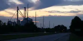 Montmorenci's grain elevators silhouetted at dusk | |
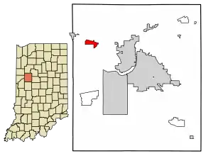 Location of Montmorenci in Tippecanoe County, Indiana. | |
| Coordinates: 40°28′27″N 087°01′46″W / 40.47417°N 87.02944°W | |
| Country | United States |
| State | Indiana |
| County | Tippecanoe |
| Township | Shelby |
| Area | |
| • Total | 1.59 sq mi (4.13 km2) |
| • Land | 1.59 sq mi (4.12 km2) |
| • Water | 0.00 sq mi (0.01 km2) |
| Elevation | 699 ft (213 m) |
| Population (2020) | |
| • Total | 173 |
| • Density | 108.74/sq mi (41.99/km2) |
| Time zone | UTC-5 (Eastern (EST)) |
| • Summer (DST) | UTC-4 (EDT) |
| ZIP code | 47906[3] |
| Area code | 765 |
| GNIS feature ID | 439370, 2583460 |
Montmorenci is an unincorporated census-designated place in Shelby Township, Tippecanoe County, Indiana.[4] Older maps sometimes spell the name Montmorency or Montmorencie.
It is part of the Lafayette, Indiana Metropolitan Statistical Area.
History
An old variant name of the community was called Bringham's Grove.[5]
A post office was established under the name Bringham's Grove in 1846, and was renamed to Montmorenci in 1853. It is currently not in operation.[6]
Geography
Montmorenci is located at 40°28'28" North, 87°01'46" West (40.474444, -87.029444) in Shelby Township, at the intersection of U.S. Routes 52 and 231. It has an elevation of 699 feet.
Demographics
| Census | Pop. | Note | %± |
|---|---|---|---|
| 2020 | 173 | — | |
| U.S. Decennial Census[7] | |||
Education
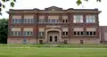 The old Montmorenci School building.
A brick school was built in 1913 at a cost of $40,000.[8] By 1923, this school housed classes from grades 1 to 12, and all other schools in the immediate district closed. Montmorenci School met a similar fate in 1966, closing as part of a consolidation that moved the upper grades into the new Benton Central Jr./Sr. High School.
Even though Montmorenci is in Tippecanoe County, all public education is provided by the Benton Community School Corporation from neighboring Benton County. Students attend Otterbein Elementary in grades K-6, then move on to Benton Central Jr./Sr. High School in grades 7-12.
References
- ↑ "2020 U.S. Gazetteer Files". United States Census Bureau. Retrieved March 16, 2022.
- ↑ "US Board on Geographic Names". United States Geological Survey. October 25, 2007. Retrieved January 31, 2008.
- ↑ "USPS.com® - ZIP Code Lookup". usps.com.
- ↑ "Montmorenci, Indiana". Geographic Names Information System. United States Geological Survey, United States Department of the Interior. Retrieved October 17, 2009.
- ↑ "USGS detail on Montmorenci - Variant Citation". Retrieved July 25, 2016.
- ↑ "Tippecanoe County". Jim Forte Postal History. Retrieved July 25, 2016.
- ↑ "Census of Population and Housing". Census.gov. Retrieved June 4, 2016.
- ↑ https://sites.rootsweb.com/~intcags/Schools/Shelby%20township%20_early_schools%20of%20TC.html
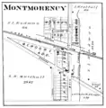 Montmorenci in 1878.
- The old Montmorenci School building.
 A home along Walnut Street.
Municipalities and communities of Tippecanoe County, Indiana, United States | ||
|---|---|---|
| Cities | Map of Indiana highlighting Tippecanoe County | |
| Towns | ||
| Townships | ||
| CDPs | ||
| Other communities | ||
| Ghost towns | ||
| Footnotes | ‡This populated place also has portions in an adjacent county or counties | |