Mont-Saint-Michel | |
|---|---|
 | |
| Motto: Vaillants comme nos pionniers (Valiant like our pioneers) | |
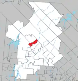 Location within Antoine-Labelle RCM | |
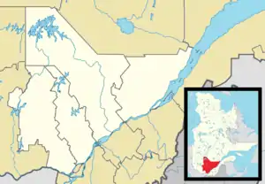 Mont-Saint-Michel Location in central Quebec | |
| Coordinates: 46°47′N 75°20′W / 46.783°N 75.333°W[1] | |
| Country | |
| Province | |
| Region | Laurentides |
| RCM | Antoine-Labelle |
| Constituted | September 11, 1928 |
| Government | |
| • Mayor | André-Marcel Evéquoz |
| • Federal riding | Laurentides—Labelle |
| • Prov. riding | Labelle |
| Area | |
| • Total | 145.14 km2 (56.04 sq mi) |
| • Land | 138.16 km2 (53.34 sq mi) |
| Population (2021)[3] | |
| • Total | 581 |
| • Density | 4.2/km2 (11/sq mi) |
| • Pop, 2016-2021 | |
| • Dwellings | 382 |
| Time zone | UTC−5 (EST) |
| • Summer (DST) | UTC−4 (EDT) |
| Postal code(s) | |
| Area code | 819 |
| Highways | |
| Website | www |
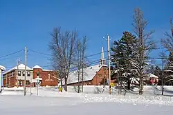
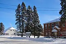
Mont-Saint-Michel is a municipality in the Laurentides region of Quebec, Canada, part of the Antoine-Labelle Regional County Municipality.
Geography
The main population centre of Mont-Saint-Michel is located 35 kilometres (22 mi) north of Mont-Laurier on the western banks of the Lièvre River. Its territory is characterized by a vast swamp and natural bog. Lake Gravel is one notable lake with vacation cottages surrounding it.[4]
History
The place was originally called Saint-Michel-des-Cèdres, but it was renamed to avoid confusion with the similarly named Saint-Michel-des-Saints. In 1912, its post office opened, and in 1915, a parish was set up as a mission under the name Saint-Michel-Archange.[1]
On September 11, 1928, the Municipality of Mont-Saint-Michel was created out of territory ceded from the United Township Municipality of Wurtele, Moreau et Gravel and Township of Décarie.[5]
Demographics
| 2021 | 2016 | |
|---|---|---|
| Population | 581 (+0.9% from 2016) | 576 (-9.0% from 2011) |
| Land area | 138.16 km2 (53.34 sq mi) | 139.02 km2 (53.68 sq mi) |
| Population density | 4.2/km2 (11/sq mi) | 4.1/km2 (11/sq mi) |
| Median age | 55.6 (M: 56.0, F: 55.2) | 53.4 (M: 54.8, F: 52.6) |
| Private dwellings | 382 (total) | 424 (total) |
| Median household income | $46,976 |
|
| ||||||||||||||||||||||||||||||||||||
| Source: Statistics Canada | |||||||||||||||||||||||||||||||||||||
Private dwellings occupied by usual residents (2021): 280 (total dwellings: 382)[3]
Mother tongue:
- English as first language: 1%
- French as first language: 98%
- English and French as first language: 0%
- Other as first language: 0%
Local government
List of former mayors:
- Roger Lapointe (...–2013)
- André-Marcel Évéquoz (2013–present)
See also
References
- 1 2 "Banque de noms de lieux du Québec: Reference number 42206". toponymie.gouv.qc.ca (in French). Commission de toponymie du Québec.
- 1 2 "Répertoire des municipalités: Geographic code 79110". www.mamh.gouv.qc.ca (in French). Ministère des Affaires municipales et de l'Habitation.
- 1 2 3 "Mont-Saint-Michel, Municipalité (MÉ) Census Profile, 2021 Census of Population". www12.statcan.gc.ca. Government of Canada - Statistics Canada. Retrieved 30 June 2022.
- ↑ "Histoire et patrimoine". www.montsaintmichel.ca (in French). Municipalité de Mont-Saint-Michel. Retrieved 30 June 2022.
- ↑ "Répertoire des entités géopolitiques: Mont-Saint-Michel (municipalité) 11.9.1928 - ..." www.mairesduquebec.com. Institut généalogique Drouin. Retrieved 30 June 2022.
- ↑ "2021 Community Profiles". 2021 Canadian Census. Statistics Canada. February 4, 2022. Retrieved 2022-06-30.
- ↑ "2016 Community Profiles". 2016 Canadian Census. Statistics Canada. August 12, 2021. Retrieved 2022-06-30.
- ↑ "2006 Community Profiles". 2006 Canadian Census. Statistics Canada. August 20, 2019.
- ↑ "2001 Community Profiles". 2001 Canadian Census. Statistics Canada. July 18, 2021.
External links
 Media related to Mont-Saint-Michel, Quebec at Wikimedia Commons
Adjacent Municipal Subdivisions | ||||||||||||||||
|---|---|---|---|---|---|---|---|---|---|---|---|---|---|---|---|---|
| ||||||||||||||||
| Cities/towns | |
|---|---|
| Municipalities | |
| Villages | |
| Unorganized territories | |
| |