Meybod County
Persian: شهرستان میبد | |
|---|---|
County | |
 A large dovecote in Meybod | |
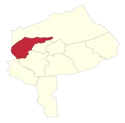 Location of Meybod County in Yazd province | |
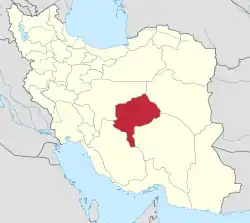 Location of Yazd province in Iran | |
| Coordinates: 31°57′N 53°43′E / 31.950°N 53.717°E[1] | |
| Country | |
| Province | Yazd |
| Capital | Meybod |
| Districts | Central, Bafruiyeh, Nadushan |
| Population (2016)[2] | |
| • Total | 99,727 |
| Time zone | UTC+3:30 (IRST) |
| Meybod County can be found at GEOnet Names Server, at this link, by opening the Advanced Search box, entering "9207380" in the "Unique Feature Id" form, and clicking on "Search Database". | |
Meybod County (Persian: شهرستان میبد) is in Yazd province, Iran. Its capital is the city of Meybod.
At the 2006 National Census, the county's population was 70,728 in 19,076 households.[3] The following census in 2011 counted 82,840 people in 23,300 households.[4]
At the 2016 census, the county's population was 99,727 in 29,684 households,[2] by which time Nadushan Rural District and the city of Nadushan had been separated from Khezrabad District of Ashkezar County in the establishment of Nadushan District.[5] At the same time, Bafruiyeh Rural District and the city of Bafruiyeh had been separated from the Central District in the establishment of Bafruiyeh District.[5]
Administrative divisions
The population history and structural changes of Meybod County's administrative divisions over three consecutive censuses are shown in the following table. The latest census shows three districts, five rural districts, and three cities.[2]
| Administrative Divisions | 2006[3] | 2011[4] | 2016[2] |
|---|---|---|---|
| Central District | 70,728 | 82,840 | 85,771 |
| Bafruiyeh RD | 8,399 | 3,866 | |
| Shohada RD | 4,034 | 5,581 | 5,059 |
| Bafruiyeh (city) | 6,486 | ||
| Meybod (city) | 58,295 | 66,907 | 80,712 |
| Bafruiyeh District | 10,837 | ||
| Bafruiyeh RD | 3,197 | ||
| Dareyn RD | 701 | ||
| Bafruiyeh (city) | 6,939 | ||
| Nadushan District1 | 3,119 | ||
| Nadushan RD | 216 | ||
| Sadrabad RD | 552 | ||
| Nadushan (city) | 2,351 | ||
| Total | 70,728 | 82,840 | 99,727 |
| RD: Rural District 1Transferred from Ashkezar County[5] | |||
References
- ↑ OpenStreetMap contributors (6 April 2023). "Meybod County" (Map). OpenStreetMap. Retrieved 6 April 2023.
- 1 2 3 4 "Census of the Islamic Republic of Iran, 1395 (2016)". AMAR (in Persian). The Statistical Center of Iran. p. 21. Archived from the original (Excel) on 18 November 2020. Retrieved 19 December 2022.
- 1 2 "Census of the Islamic Republic of Iran, 1385 (2006)". AMAR (in Persian). The Statistical Center of Iran. p. 21. Archived from the original (Excel) on 20 September 2011. Retrieved 25 September 2022.
- 1 2 "Census of the Islamic Republic of Iran, 1390 (2011)" (Excel). Iran Data Portal (in Persian). The Statistical Center of Iran. p. 21. Retrieved 19 December 2022.
- 1 2 3 "Four new cities were added to the map of country divisions". Mehr News (in Persian). Ministry of Interior. 13 January 2013. Archived from the original on 7 November 2023. Retrieved 7 November 2023.
Yazd Province, Iran | |||||||||||||||||||||
|---|---|---|---|---|---|---|---|---|---|---|---|---|---|---|---|---|---|---|---|---|---|
| Capital |  | ||||||||||||||||||||
| Counties and cities |
| ||||||||||||||||||||
| Landmarks |
| ||||||||||||||||||||
| populated places | |||||||||||||||||||||
| Capital | |||||||||||
|---|---|---|---|---|---|---|---|---|---|---|---|
| Districts |
| ||||||||||