Manjeshwaram Taluk | |
|---|---|
Taluk | |
 Manjeshwaram Taluk in Kasaragod dist | |
| Coordinates: 12°40′59″N 74°54′00″E / 12.683°N 74.9°E | |
| Country | |
| State | Kerala |
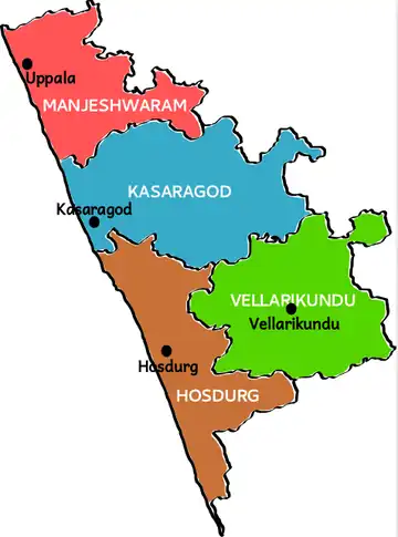
| District | Kasaragod |
| Headquarters | Uppala |
| Area | |
| • Total | 381.54 km2 (147.31 sq mi) |
| Population | |
| • Total | 268,642 |
| • Density | 700/km2 (1,800/sq mi) |
| Languages | |
| • Official | Malayalam, English[1] |
| • Spoken | Malayalam,Kannada,Tulu |
| Time zone | UTC+5:30 (IST) |
Manjeshwaram taluk is the northern most taluk of Kerala which borders Karnataka state. It is located in Kasaragod district, Kerala which was carved out from Kasaragod taluk on 2013.[2][3]
Constituent villages
Manjeshwaram taluk has 48 revenue villages.
- Manjeshwaram Panchayat: Kunjathur, Hosabettu, Udyavar(Manjeshwaram CT), Hosangadi, Badaje
- Meenja Panchayat: Meenja, Kadambar, Koliyoor, Kaliyoor, Talakala, Kuloor, Majibail, Moodambail
- Vorkady Panchayat: Vorkady, Pavoor, Kodalamogaru, Pathur
- Paivalike Panchayat: Paivalike, Chippar, Bayar, Kayyar, Kudalmarkala
- Enmakaje Panchayat: Enmakaje, Sheni, Padre, Kattukukke
- Puthige Panchayat: Edanad, Badoor, Kannur, Puthige, Angadimogaru, Mugu
- Kumbla Panchayat: Kumbla, Ichilampady, Mogral, Bombrana, Arikady, Kidoor, Ujarulvar,
- Mangalpady Panchayat: Uppala, Mannamkuzhi, Ichilangod, Mangalpady, Pathwadi, Bekoor, Heroor, Shiriya and Kubanoor[4]
See also
References
- ↑ "The Kerala Official Language (Legislation) Act, 1969" (PDF).
- ↑ "12 new taluks to be formed in Kerala". The Hindu. 21 March 2013. Archived from the original on 15 November 2017.
- ↑ "Kasargod to get 2 more taluks".
- ↑ "Villages in Manjeshwaram Taluk". Government of Kerala.
| Major Cities | |
|---|---|
| Taluks | |
This article is issued from Wikipedia. The text is licensed under Creative Commons - Attribution - Sharealike. Additional terms may apply for the media files.