Magherascouse
| |
|---|---|
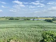 Magherascouse Lough 2023 | |
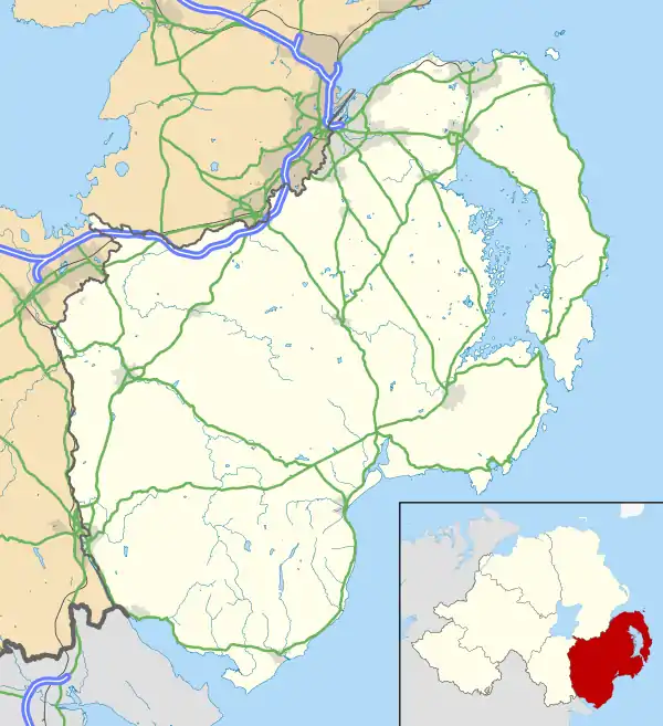 Magherascouse Location within County Down | |
| Area | 2.01 sq mi (5.2 km2) |
| Population | 329 (2021 Census) |
| • Density | 164/sq mi (63/km2) |
| Irish grid reference | J 44676 64696 |
| • Belfast | 9 mi (14.5 km) |
| District | |
| County | |
| Country | Northern Ireland |
| Sovereign state | United Kingdom |
| Post town | NEWTOWNARDS |
| Postcode district | BT23 |
| Dialling code | 028 |
| Police | Northern Ireland |
| Fire | Northern Ireland |
| Ambulance | Northern Ireland |
| UK Parliament | |
| NI Assembly | |
Magherascouse (MAGH-era-SCOUSE, from Irish: Machaire Scamha, meaning "Plain of the bare patch of rocks"[1]) is a rural townland near Ballygowan in County Down,[2] Northern Ireland. It has an area of 1286.45 acres (5.206 km2).[3][4][5][6] It is situated in the civil parish of Comber,[7][8][9] the Poor Law Union of Newtownards and the historic barony of Castlereagh Lower,[10] located 2 miles south of Comber.[11] It lies within the Electoral Division of Ballygowan[12] which is part of the Ards and North Down Borough Council.[13][14][15]
History
Before the early 17th century Plantation of Ulster, when many Lowland Scots moved across the Irish Sea to settle in Northern Ireland on lands granted by King James I to James Hamilton and Hugh Montgomery, the area of Magherascouse was sparsely inhabited by Irish Gaels. The townland was within the territory of Clannaboy inhabited by the tribe of Henry Caoch O'Niell the Blind, a member of the Clannaboy O'Niell family who was blinded in 1426 by the sons of Brian Ballagh O'Neill, his brother.[16][17][18] In the Irish Rebellion of 1798 a man of the name, Nevin Kerns from Magherascouse participated in the Battle of Saintfield.[19]
In 1837 farms were from 10 to 30 acres, the land quality was described as middling and rent was 21- 32 shillings an acre.[20] On 10th September 1858 the B&CDR opened a railway line from Comber to Ballynahinch and it passed through Magherascouse, a nearby station being Ballygowan.[21] Lord Dufferin sold the townland of Magherascouse to Robert G. Dunville in 1877, it was valued at £1,341 in 1881 and Mr Dunville still owned it in 1889.[22][23] From the mid-19th century through the early 20th century the population of Magherascouse declined considerably as many people emigrated to North America or found work in Comber, Saintfield and particularly in Belfast. The railway line which passed through Magherascouse was closed by the Ulster Transport Authority on 15th January 1950.[24]
Demography
The population of Magherascouse declined a considerable amount in the first half of the 20th century as people moved away and found jobs in nearby towns and cities like; Comber, Saintfield and particularly Belfast.
1659 Census
In 1659 the population of Magherascouse was 29.[25]
- 48.3%(14) were English or Scotts
- 51.7%(15) were Irish
1837
In 1837 the population of Magherascouse was 732.[26]
- 48.6%(356) Male
- 51.4%(376) Female
1841 Census
In 1841 the population of Magherascouse was 756 from 119 households(excluding 4 uninhabited houses).[27][28][29][23]
- 49.3%(373) Male
- 50.7%(383) Female
1851 Census
In 1851 the population of Magherascouse was 635 from 107 households(excluding 1 uninhabited house).[30][29][23]
- 34.7%(238) Male
- 50.7%(348) Female
1861 Census
In 1861 the population of Magherascouse was 636 from 117 households(excluding 2 uninhabited houses).[29][31][29][23]
- 44.7%(284) Male
- 55.3%(352) Female
1871 Census
In 1871 the population of Magherascouse was 527 from 98 households(excluding 4 uninhabited houses).[29][23]
- 49.3%(260) Male
- 50.7%(287) Female
1881 Census
In 1881 the population of Magherascouse was 483 from 94 households(excluding 3 uninhabited houses).[23]
- 47.4%(229) Male
- 52.6%(264) Female
1891 Census
In 1881 the population of Magherascouse was 410 from 84 households(excluding 17 uninhabited houses).[32]
- 45.4%(186) Male
- 54.6%(224) Female
1901 Census
On Census Day (Sunday 31 March 1901) the population of Magherascouse was 431 from 81 households(excluding 8 uninhabited houses).[33]
- 49.7%(214) Male
- 50.3%(217) Female
- 8.6%(37) reported Catholic
- 88.9%(383) were Protestant
- 7%(30) reported as attending the Church of Ireland or the Irish Church
- 81.9%(353) reported Presbyterian
- 2.6%(11) reported as other
1911 Census
On Census Day (1 May 1911) the population of Magherascouse was 353 from 67 households.[34][35]
- 48.4%(171) Male
- 51.6%(182) Female
- 15%(53) reported Catholic
- 84.1%(297) were Protestant
- 6.5%(23) reported as attending the Church of Ireland or the Irish Church
- 77.6%(274) reported Presbyterian
- 0.8%(3) reported as other
1926 Census
On Census Day (Midnight of 18–19 April 1926) the population of Magherascouse was 342 from 72 households(excluding 3 uninhabited houses).[36]
- 51.8%(177) Male
- 48.2%(165) Female
1937 Census
On Census Day (Midnight of 28 February-1 March 1937)[37] the population of Magherascouse was 302 from 78 households.[38]
1951 Census
On Census Day (Midnight of 8–9 April 1951) the population of Magherascouse was 310 from 78 households(excluding 5 uninhabited houses).[39]
- 50.6%(157) Male
- 49.4%(153) Female
Education

Magherascouse has had three schools in its history, two of these schools were around during the early 19th century. After the Stanley letter, which led to the nationalisation of schools in Northern ireland, one of the schools became known as the Magherascouse School, this school was built in 1820 by Lord Dufferin for the benefit of his tenantry and existed at least to 1963. This school was typically a Presbyterian school, it had a new school building built around the late 19th century to early 20th century which was funded by Lord Dufferin, John Craigan was appointed Head Master in 1885 and was Principal there until at least 1918, after John Craigan the new Headmistress was Miss Mercer who retired when she turned 60, after Miss Mercer the Headmistress then became Miss Corrigan (later Mrs Jack), Miss Corrigan became burdened with leukemia and had to leave the school, a woman of the name Gladys McBride happened to be vice principal nearby in Ballykeigle Primary School and so she became the last Headmistress of Magherascouse National School before it was closed and put up for sale.[40][41]
The other primary school was St. Mary's School, Burns's Cross, and was built in 1919 by Fr. Shields for the Catholic population in the area and to replace a school in Carrickmannon known as 'The Mill'. St. Mary's cost the Church £45 at the time to construct and was built almost entirely by a local man named James Mitchell who used voluntary labour to reduce the cost of construction, half an acre of land was donated by the Truman family who owned a farm there at the time. It was built out of locally quarried blue stone from Ballygowan. In the 1920s to the 1940s the Headmistress was Mrs McGaughey.[42]
The third school building is the oldest of the three, it was described in 1898 as a 'hedge school' which existed long before the Magherascouse School. The school was decommissioned shortly after the Stanley Letter where it then was temporarily rented to a man named John Lyons as a private dwelling by Daniel McMorran, after this the building was finally demolished into a heap of rubble in the corner of a field possibly due to the building starting to collapse.
All three schools are now defunct, Magherascouse school now being a private dwelling and St. Mary's School is now rented as offices to the NHS and the third school was demolished.[43][44][45]
See also
References
- ↑ "Place Names NI Magherascouse". www.placenamesni.org. Retrieved 10 November 2023.
- ↑ "Nisra 1926 Census Magherascouse County Down" (PDF).
- ↑ "Category:Magherascouse, County Down - Wikimedia Commons". commons.wikimedia.org. Retrieved 21 October 2023.
- ↑ "Townlands.ie land area Magherascouse". www.townlands.ie. Retrieved 22 October 2023.
- ↑ "Nisra 1926 Census Magherascouse Land Area" (PDF).
- ↑ "Magherascouse Land Area and Map".
- ↑ "Comber townlands". freepages.rootsweb.com. Retrieved 21 October 2023.
- ↑ "Griffith's Evaluation Magherascouse".
- ↑ "1659 Census of Ireland" (PDF).
- ↑ Down, ITS New Media Ltd-Newry, Co. "Magherascouse, Comber Parish, County Down, Northern Ireland". www.emeraldancestors.com. Retrieved 21 October 2023.
{{cite web}}: CS1 maint: multiple names: authors list (link) - ↑ "Placenames.ni Magherascouse".
- ↑ "Nisra 1926 Census Magherascouse Electoral Division" (PDF).
- ↑ "Townlands.ie Ballygowan Electoral division". www.townlands.ie. Retrieved 22 October 2023.
- ↑ "Magherascouse Townland Logain.ie". 10 November 2023.
- ↑ "IreAtlas Townland Search Form Magherascouse". thecore.com. 10 November 2023.
- ↑ Belfast Natural History and Philosophical Society (1821- ) (1960). Proceedings and Reports of the Belfast Natural History and Philosophical Society for the Session. The Society.
{{cite book}}: CS1 maint: numeric names: authors list (link) - ↑ James O'Laverty (1880). An historical account of the diocese of Down and Connor, ancient and modern. J. Duffy.
- ↑ "Library Ireland, Brian Ballagh O'Niell". 21 November 2023.
- ↑ Brian S. Turner; Kenneth Dawson; Myrtle Hill (1998). 1798 Rebellion in County Down. Retrieved 30 November 2023.
- ↑ "Ros Davies, Place Names of Co. Down; M..." 30 November 2023.
- ↑ "Dundonald Rail, BCDR History". 30 November 2023.
- ↑ "Google Books, Quarterly Irish Land Reports". 19 November 2023.
- 1 2 3 4 5 6 "1881 Census of Ireland, County Down". 29 November 2023.
- ↑ "Dundonald Rail, BCDR History". 30 November 2023.
- ↑ "1659 Census of Ireland" (PDF).
- ↑ "RosDavies History Magherascouse School".
- ↑ "Google Books, Reports from the Commissioners". 19 November 2023.
- ↑ "Google Books, Reports from the Commisioners". 19 November 2023.
- 1 2 3 4 5 "1871 Census of Ireland Volume III" (PDF). 29 November 2023.
- ↑ "Google Books, Reports from the Commisioners". 19 November 2023.
- ↑ "Census of Ireland, Magherascouse". Retrieved 6 December 2023.
- ↑ "1891 Census of Ireland, County Down". Retrieved 5 December 2023.
- ↑ "1901 Census national archives".
- ↑ "1911 Census national archives".
- ↑ "NISRA 1926 & 1911 Census Population Magherascouse" (PDF).
- ↑ "NISRA 1926 Census Population Magherascouse" (PDF).
- ↑ "NISRA Census Day 1937" (PDF).
- ↑ "NISRA 1951 & 1937 Census Population Magherascouse" (PDF).
- ↑ "NISRA 1951 Census Population Magherascouse" (PDF).
- ↑ "Library Ireland".
- ↑ "Ros Davies Genealogy Surnames".
- ↑ "Lennon Wylie Ballygowan". 16 November 2023.
- ↑ "PRONI Historical Maps viewer". 14 November 2023.
- ↑ "RosDavies History Magherascouse School".
- ↑ "Griffith's Valuation Ireland".