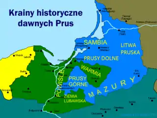
Map of historical regions of Prussia.
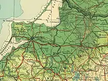
1920 map of the Lower Prussia.
Lower Prussia[lower-alpha 1] is a historical region in the eastern Prussia. On the north it borders the norther Sambia Peninsula via the Pregolya river, on the east, the Łyna river, forming boundary with Lithuania Minor. On the south it borders Warmia, and Masuria. In modern times, it is divided between Kaliningrad Oblast, Russia, and Warmian-Masurian Voivodeship, Poland.[1][2][3]
Citations
Notes
References
This article is issued from Wikipedia. The text is licensed under Creative Commons - Attribution - Sharealike. Additional terms may apply for the media files.