 | |
 Lime Cay  Lime Cay | |
| Geography | |
|---|---|
| Location | Caribbean |
| Coordinates | 17°55′06.36″N 76°49′11.96″W / 17.9184333°N 76.8199889°W |
| Archipelago | Port Royal Cays |
| Total islands | 8 |
| Major islands | Lime Cay |
| Area | 0.03 km2 (0.012 sq mi) |
| Administration | |
| Parish | Kingston |
| Neighborhood | Port Royal |
| Demographics | |
| Population | 0 |
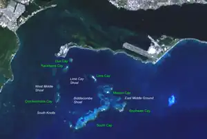
Lime Cay is the main islet off the shore of Port Royal Cays, Jamaica. It located in the northeast region of the reef.
Geography
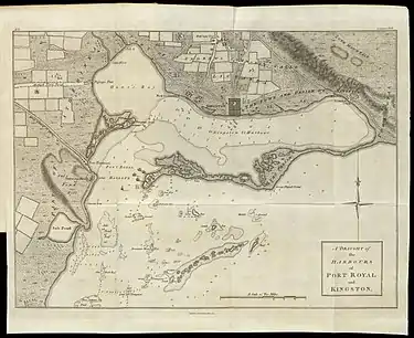
Lime Key on map of 1774
Located 15 - 30 minutes by boat from Port Royal. It has a small beach which makes it a popular location for recreation and sunbathing. It is a regular hotspot for post-party-goers, and during holiday season (Summer and Christmas) weekends the island is often swarmed with boats, music and socialites. Lime Cay measures 380 meters northwest-southeast, and is up to 80 meters wide, measuring 2 ha in area.[1] About half of the area is wooded, the rest is sand and coral. It has no infrastructure except for a small open building used as a Gazzebo. The building is located at 17°55′06.36″N 76°49′11.96″W / 17.9184333°N 76.8199889°W.
References
This article is issued from Wikipedia. The text is licensed under Creative Commons - Attribution - Sharealike. Additional terms may apply for the media files.