Les Bondons | |
|---|---|
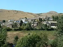 A general view of Les Bondons | |
Location of Les Bondons | |
 Les Bondons  Les Bondons | |
| Coordinates: 44°23′14″N 3°37′12″E / 44.3872°N 3.62000°E | |
| Country | France |
| Region | Occitania |
| Department | Lozère |
| Arrondissement | Florac |
| Canton | Saint-Étienne-du-Valdonnez |
| Intercommunality | CC Gorges Causses Cévennes |
| Government | |
| • Mayor (2020–2026) | Francis Durand[1] |
| Area 1 | 45.54 km2 (17.58 sq mi) |
| Population | 145 |
| • Density | 3.2/km2 (8.2/sq mi) |
| Time zone | UTC+01:00 (CET) |
| • Summer (DST) | UTC+02:00 (CEST) |
| INSEE/Postal code | 48028 /48400 |
| Elevation | 600–1,569 m (1,969–5,148 ft) (avg. 863 m or 2,831 ft) |
| 1 French Land Register data, which excludes lakes, ponds, glaciers > 1 km2 (0.386 sq mi or 247 acres) and river estuaries. | |
Les Bondons (French pronunciation: [le bɔ̃dɔ̃]; Occitan: Los Bondons) is a commune in the Lozère department in southern France.
Population
| Year | Pop. | ±% p.a. |
|---|---|---|
| 1968 | 230 | — |
| 1975 | 234 | +0.25% |
| 1982 | 194 | −2.64% |
| 1990 | 159 | −2.46% |
| 1999 | 150 | −0.65% |
| 2009 | 141 | −0.62% |
| 2014 | 143 | +0.28% |
| 2020 | 145 | +0.23% |
| Source: INSEE[3] | ||
See also
References
- ↑ "Répertoire national des élus: les maires" (in French). data.gouv.fr, Plateforme ouverte des données publiques françaises. 13 September 2022.
- ↑ "Populations légales 2020". The National Institute of Statistics and Economic Studies. 29 December 2022.
- ↑ Population en historique depuis 1968, INSEE
Wikimedia Commons has media related to Les Bondons.
This article is issued from Wikipedia. The text is licensed under Creative Commons - Attribution - Sharealike. Additional terms may apply for the media files.