Latgale Region | |
|---|---|
 Coat of arms | |
 | |
| Country | Latvia |
| Largest city | Daugavpils |
| Area | |
| • Total | 14,549 km2 (5,617 sq mi) |
| Population (2022)[1] | |
| • Total | 247,220 |
| • Density | 17/km2 (44/sq mi) |
| Gross Regional Product | |
| • Total | €2.068 billion |
| • Per capita | €8,111 |
| Website | https://lpr.gov.lv/en |
Latgale Region (Latvian: Latgales reģions), officially Latgale Planning Region (Latvian: Latgales plānošanas reģions), is one of the five planning regions of Latvia, it is situated in the eastern part of Latvia. The state institution was founded on 2 October 2006, based on the creation of the region territory as prescribed by Regulations No. 133 of the Cabinet of Ministers as of 25 March 2003, the "Regulations on Territories of Planning Regions". As of 2020, the region's population was 281,116.[1]
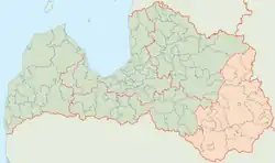
Geography
The territory of the Latgale Region was created in 2006.
Economy
The gross regional product (GRP) of the region was €2.1 billion in 2020.[3]
Demography
Latgale Region had a population of 247,220 inhabitants in 2022.[4]
See also
References
- 1 2 "ISG020. Population number and its change by statistical region, city, town, 21 development centres and county". Central Statistical Bureau of Latvia. 2020-01-01. Retrieved 2021-02-12.
- ↑ "Gross domestic product in regions". www.stat.gov.lv.
- ↑ "Gross domestic product by region and city (at current prices) – Territorial unit, Indicator and Time period".
- ↑ "ISG020. Iedzīvotāju skaits un tā izmaiņas statistiskajos reģionos, republikas pilsētās, novadu pilsētās un novados". csb.gov.lv (in Latvian). Retrieved 2019-08-25.
External links
This article is issued from Wikipedia. The text is licensed under Creative Commons - Attribution - Sharealike. Additional terms may apply for the media files.