Klánovice
Klánovice | |
|---|---|
Municipal District of Prague Cadastral Area of Prague | |
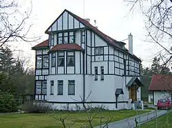 historical house in Klánovice | |
 Flag  Coat of arms | |
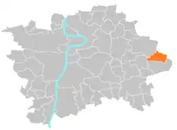 Location of Klánovice in Prague | |
| Coordinates: 50°5′39″N 14°40′10″E / 50.09417°N 14.66944°E | |
| Country | Czech Republic |
| Region | Prague |
| District | Prague 21 |
| Government | |
| • Mayor | Alena Kolovrátková |
| Area | |
| • Total | 5.90 km2 (2.28 sq mi) |
| Population (2008) | |
| • Total | 2,939 |
| • Density | 500/km2 (1,300/sq mi) |
| Time zone | UTC+1 (CET) |
| • Summer (DST) | UTC+2 (CEST) |
| Postal code | 190 14 |
| Website | http://www.praha-klanovice.cz |
Klánovice (German: Klanowitz) is a municipal district (městská část) and cadastral area (katastrální území) in Prague, Czech Republic. Originally a village (since 1878), later municipality (since 1920), it became district of Prague in 1974.[1]
It is located at the eastern limit of the city. It borders Prague 20 (Horní Počernice) in the northwest, Běchovice in the west, Újezd nad Lesy in the southwest and south and Prague-East District (municipality of Šestajovice) in the northeast.
References
Wikimedia Commons has media related to Klánovice.
External links
This article is issued from Wikipedia. The text is licensed under Creative Commons - Attribution - Sharealike. Additional terms may apply for the media files.