Kirk, West Virginia | |
|---|---|
 Kirk, West Virginia  Kirk, West Virginia | |
| Coordinates: 37°53′39″N 82°14′36″W / 37.89417°N 82.24333°W | |
| Country | United States |
| State | West Virginia |
| County | Mingo |
| Elevation | 873 ft (266 m) |
| Time zone | UTC-5 (Eastern (EST)) |
| • Summer (DST) | UTC-4 (EDT) |
| Area code(s) | 304 & 681 |
| GNIS feature ID | 1554888[1] |
Kirk is an unincorporated community in Mingo County, West Virginia, United States. Kirk is 10 miles (16 km) northeast of Kermit.
An early variant name was Buttercup.[2]
References
- ↑ "US Board on Geographic Names". United States Geological Survey. October 25, 2007. Retrieved January 31, 2008.
- ↑ Kenny, Hamill (1945). West Virginia Place Names: Their Origin and Meaning, Including the Nomenclature of the Streams and Mountains. Piedmont, WV: The Place Name Press. p. 353.
Municipalities and communities of Mingo County, West Virginia, United States | ||
|---|---|---|
| City | 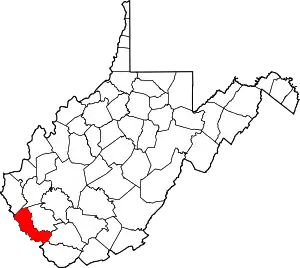 Mingo County map | |
| Towns | ||
| CDPs | ||
| Other communities |
| |
| Footnotes | ‡This populated place also has portions in an adjacent county or counties | |
This article is issued from Wikipedia. The text is licensed under Creative Commons - Attribution - Sharealike. Additional terms may apply for the media files.