Kazipur
কাজীপুর | |
|---|---|
 | |
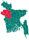
 Kazipur Location in Bangladesh | |
| Coordinates: 24°38.5′N 89°39′E / 24.6417°N 89.650°E | |
| Country | |
| Division | Rajshahi Division |
| District | Sirajganj District |
| Government | |
| Area | |
| • Total | 368.63 km2 (142.33 sq mi) |
| Population (2011) | |
| • Total | 285,309 |
| • Density | 770/km2 (2,000/sq mi) |
| Time zone | UTC+6 (BST) |
| Postal code | 6710 |
| Website | kazipur |
Kazipur (Bengali: কাজীপুর) is an upazila, or sub-district of Sirajganj District, located in Rajshahi Division, Bangladesh.
Geography
Kazipur is located at 24°38′30″N 89°39′00″E / 24.6417°N 89.6500°E. The total area of the upazila is 368.63 km2 (142 sq mi).[1] The main river is the Jamuna, which branches and rejoins several times. The Ichamati crosses the western edge of the upazila. It is bounded by Dhunat, Sariakandi and Sarishabari upazilas on the north, Sirajganj sadar upazila on the south, Sarishabari upazila and the Jamuna river on the east, Dhunat upazila on the west.[1]
Demographics
Par the 2001 Bangladesh census, Kazipur has a population of 2,66,950; male constituted 136056 of the population, female 130894.[1] As of the 1991 Bangladesh census, Kazipur had a population of 244,804. 50.39% male and 49.61% female. The adult population is 120,257. Kazipur had an average literacy rate of 30.5% (7+ years), against the national average of 42.4% literate.[2]
Religion
Administration
Kazipur Thana, now an upazila, was formed in 1920.[1]
Kazipur Upazila is divided into Kazipur Municipality and 12 union parishads: Chargirish, Chalitadanga, Gandail, Kazipur, Khasrajbari, Maijbari, Mansur Nagar, Natuarpara, Nishchintapur, Sonamukhi, Subhagacha, and Tekani. The union parishads are subdivided into 108 mauzas and 172 villages.[4][5]
Kazipur Municipality is subdivided into 9 wards and 11 mahallas.[4]
Education
Educational institutions: College: 1. Govt. Bangabandhu Degree College (1998), 2.Kazipur Government Mansur Ali College,R.I.M Degree College-Tenglahata(1969), Meghai UUI Multilateral High School (1919), Subgacha Tenglahata Rafatullah Multilateral High School (1944) Gandhail High School (1946), Rani Dinamoni High School (1957), Kazipur A.M.u Government Girls' High School, Tarakandi High School (1937). Shaheed M Monsur Ali Institute Of Health Technology-IHT, Kazipur, Sirajganj was founded in 2015. Begum Amina Mansur Textile Engineering Institute, Kazipur, Sirajganj project is ongoing and is expected to start enrolment anytime soon.
Notable People
- Captain Muhammad Mansur Ali was the national leader of Bangladesh.
- Mohammed Nasim MP (former Home Minister and Health Minister)
References
- 1 2 3 4 Rafiqul Islam (2012). "Kazipur Upazila". In Sirajul Islam and Ahmed A. Jamal (ed.). Banglapedia: National Encyclopedia of Bangladesh (Second ed.). Asiatic Society of Bangladesh.
- ↑ "Population Census Wing, BBS". Archived from the original on 2005-03-27. Retrieved November 10, 2006.
- ↑ Bangladesh Bureau of Statistics (2011). "Population & Housing Census" (PDF). Bangladesh Government. Archived from the original (PDF) on 3 September 2017. Retrieved 17 April 2015. p. xxiii:
Population By Religion (%) Muslim 90.39 Hindu 8.54 Buddhist 0.60 Christian 0.37 Others 0.14
- 1 2 "District Statistics 2011: Sirajganj" (PDF). Bangladesh Bureau of Statistics. Archived from the original (PDF) on 13 November 2014. Retrieved 14 July 2014.
- ↑ কাজীপুর উপজেলা [Unions]. Kazipur Upazila (in Bengali). Bangladesh National Portal.
| Upazila/Thana: | ||
|---|---|---|