Karlstein an der Thaya | |
|---|---|
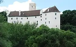 Karlstein Castle | |
 Coat of arms | |
 Karlstein an der Thaya Location within Austria | |
| Coordinates: 48°53′00″N 15°24′00″E / 48.88333°N 15.40000°E | |
| Country | Austria |
| State | Lower Austria |
| District | Waidhofen an der Thaya |
| Government | |
| • Mayor | Siegfried Walch (ÖVP) |
| Area | |
| • Total | 48.87 km2 (18.87 sq mi) |
| Elevation | 442 m (1,450 ft) |
| Population (2018-01-01)[2] | |
| • Total | 1,468 |
| • Density | 30/km2 (78/sq mi) |
| Time zone | UTC+1 (CET) |
| • Summer (DST) | UTC+2 (CEST) |
| Postal code | 3822 |
| Area code | 02844 |
| Vehicle registration | WT |
| Website | www.karlstein-thaya.gv.at |
Karlstein an der Thaya is a municipality and market town in the district of Waidhofen an der Thaya in the Austrian state of Lower Austria.
Population
| Year | Pop. | ±% |
|---|---|---|
| 1971 | 1,948 | — |
| 1981 | 1,723 | −11.6% |
| 1991 | 1,596 | −7.4% |
| 2001 | 1,586 | −0.6% |
Local council
Elections were held in 2015 with the following results:
- ÖVP 13 seats
- SPÖ 4 seats
- FPÖ 2 seats
References
- ↑ "Dauersiedlungsraum der Gemeinden Politischen Bezirke und Bundesländer - Gebietsstand 1.1.2018". Statistics Austria. Retrieved 10 March 2019.
- ↑ "Einwohnerzahl 1.1.2018 nach Gemeinden mit Status, Gebietsstand 1.1.2018". Statistics Austria. Retrieved 9 March 2019.
External links
Wikimedia Commons has media related to Karlstein an der Thaya.
This article is issued from Wikipedia. The text is licensed under Creative Commons - Attribution - Sharealike. Additional terms may apply for the media files.