Kadma
Kadma II | |
|---|---|
Census Town | |
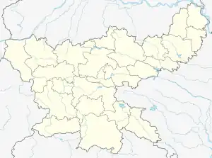 Kadma Location in Jharkhand, India  Kadma Kadma (India) | |
| Coordinates: 24°00′05″N 85°19′35″E / 24.001389°N 85.326358°E | |
| Country | |
| State | Jharkhand |
| District | Hazaribagh |
| Government | |
| • Type | Federal democracy |
| Area | |
| • Total | 2.34 km2 (0.90 sq mi) |
| Population (2011) | |
| • Total | 7,239 |
| • Density | 3,100/km2 (8,000/sq mi) |
| Languages (*For language details see Katkamdag (community development block)#Language and religion) | |
| • Official | Hindi, Urdu |
| Time zone | UTC+5:30 (IST) |
| PIN | 825302 |
| Telephone/ STD code | 06546 |
| Vehicle registration | JH 02 |
| Lok Sabha constituency | Hazaribagh |
| Vidhan Sabha constituency | Hazaribagh |
| Website | hazaribag |
Kadma (referred to in census records as Kadma II) is a census town in the Katkamdag CD block in the Hazaribagh Sadar subdivision of the Hazaribagh district in the Indian state of Jharkhand.
Geography
CT: census town, R: rural/ urban centre, T: tourist centre, C: educational centre, F: facility
Owing to space constraints in the small map, the actual locations in a larger map may vary slightly
Location
Kadma is located at 24°00′05″N 85°19′35″E / 24.001389°N 85.326358°E.
Demographics
According to the 2011 Census of India, Kadma (location code 368710) had a total population of 7,239, of which 3,778 (52%) were males and 3,461 (48%) were females. Population in the age range 0–6 years was 947. The total number of literate persons in Kadma was 5,449 (86.60% of the population over 6 years).[1]
Infrastructure
According to the District Census Handbook 2011, Hazaribagh, Kadma No. II covered an area of 2.34 km2. Among the civic amenities, it had 8 km roads with both open and covered drains, the protected water supply involved uncovered well, hand pump. It had 1,202 domestic electric connections. Among the educational facilities it had 4 primary schools, 3 middle schools, other educational facilities at Hazaribagh 5 km away.[2]
Transport
Hazaribagh Town railway station on the Koderma–Hazaribagh–Barkakana–Ranchi line is located nearby.[3]
References
- ↑ "District Census Handbook, Hazaribagh, Series 21, Part XII B" (PDF). Page 220: District Primary Census Abstract, 2011 census. Directorate of Census Operations Jharkhand. Retrieved 22 January 2021.
- ↑ "District Census Handbook Hazaribagh, Census of India 2011, Series 20, Part XII A" (PDF). Pages 651-662. Directorate of census Operations, Jharkhand. Retrieved 21 January 2021.
- ↑ "73371 => 53371 Koderma-Barkakhana Passenger". Time Table. Indiarailinfo. Retrieved 23 January 2021.
Cities, towns and locations in Hazaribagh district, North Chotanagpur division | ||
|---|---|---|
| Cities, municipal and census towns |  Divisions of Jharkhand | |
| Locations other than cities and towns | ||
| Related topics |
| |