Template:Attached KML/KA postcode area
KML is from Wikidata
Kilmarnock | |
|---|---|
 KA | |
| Coordinates: 55°33′50″N 4°36′14″W / 55.564°N 4.604°W | |
| Country | United Kingdom |
| Postcode area | KA |
| Postcode area name | Kilmarnock |
| Post towns | 23 |
| Postcode districts | 30 |
| Postcode sectors | 87 |
| Postcodes (live) | 11,605 |
| Postcodes (total) | 14,127 |
| Statistics as at May 2020[1] | |
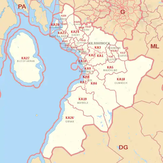
The KA postcode area, also known as the Kilmarnock postcode area,[2][3] is a group of 30 postcode districts in south-west Scotland, within 23 post towns. These cover East Ayrshire, North Ayrshire (including the Isle of Arran) and South Ayrshire.
Coverage
The approximate coverage of the postcode districts:
| Postcode district | Post town | Coverage | Local authority area(s) |
|---|---|---|---|
| KA1 | KILMARNOCK | Kilmarnock Centre, Bonnyton, Grange, Bellfield, Riccarton, Shortlees, Caprington, Hurlford | East Ayrshire |
| KA2 | KILMARNOCK | Knockentiber, Crosshouse, Dundonald | East Ayrshire, South Ayrshire |
| KA3 | KILMARNOCK | Longpark, Hillhead, Knockinlaw, Altonhill, Onthank, Beansburn, Southcraigs, New Farm Loch, Whinpark, Kilmaurs, Stewarton, Dunlop, Lugton, Fullwood, Kingsford, Fenwick, Crookedholm | East Ayrshire, North Ayrshire |
| KA4 | GALSTON | Galston, Moscow | East Ayrshire |
| KA5 | MAUCHLINE | Mauchline, Tarbolton, Catrine, Sorn | East Ayrshire |
| KA6 | AYR | Mossblown, Annbank, Coylton, Dalrymple, Hollybush, Drongan, Rankinston, Patna, Waterside, Dalmellington, Bellsbank | South Ayrshire, East Ayrshire |
| KA7 | AYR | Ayr Centre, Holmston, Forehill, Belmont, Castlehill, Kincaidson, Alloway, Doonfoot, Masonhill, Dunure | South Ayrshire |
| KA8 | AYR | Braehead, Newton on Ayr, Woodfield, Heathfield, Whitletts, Lochside, Dalmilling, Craigie, Wallacetown | South Ayrshire |
| KA9 | PRESTWICK | Prestwick, Monkton | South Ayrshire |
| KA10 | TROON | Troon, Barassie, Muirhead, Loans | South Ayrshire |
| KA11 | IRVINE | Perceton, Lawthorn, Girdle Toll, Stanecastle, Bourtreehill, Broomlands, Dreghorn, Springside | North Ayrshire |
| KA12 | IRVINE | Irvine Centre, Fullarton, Stanecastle | North Ayrshire |
| KA13 | KILWINNING | Kilwinning | North Ayrshire |
| KA14 | BEITH | Beith, Glengarnock, Longboat | North Ayrshire |
| KA15 | BEITH | Beith, Glengarnock, Longboat | North Ayrshire |
| KA16 | NEWMILNS | Newmilns, Greenholm | East Ayrshire |
| KA17 | DARVEL | Darvel | East Ayrshire |
| KA18 | CUMNOCK | Cumnock, Auchinleck, Ochiltree, New Cumnock, Muirkirk, Smallburn, Lugar, Logan | East Ayrshire |
| KA19 | MAYBOLE | Maybole, Crosshill, Straiton, Kirkoswald | South Ayrshire |
| KA20 | STEVENSTON | Stevenston | North Ayrshire |
| KA21 | SALTCOATS | Saltcoats | North Ayrshire |
| KA22 | ARDROSSAN | Ardrossan, Whitlees, Chapelhill | North Ayrshire |
| KA23 | WEST KILBRIDE | West Kilbride | North Ayrshire |
| KA24 | DALRY | Dalry, Drakemyre | North Ayrshire |
| KA25 | KILBIRNIE | Kilbirnie | North Ayrshire |
| KA26 | GIRVAN | Girvan, Turnberry, Dailly, Old Dailly, Ballantrae, Colmonell, Barrhill | South Ayrshire |
| KA27 | ISLE OF ARRAN | Brodick, Lochranza, Machrie, Kilmory, Kildonan, Holy Island | North Ayrshire |
| KA28 | ISLE OF CUMBRAE | Millport | North Ayrshire |
| KA29 | LARGS | Largs, Glenside, Fairlie, Kelburn | North Ayrshire |
| KA30 | LARGS | Largs | North Ayrshire |
Map
Template:Attached KML/KA postcode area
KML is from Wikidata
See also
References
- ↑ "ONS Postcode Directory Version Notes" (ZIP). National Statistics Postcode Products. Office for National Statistics. May 2020. Table 2. Retrieved 19 June 2020. Coordinates from mean of unit postcode points, "Code-Point Open". OS OpenData. Ordnance Survey. February 2012. Retrieved 21 April 2012.
- ↑ Address Management Guide (5th ed.). Royal Mail Group plc. March 2007. Retrieved 22 October 2012.
- ↑ Office for National Statistics (1999). The Official Yearbook of the United Kingdom (PDF) (2000 ed.). London: The Stationery Office. "UK Postal Areas", map opposite p. 5. ISBN 0-11-621098-2. Retrieved 22 October 2012.
External links
This article is issued from Wikipedia. The text is licensed under Creative Commons - Attribution - Sharealike. Additional terms may apply for the media files.