Jones Chapel, Alabama | |
|---|---|
 Jones Chapel, Alabama  Jones Chapel, Alabama | |
| Coordinates: 34°12′37″N 87°03′07″W / 34.21028°N 87.05194°W | |
| Country | United States |
| State | Alabama |
| County | Cullman |
| Elevation | 981 ft (299 m) |
| Time zone | UTC-6 (Central (CST)) |
| • Summer (DST) | UTC-5 (CDT) |
| Area code(s) | 256 & 938 |
| GNIS feature ID | 159870[1] |
Jones Chapel is an unincorporated community in Cullman County, Alabama, United States, located on Alabama State Route 74, 13.1 miles (21.1 km) west-northwest of Cullman.
History
Jones Chapel is named after a local church, which itself was named in honor of "Turkeytail" Jones, an early settler of the area.[2] Turkeytail Jones owned, and operated a trading post at the center of the community. He traded goods with the local Native American tribes for furs.
A post office operated under the name Jones Chapel from 1868 to 1907.[3]
References
- ↑ "Jones Chapel". Geographic Names Information System. United States Geological Survey, United States Department of the Interior.
- ↑ Foscue, Virginia (1989). Place Names in Alabama. Tuscaloosa: The University of Alabama Press. p. 78. ISBN 0-8173-0410-X.
- ↑ "Cullman County". Jim Forte Postal History. Retrieved July 30, 2015.
Municipalities and communities of Cullman County, Alabama, United States | ||
|---|---|---|
| Cities | 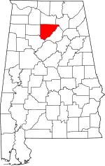 Map of Alabama highlighting Cullman County | |
| Towns | ||
| CDPs | ||
| Unincorporated communities | ||
| Footnotes | ‡This populated place also has portions in an adjacent county or counties | |
This article is issued from Wikipedia. The text is licensed under Creative Commons - Attribution - Sharealike. Additional terms may apply for the media files.