Iselsberg-Stronach | |
|---|---|
 Coat of arms | |
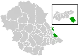
 Location within Lienz district | |
 Iselsberg-Stronach Location within Austria | |
| Coordinates: 46°50′01″N 12°50′52″E / 46.83361°N 12.84778°E | |
| Country | Austria |
| State | Tyrol |
| District | Lienz |
| Government | |
| • Mayor | Jannick Bernsteiner |
| Area | |
| • Total | 17.96 km2 (6.93 sq mi) |
| Elevation | 1,117 m (3,665 ft) |
| Population (2018-01-01)[2] | |
| • Total | 596 |
| • Density | 33/km2 (86/sq mi) |
| Time zone | UTC+1 (CET) |
| • Summer (DST) | UTC+2 (CEST) |
| Postal code | 9991 |
| Area code | 04852 |
| Vehicle registration | LZ |
Iselsberg-Stronach is a municipality in the district of Lienz in Austrian state of Tyrol.
Population
| Year | Pop. | ±% |
|---|---|---|
| 1869 | 334 | — |
| 1880 | 352 | +5.4% |
| 1890 | 308 | −12.5% |
| 1900 | 287 | −6.8% |
| 1910 | 300 | +4.5% |
| 1923 | 283 | −5.7% |
| 1934 | 314 | +11.0% |
| 1939 | 351 | +11.8% |
| 1951 | 395 | +12.5% |
| 1961 | 409 | +3.5% |
| 1971 | 490 | +19.8% |
| 1981 | 458 | −6.5% |
| 1991 | 501 | +9.4% |
| 2001 | 570 | +13.8% |
| 2011 | 617 | +8.2% |
Climate
The Köppen Climate Classification subtype for this climate is Dfc/Dfb (continental subarctic climate), bordering extremely closely on a humid continental climate.[3]
| Climate data for Iselsberg | |||||||||||||
|---|---|---|---|---|---|---|---|---|---|---|---|---|---|
| Month | Jan | Feb | Mar | Apr | May | Jun | Jul | Aug | Sep | Oct | Nov | Dec | Year |
| Record high °C (°F) | 12.9 (55.2) |
15.8 (60.4) |
19.5 (67.1) |
22.5 (72.5) |
26.4 (79.5) |
28.6 (83.5) |
32.4 (90.3) |
30.2 (86.4) |
27.4 (81.3) |
22.4 (72.3) |
18.4 (65.1) |
15.2 (59.4) |
32.4 (90.3) |
| Average high °C (°F) | 1.7 (35.1) |
3.3 (37.9) |
6.6 (43.9) |
10.4 (50.7) |
15.4 (59.7) |
18.7 (65.7) |
21.5 (70.7) |
21.1 (70.0) |
17.4 (63.3) |
11.8 (53.2) |
5.2 (41.4) |
1.9 (35.4) |
11.3 (52.3) |
| Daily mean °C (°F) | −4.1 (24.6) |
−3.2 (26.2) |
0.4 (32.7) |
4.1 (39.4) |
9.2 (48.6) |
12.3 (54.1) |
14.6 (58.3) |
14.0 (57.2) |
10.2 (50.4) |
5.3 (41.5) |
−0.2 (31.6) |
−3.1 (26.4) |
5.0 (41.0) |
| Average low °C (°F) | −8.1 (17.4) |
−7.5 (18.5) |
−3.9 (25.0) |
−0.5 (31.1) |
3.8 (38.8) |
6.6 (43.9) |
8.8 (47.8) |
8.5 (47.3) |
5.3 (41.5) |
1.4 (34.5) |
−3.7 (25.3) |
−6.7 (19.9) |
0.3 (32.5) |
| Record low °C (°F) | −24.1 (−11.4) |
−20.2 (−4.4) |
−18.8 (−1.8) |
−12.6 (9.3) |
−7.6 (18.3) |
−1.7 (28.9) |
−0.4 (31.3) |
−1.1 (30.0) |
−5.1 (22.8) |
−13.3 (8.1) |
−16.6 (2.1) |
−24.9 (−12.8) |
−24.9 (−12.8) |
| Average precipitation mm (inches) | 31.4 (1.24) |
30.2 (1.19) |
43.1 (1.70) |
53.0 (2.09) |
89.4 (3.52) |
105.6 (4.16) |
134.6 (5.30) |
116.7 (4.59) |
98.0 (3.86) |
100.7 (3.96) |
76.9 (3.03) |
52.4 (2.06) |
932.0 (36.69) |
| Average snowfall cm (inches) | 40.4 (15.9) |
41.1 (16.2) |
42.1 (16.6) |
17.6 (6.9) |
7.5 (3.0) |
0.0 (0.0) |
0.0 (0.0) |
0.0 (0.0) |
0.0 (0.0) |
5.4 (2.1) |
38.3 (15.1) |
45.0 (17.7) |
237.4 (93.5) |
| Source: Weatherbase | |||||||||||||
References
Wikimedia Commons has media related to Iselsberg-Stronach.
- ↑ "Dauersiedlungsraum der Gemeinden Politischen Bezirke und Bundesländer - Gebietsstand 1.1.2018". Statistics Austria. Retrieved 10 March 2019.
- ↑ "Einwohnerzahl 1.1.2018 nach Gemeinden mit Status, Gebietsstand 1.1.2018". Statistics Austria. Retrieved 9 March 2019.
- ↑ Climate Summary for Iselsberg-Stronach
This article is issued from Wikipedia. The text is licensed under Creative Commons - Attribution - Sharealike. Additional terms may apply for the media files.