Huxford, Alabama | |
|---|---|
 Huxford  Huxford | |
| Coordinates: 31°13′13″N 87°27′43″W / 31.22028°N 87.46194°W | |
| Country | United States |
| State | Alabama |
| County | Escambia |
| Elevation | 335 ft (102 m) |
| Population | |
| • Total | 197 |
| Time zone | UTC-6 (Central (CST)) |
| • Summer (DST) | UTC-5 (CDT) |
| ZIP code | 36543 |
| Area code | 251 |
| GNIS feature ID | 151842[1] |
Huxford is an unincorporated community in Escambia County, Alabama, United States. Huxford is located near Alabama State Route 21, 13.7 miles (22.0 km) north of Atmore. Huxford had a post office until November 5, 2011; it still has its own ZIP code, 36543.[2][3] Huxford is located along the route of the Federal Road.[4] Huxford has a population of 197 people.[5]
References
- ↑ "Huxford". Geographic Names Information System. United States Geological Survey, United States Department of the Interior.
- ↑ United States Postal Service (2012). "USPS - Look Up a ZIP Code". Retrieved February 15, 2012.
- ↑ "Postmaster Finder - Post Offices by ZIP Code". United States Postal Service. Archived from the original on April 28, 2019. Retrieved February 9, 2013.
- ↑ Braund, Kathryn; Waselkov, Gregory; Christopher, Raven (2019). The Old Federal Road in Alabama. Tuscaloosa: University of Alabama Press. p. 124. ISBN 978-0-8173-5930-0.
- ↑ "Best Places to Live in Huxford (zip 36543), Alabama". Bestplaces.net. Retrieved September 7, 2022.
Municipalities and communities of Escambia County, Alabama, United States | ||
|---|---|---|
| Cities | 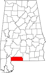 Map of Alabama highlighting Escambia County | |
| Towns | ||
| Unincorporated communities | ||
| Indian reservation | ||
| Former Town | ||
| Footnotes | ‡This populated place also has portions in an adjacent county or counties | |
This article is issued from Wikipedia. The text is licensed under Creative Commons - Attribution - Sharealike. Additional terms may apply for the media files.