| Hartismere | |
|---|---|
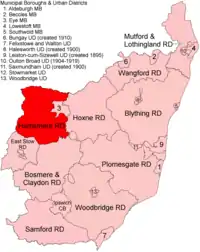 Location within West Suffolk, 1894 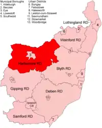 Extended boundaries, 1934 | |
| History | |
| • Created | 1894 |
| • Abolished | 1974 |
| • Succeeded by | Mid Suffolk District |
| Status | Rural district |
| • HQ | Eye |
Hartismere Rural District was a rural district in the county of East Suffolk, England. It was expanded in 1934 by merging with the disbanded Hoxne Rural District with a slight readjustment of boundaries.[1] It was named after the ancient Hundred of Hartismere and administered from Eye.
Since 1 April 1974 it has formed part of the District of Mid Suffolk.
At the time of its dissolution it consisted of 52 civil parishes.
Statistics
| Year | Area[2] | Population [3] |
Density (pop/ha) | |
|---|---|---|---|---|
| acres | ha | |||
| 1911 | 50,100 | 20,275 | 11,485 | 0.57 |
| 1921 | 10,840 | 0.53 | ||
| 1931 | 10,405 | 0.51 | ||
| 1951 | 96,486 | 39,047 | 17,317 | 0.44 |
| 1961 | 16,169 | 0.41 | ||
Parishes
| Parish | From | Notes |
|---|---|---|
| Aspall | ||
| Athelington | 1934 | From Hoxne RD |
| Bacton | ||
| Bedfield | 1934 | From Hoxne RD |
| Bedingfield | 1934 | From Hoxne RD |
| Botesdale | ||
| Braiseworth | ||
| Brome | ||
| Brundish | 1934 | From Hoxne RD |
| Burgate | ||
| Cotton | ||
| Denham | 1934 | From Hoxne RD |
| Finningham | ||
| Fressingfield | 1934 | From Hoxne RD |
| Gislingham | ||
| Horham | 1934 | From Hoxne RD |
| Hoxne | 1934 | From Hoxne RD |
| Kenton | 1934 | From Plomesgate RD |
| Laxfield | 1934 | From Hoxne RD |
| Mellis | ||
| Mendham | 1934 | From Hoxne RD |
| Mendlesham | ||
| Metfield | 1934 | From Hoxne RD |
| Monk Soham | 1934 | From Hoxne RD |
| Oakley | ||
| Occold | ||
| Palgrave | ||
| Redgrave | ||
| Redlingfield | ||
| Rickinghall Superior | ||
| Rishangles | ||
| Southolt | 1934 | From Hoxne RD |
| Stoke Ash | ||
| Stradbroke | 1934 | From Hoxne RD |
| Stuston | ||
| Syleham | 1934 | From Hoxne RD |
| Tannington | 1934 | From Hoxne RD |
| Thorndon | ||
| Thornham Magna | ||
| Thornham Parva | ||
| Thrandeston | ||
| Thwaite | ||
| Westhorpe | ||
| Wetheringsett | ||
| Weybread | 1934 | From Hoxne RD |
| Wickham Skeith | ||
| Wilby | 1934 | From Hoxne RD |
| Wingfield | 1934 | From Hoxne RD |
| Worlingworth | 1934 | From Hoxne RD |
| Wortham | ||
| Wyverstone | ||
| Yaxley |
References
- ↑ "Hartismere RD through time: Census tables with data for the Local Government District". A Vision of Britain through Time. GB Historical GIS / University of Portsmouth. Retrieved 9 July 2017.
- ↑ "Hartismere RD through time: Population Statistics: Area (acres)". A Vision of Britain through Time. GB Historical GIS / University of Portsmouth. Retrieved 9 July 2017.
- ↑ "Hartismere RD through time: Population Statistics: Total Population". A Vision of Britain through Time. GB Historical GIS / University of Portsmouth. Retrieved 9 July 2017.
52°17′N 1°16′E / 52.28°N 1.27°E
| Pre-1974 |
| ||||||
|---|---|---|---|---|---|---|---|
| Post-1974 | |||||||
This article is issued from Wikipedia. The text is licensed under Creative Commons - Attribution - Sharealike. Additional terms may apply for the media files.