Hanksville, Vermont | |
|---|---|
 Hanksville  Hanksville | |
| Coordinates: 44°15′9″N 72°57′37″W / 44.25250°N 72.96028°W | |
| Country | United States |
| State | Vermont |
| County | Chittenden |
| Town | Huntington |
| Area | |
| • Total | 0.13 sq mi (0.34 km2) |
| • Land | 0.13 sq mi (0.34 km2) |
| • Water | 0.0 sq mi (0.0 km2) |
| Elevation | 840 ft (260 m) |
| Time zone | UTC-5 (Eastern (EST)) |
| • Summer (DST) | UTC-4 (EDT) |
| ZIP Code | 05462 (Huntington) |
| Area code | 802 |
| FIPS code | 50-31600 |
| GNIS feature ID | 2807134[2] |
Hanksville is an unincorporated village and census-designated place (CDP) in the town of Huntington, Chittenden County, Vermont, United States. It was first listed as a CDP prior to the 2020 census.
The village is in southeastern Chittenden County, in the southern part of the town of Huntington, in the valley of the Huntington River, a north-flowing tributary of the Winooski River. The main ridge of the Green Mountains rises to the east, running from 3,160-foot (960 m) Burnt Rock Mountain in the north to 2,967-foot (904 m) Molly Stark Mountain in the south. Main Road runs the length of the community, following the Huntington River; it leads north 3.5 miles (5.6 km) to Huntington Center and south 2.5 miles (4.0 km) to Vermont Route 17 at the western base of Appalachian Gap.
References
- ↑ "2020 U.S. Gazetteer Files – Vermont". United States Census Bureau. Retrieved October 6, 2021.
- ↑ "Hanksville Census Designated Place". Geographic Names Information System. United States Geological Survey, United States Department of the Interior.
Municipalities and communities of Chittenden County, Vermont, United States | ||
|---|---|---|
| Cities | 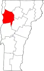 Map of Vermont highlighting Chittenden County | |
| Towns | ||
| Villages | ||
| CDPs | ||
| Unincorporated communities | ||