Hajjilar-e Shomali Rural District
Persian: دهستان حاجیلار شمالی | |
|---|---|
 Hajjilar-e Shomali Rural District | |
| Coordinates: 38°56′22″N 45°06′56″E / 38.93944°N 45.11556°E[1] | |
| Country | |
| Province | West Azerbaijan |
| County | Chaypareh |
| District | Hajjilar |
| Population (2016)[2] | |
| • Total | 2,579 |
| Time zone | UTC+3:30 (IRST) |
Hajjilar-e Shomali Rural District (Persian: دهستان حاجیلار شمالی)[3] is in Hajjilar District of Chaypareh County, West Azerbaijan province, Iran.[4]
After the 2006 National Census, Chaypareh District was separated from Khoy County in the establishment of Chaypareh County, which was divided into two districts of two rural districts each, with the city of Qarah Zia od Din as its capital and only city.
There were 2,652 inhabitants in 672 households at the following census of 2011.[5] At the most recent census of 2016, the population of the rural district was 2,579 in 693 households. The largest of its 27 villages was Shirin Bolagh, with 653 people.[2]
References
- ↑ OpenStreetMap contributors (5 March 2023). "Hajjilar-e Shomali Rural District (Chaypareh County)" (Map). OpenStreetMap. Retrieved 5 March 2023.
- 1 2 "Census of the Islamic Republic of Iran, 1395 (2016)". AMAR (in Persian). The Statistical Center of Iran. p. 04. Archived from the original (Excel) on 30 August 2022. Retrieved 19 December 2022.
- ↑ Iranian National Committee for Standardization of Geographical Names website (in Persian)
- ↑ Davodi, Parviz. "Approval letter regarding reforms of country divisions in West Azerbaijan province". Ministry of Interior. Archived from the original on 10 February 2015. Retrieved 12 November 2023.
- ↑ "Census of the Islamic Republic of Iran, 1390 (2011)" (Excel). Iran Data Portal (in Persian). The Statistical Center of Iran. p. 04. Retrieved 19 December 2022.
West Azerbaijan province, Iran | ||
|---|---|---|
| Capital | 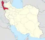 | |
| Counties and cities | ||
| Tourism | ||
| Places | ||
| Capital | |||||||||||||||||||||
|---|---|---|---|---|---|---|---|---|---|---|---|---|---|---|---|---|---|---|---|---|---|
| Districts |
| ||||||||||||||||||||
This article is issued from Wikipedia. The text is licensed under Creative Commons - Attribution - Sharealike. Additional terms may apply for the media files.