Hörbranz | |
|---|---|
 | |
 Coat of arms | |
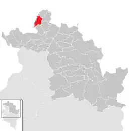 Location in the district | |
 Hörbranz Location within Austria | |
| Coordinates: 47°33′00″N 09°45′00″E / 47.55000°N 9.75000°E | |
| Country | Austria |
| State | Vorarlberg |
| District | Bregenz |
| Government | |
| • Mayor | Karl Hehle (ÖVP) |
| Area | |
| • Total | 8.74 km2 (3.37 sq mi) |
| Elevation | 426 m (1,398 ft) |
| Population (2018-01-01)[2] | |
| • Total | 6,346 |
| • Density | 730/km2 (1,900/sq mi) |
| Time zone | UTC+1 (CET) |
| • Summer (DST) | UTC+2 (CEST) |
| Postal code | 6912 |
| Area code | 05573 |
| Vehicle registration | B |
| Website | www.hoerbranz.at |
Hörbranz is a municipality in the district of Bregenz in the Austrian state of Vorarlberg.
Population
| Year | Pop. | ±% |
|---|---|---|
| 1869 | 1,174 | — |
| 1880 | 1,190 | +1.4% |
| 1890 | 1,317 | +10.7% |
| 1900 | 1,456 | +10.6% |
| 1910 | 1,672 | +14.8% |
| 1923 | 1,816 | +8.6% |
| 1934 | 2,017 | +11.1% |
| 1939 | 1,959 | −2.9% |
| 1951 | 2,523 | +28.8% |
| 1961 | 3,260 | +29.2% |
| 1971 | 4,541 | +39.3% |
| 1981 | 4,997 | +10.0% |
| 1991 | 5,566 | +11.4% |
| 2001 | 6,153 | +10.5% |
| 2011 | 6,288 | +2.2% |
References
- ↑ "Dauersiedlungsraum der Gemeinden Politischen Bezirke und Bundesländer - Gebietsstand 1.1.2018". Statistics Austria. Retrieved 10 March 2019.
- ↑ "Einwohnerzahl 1.1.2018 nach Gemeinden mit Status, Gebietsstand 1.1.2018". Statistics Austria. Retrieved 9 March 2019.
Wikimedia Commons has media related to Hörbranz.
This article is issued from Wikipedia. The text is licensed under Creative Commons - Attribution - Sharealike. Additional terms may apply for the media files.