Gveleti
Gelatē | |
|---|---|
Village | |
_in_1902.jpg.webp)  View of Gveleti: 1902 and 2010 | |
 Gveleti Location of Gveleti in Georgia  Gveleti Gveleti (Republic of Ingushetia)  Gveleti Gveleti (Mtskheta-Mtianeti) | |
| Coordinates: 42°42′26″N 44°37′25″E / 42.70722°N 44.62361°E | |
| Country | |
| Mkhare | Mtskheta-Mtianeti |
| Municipality | Kazbegi |
| Elevation | 1,560 m (5,120 ft) |
| Population (2014)[1] | |
| • Total | 2 |
| Time zone | UTC+4 (Georgian Time) |
Gveleti (Georgian: გველეთი; Ingush: Гелате, romanized: Gelate), is a village (aul) in the Kazbegi Municipality of Georgia. It is located in the Darial Gorge, on the right bank of the Devdaraki (a left tributary of the Terek river), 4 km from the border with Russia. Gelatē was founded by the Ingush taïp Gelatkhoy (Ingush: Гелатхой).
History
_on_G%C3%BCldenst%C3%A4dt's_map.jpg.webp)
._19th_century.jpg.webp)
.jpg.webp)
The first mention of Gveleti occurred in the document «Gergetis sulta matiane» dating to the 15th century.[2] In Russian documents the village is first mentioned in 1589 in the Ambassadorial Orders under the name "Cherebashev kabak" (settlement), named after the elder of the Ingush village — Cherbash (Ingush: ЧӀербаж). During the passage of the Russian embassy led by S. Zvenigorodsky and T. Antonov through the territory of the Ingush to Georgia in September 1589, the rains washed away the last bridge across the river on the border with Georgia, and the embassy was forced to ask for help from local residents. They were in need of wood to repair the bridge as was documented: “the ambassadors, Prince Semyon and Deacon Torkh, at the Cherebashov kabak, spend a day for the bridge”.[3][4]
The Cherebashev settlement was located on the site of the Ingush village of Gvileti in the Darial Gorge. According to Ingush historical legends, the ancestors of the Cherbizhev's (Чербижевы) lived along the areas of the Georgian Military Road. In one of these legends, written down by B.K. Dalgat, it is said that Cherbizh (Чербыш) and the inhabitants of Gvileti managed to defeat the army of the Kabardian knyaz, who was marching on Tiflis.[5][6] In gratitude for this, the Georgian king George presented Cherbizh with land from Kazbeki to Gvileti.[7][8]
Historically Gveleti was part of the Metskhalin society, also known as the Kistin or Fyappiy society.[9]
Geography
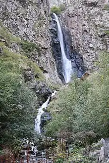
Gveleti is located 1560 meters above sea level, 9 kilometers from Stepantsminda. It is the first residential settlement after the Dariali Border Checkpoint.[10] The Geveleti waterfalls can be found near the village; the water from the bigger one cascades from a small river called Gveletistskali. The force of the stream has carved out a bowl-shaped depression in the rock, which makes the waterfall very beautiful. Not far from the Gveleti Big Waterfall there is a smaller waterfall and a lake; together these natural objects form a single complex. The Gveleti Small Waterfall is located closer to the village. The height of the Gveleti Big Waterfall reaches up to 25 meters. The width of the water flow reaches 4 meters, and the width of the top is 2 meters.[11]
References
- ↑ "მოსახლეობის საყოველთაო აღწერა 2014". საქართველოს სტატისტიკის ეროვნული სამსახური. November 2014. Archived from the original on 11 November 2020. Retrieved 27 July 2016.
- ↑ "Landscape Investigations in the Dariali Pass" (PDF). Durham University. 10 December 2019. p. 11.
- ↑ Кушева Е.Н. «Народы Северного Кавказа и их связи с Россией (вторая половина XVI — 30-е годы XVII века)» / Ред. изд-ва И.У. Будовниц. — Утверждено Институтом истории АН СССР. — М. : Изд-во АН СССР, 1963.
- ↑ Книга посольских приказов. "1589 г. августа 21 — октябрь. — Из статейного списка русских послов в Кахетию князя С.Г. Звенигородского и дьяка Т. Антонова об их переговорах в Терском городе и на Суншинском городище с окоцким мурзой Шихом, об их пути от городища в Кахетию через Дарьяльское ущелье, о переговорах с мурзой Ларсова кабака Салтаном и др" (in Russian). Archived from the original on 26 January 2021. Retrieved 12 September 2020.
- ↑ ЦГАДА, ф. Грузинские дела, 1589, № 1, л. 203-383. Копия XV в. Опубликовано: Белокуров С.А. Сношения России с Кавказом / с. 127-154.
- ↑ Этнографическое обозрение. №1, Москва, 1901 г. / с. 63
- ↑ Волкова Н.Г. «Этнический состав населения Северного Кавказа в XVIII — начале XX в.» Москва, 1974 г. / с. 146
- ↑ Волкова Н.Г. «Этнонимы и племенные названия Северного Кавказа.» Москва: Наука, 1973 г. / с. 156-157
- ↑ Вильямс 1928, p. 101.
- ↑ "Ущелье Дарьяли и водопады Гвелети". VirtualTravel (in Russian). 8 January 2019.
- ↑ "Гвелетский водопад (Gveleti Waterfall)". Туристер (in Russian). 24 May 2023.
Bibliography
- Вильямс, А. К. (1928). Географический очерк Ингушетии [Geographical essay of Ingushetia] (in Russian). Владикавказ: Отдел народного образования Ингушской Автономной Области. pp. 1–128.