.jpg.webp)
The geology of the Canary Islands is dominated by volcanic rock. The Canary Islands and some seamounts to the north-east form the Canary Volcanic Province whose volcanic history started about 70 million years ago.[1] The Canary Islands region is still volcanically active. The most recent volcanic eruption on land occurred in 2021[2] and the most recent underwater eruption was in 2011-12.[1]
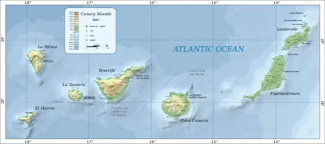
The Canary Islands are a 450 km (280 mi) long, east-west trending, archipelago of volcanic islands in the North Atlantic Ocean, 100–500 km (62–311 mi) off the coast of Northwest Africa.[3] The islands are located on the African tectonic plate. The Canary Islands are an example of intraplate volcanism because they are located far (more than 600 km (370 mi)) from the edges of the African Plate.[4]
From east to west, the main islands are Lanzarote, Fuerteventura, Gran Canaria, Tenerife, La Gomera, La Palma, and El Hierro.[Note 1] There are also several minor islands and islets. The seven main Canary Islands originated as separate submarine seamount volcanoes on the floor of the Atlantic Ocean, which is 1,000–4,000 m (3,300–13,100 ft) deep in the Canarian region.
Lanzarote and Fuerteventura are parts of a single volcanic ridge called the Canary Ridge. These two present-day islands were a single island in the past. Part of the ridge has been submerged and now Lanzarote and Fuerteventura are separate islands, separated by an 11 km (6.8 mi) wide, 40 m (130 ft) deep strait of ocean water.[6]
Volcanic activity has occurred during the last 11,700 years on all of the main islands except La Gomera.[7]
Growth stages
Volcanic oceanic islands, such as the Canary Islands, form in deep parts of the oceans. This type of island forms by a sequence of development stages:[8]
- (1) submarine (seamount) stage
- (2) shield-building stage
- (3) declining stage (La Palma and El Hierro)
- (4) erosion stage (La Gomera)
- (5) rejuvenation/post-erosional stage (Fuerteventura, Lanzarote, Gran Canaria and Tenerife).[8]
The Canary Islands differ from some other volcanic oceanic islands, such as the Hawaiian Islands, in several ways – for example, the Canary Islands have stratovolcanoes, compression structures and a lack of subsidence.[8]
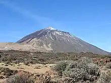
The seven main Canary Islands originated as separate submarine seamount volcanoes on the floor of the Atlantic Ocean. Each seamount, built up by the eruption of many lava flows, eventually became an island. Subaerial volcanic eruptions continued on each island. Fissure eruptions dominated on Lanzarote and Fuerteventura, resulting in relatively subdued topography with heights below 1,000 m (3,300 ft). The other islands are much more rugged and mountainous. In the case of Tenerife, the volcanic edifice of Teide rises about 7,500 m (24,600 ft) above the ocean floor (about 3,780 m (12,400 ft) underwater and 3,715 m (12,188 ft) above sea level).[9][10]
Age
The age of the oldest subaerially-erupted lavas on each island decreases from east to west along the island chain: Lanzarote-Fuerteventura (20.2 Ma), Gran Canaria (14.6 Ma), Tenerife (11.9 Ma), La Gomera (9.4 Ma), La Palma (1.7 Ma) and El Hierro (1.1 Ma).[11][4]
Rock types
Volcanic rock types found on the Canary Islands are typical of oceanic islands. The volcanic rocks include alkali basalts, basanites, phonolites, trachytes, nephelinites, trachyandesites, tephrites and rhyolites.[8][7]
Outcrops of plutonic rocks (for example, syenites, gabbros and pyroxenites) occur on Fuerteventura,[12] La Gomera and La Palma. Apart from some islands of Cape Verde (another island group in the Atlantic Ocean, about 1,400 km (870 mi) south-west of the Canary Islands), Fuerteventura is the only oceanic island known to have outcrops of carbonatite.[13]
Volcanic landforms
Examples of the following types of volcanic landforms occur in the Canary Islands: shield volcano, stratovolcano, collapse caldera, erosion caldera, cinder cone, coulee, scoria cone, tuff cone, tuff ring, maar, lava flow, lava flow field, dyke, volcanic plug.[14]
Origins of volcanism
Several hypotheses have been proposed to explain the volcanism of the Canary Islands.[15] Two hypotheses have received the most attention from geologists:
- The volcanism is related to crustal fractures extending from the Atlas Mountains of Morocco.
- The volcanism is caused by the African Plate moving slowly over a hotspot in the Earth's mantle.
Currently, a hotspot is the explanation accepted by most geologists who study the Canary Islands.[16][17]
Volcanic eruption distribution
Seventy-five confirmed volcanic eruptions have occurred in the Canary Islands in the Holocene Epoch (the last 11,700 years of Earth's geological history).[18] Sixteen of these eruptions have been during the Modern Era of European history (that is, after c.1480).[19] Therefore, in the last 500 years, volcanic eruptions have occurred, on average, every 30 to 35 years.[20] However, in the Modern Era, the repose period between infrequent eruptions at each volcano has been highly variable (26 to 237 years for Cumbre Vieja on La Palma; 1 to 212 years on Tenerife), making reliable prediction of future eruptions unlikely.[21][22]
| Island | Holocene (last 11,700 years) | Modern Era (since c. 1480) | Modern Era eruption dates | Notes | Reference |
|---|---|---|---|---|---|
| Lanzarote | 4 | 2 | 1730–1736, 1824 | [23] | |
| Fuerteventura | 0 | 0 | —— | No specific confirmed Holocene eruptions but Holocene eruptions are inferred by freshness of lava and volcanic landforms | [24] |
| Gran Canaria | 11 | 0 | —— | [25] | |
| Tenerife | 42 | 5 | 1492, 1704–1705, 1706, 1798, 1909 | [26] | |
| La Gomera | 0 | 0 | —— | [27] | |
| La Palma | 14 | 8 | 1481(±11), 1585, 1646, 1677–1678, 1712, 1949, 1971, 2021 | [28] | |
| El Hierro | 4 | 1 | 2011–2012 | [29] |
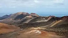
Lanzarote

Volcanic activity at Lanzarote started during the Oligocene Epoch at 28 Ma.[30] For the about first 12 million years, the lava pile of a submarine seamount built up from the 2,500 m deep sea floor.[31] Then, in the Miocene Epoch, from 15.6 Ma to 12 Ma, the Los Ajaches subaerial shield volcano grew as an island on top of the seamount, in an area corresponding to present-day southern Lanzarote.[32] Between 10.2 Ma and 3.8 Ma, volcanic activity was focussed about 35 km to the northeast, forming a second shield volcanic island called Famara.[33] Between Los Ajaches and Famara volcanoes, a central volcanic edifice was also active from 6.6 to 6.1 Ma.[34] The edifices gradually merged to form a single island, Lanzarote, at about 4 Ma.[35] From 3.9 Ma to 2.7 Ma, volcanic activity paused and the island was eroded.[36] Today, although the lavas of Los Ajaches volcano are now mostly covered by calcrete,[37] the eroded remains of the two shield volcanoes are preserved in southern and northern Lanzarote respectively, with small outcrops of the central edifice occurring between them. At about 2.7 Ma, in the late Pliocene Epoch, the rejuvenation stage began. It produced much less lava than the earlier shield stage, mainly at the Montaña Roja and Montaña Bermeja volcanoes in southern Lanzarote.[36] Then, throughout the subsequent Pleistocene and Holocene epochs, the rejuvenation volcanism has continued and has been dominated by strombolian-style eruptions of lava from sets of volcanic cones aligned along numerous NE-SW fissures in the central part of Lanzarote.[38] The rejuvenation stage has included eruptions at Montaña Corona (about 21,000 years ago), Timanfaya (1730-1736) and Tao/Nuevo del Fuego/Tinguatón (1824).[39][40][41]
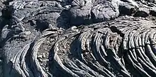
The Timanfaya eruption (1730–1736) erupted more than one billion cubic metres (1 km3) of lava, and a large volume of pyroclastic tephra, from more than 30 volcanic vents along a 14 km-long fissure in western Lanzarote. The lava flows covered one quarter of the island (an area of about 225 km2) with some of the flows reaching about 50 m in thickness. It is the largest Modern Era eruption in the Canary Islands, and the third largest eruption of basaltic lava on Earth in historical times.[42][43][44][45][46]
Almost all the volcanic rocks of Lanzarote are basaltic.[47]
Earthquakes
The seismicity of the Canary Islands is low. Earthquakes that occur on or near the Canary Islands are linked to volcanism and tectonism. Most earthquakes in the region have had an intensity of VI or less on the Modified Mercalli Scale. The Timanfaya eruptions on Lanzarote in 1730, however, were accompanied by earthquakes with intensities of up to X on the same scale.[48]
See also
Further reading
- Juan Carlos Carracedo, Simon Day: Canary Islands. Classic Geology of Europe 4. Harpenden 2002.
Notes
- ↑ Since 2018, La Graciosa has been officially designated "la octava isla canaria habitada"[5] (the eighth inhabited island of the Canary Islands), in effect the eighth "main island". This is only a political and social designation. La Graciosa continues to be a geologically minor island of the Canary Islands, associated with its much larger neighbour Lanzarote.
References
- 1 2 Carracedo, J.C.; Troll, V.R.; Zaczek, K.; Rodríguez-González, A.; Soler, V.; Deegan, F.M. (2015) The 2011–2012 submarine eruption off El Hierro, Canary Islands: New lessons in oceanic island growth and volcanic crisis management, Earth-Science Reviews, volume 150, pages 168–200, doi:10.1016/j.earscirev.2015.06.007
- ↑ "Lava shoots up from volcano on La Palma in Spanish Canary Islands". Reuters. 2021-09-19. Retrieved 2021-09-19.
- ↑ Schmincke, H.U. and Sumita, M. (1998) Volcanic Evolution of Gran Canaria reconstructed from Apron Sediments: Synthesis of VICAP Project Drilling in Weaver, P.P.E., Schmincke, H.U., Firth, J.V., and Duffield, W. (editors) (1998) Proceedings of the Ocean Drilling Program, Scientific Results, volume 157
- 1 2 Carracedo, Juan Carlos; Troll, Valentin R. (2021-01-01), "North-East Atlantic Islands: The Macaronesian Archipelagos", in Alderton, David; Elias, Scott A. (eds.), Encyclopedia of Geology (Second Edition), Oxford: Academic Press, pp. 674–699, doi:10.1016/b978-0-08-102908-4.00027-8, ISBN 978-0-08-102909-1, S2CID 226588940, retrieved 2021-03-16
- ↑ "El Senado reconoce a La Graciosa como la octava isla canaria habitada". El País (in Spanish). 26 June 2018. Retrieved 4 December 2019.
- ↑ Carracedo, J.C. and Troll, V.R. (2016) The Geology of the Canary Islands, Amsterdam, Elsevier, ISBN 978-0-12-809663-5, page 532
- 1 2 Tanguy, J-C. and Scarth, A. (2001) “Volcanoes of Europe”, Harpenden, Terra Publishing, ISBN 1-903544-03-3, page 101
- 1 2 3 4 Viñuela, J.M. (2007). "The Canary Islands Hot Spot" (PDF). www.mantleplumes.org. Archived (PDF) from the original on 18 August 2019. Retrieved 30 November 2019.
- ↑ Hoernle, K. and Carracedo, J.C. Canary Islands, Geology in Gillespie, R. and Clague, D. (editors) (2009) Encyclopedia of Islands, page 134
- ↑ Martínez-García, E. Spain in Moores, E.M. and Fairbridge, R. (editors) (1997) Encyclopedia of European and Asian Regional Geology, London, Chapman and Hall, ISBN 0-412740-400, page 680
- ↑ Carracedo, J.C and Troll, V.R. (editors) (2013) “Teide Volcano:Geology and Eruptions of a Highly Differentiated Oceanic Stratovolcano”, Berlin, Springer-Verlag, ISBN 978-3-642-25892-3, Page 24
- ↑ Hoernle, K. and Carracedo, J.C. Canary Islands, Geology in Gillespie, R. and Clague, D. (editors) (2009) Encyclopedia of Islands, page 140
- ↑ Bell, K. and Tilton, G.R. (2002) Probing The Mantle: The Story From Carbonatites, EOS, Volume 83, Number 25, pages 273-280 https://agupubs.onlinelibrary.wiley.com/doi/pdf/10.1029/2002EO000190 Archived 2021-09-20 at the Wayback Machine
- ↑ Tanguy, J-C. and Scarth, A. (2001) Volcanoes of Europe. Harpenden, Terra Publishing, ISBN 1-903544-03-3, page 100
- ↑ Vonlanthen, P., Kunze, K., Burlini, L. and Grobety, B. (2006) Seismic properties of the upper mantle beneath Lanzarote (Canary Islands): Model predictions based on texture measurements by EBSD, Tectonophysics, volume 428, pages 65-85, doi:10.1016/j.tecto.2006.09.005
- ↑ Yepes, J.A. (2007). "The Canary Islands Topobathymetric Relief Map - Aspect Of The Sea Bed And Geology" (PDF). Spanish Institute of Oceanography (IEO). Retrieved 25 July 2018.
- ↑ Weis, F.A.; Skogby, H.; Troll, V.R.; Deegan, F.M.; Dahren, B. (2015). "Magmatic water contents determined through clinopyroxene: Examples from the Western Canary Islands, Spain". Geochemistry, Geophysics, Geosystems. 16 (7): 2127–2146. doi:10.1002/2015GC005800. hdl:10553/72171. S2CID 128390629.
- ↑ Spain Volcanoes – Smithsonian Institution Global Volcanism Program, retrieved 26 November 2023; https://volcano.si.edu/volcanolist_countries.cfm?country=Spain
- ↑ Spain Volcanoes – Smithsonian Institution Global Volcanism Program, retrieved 26 November 2023; https://volcano.si.edu/volcanolist_countries.cfm?country=Spain
- ↑ Tanguy, J-C. and Scarth, A. (2001) "Volcanoes of Europe", Harpenden, Terra Publishing, ISBN=1-903544-03-3, page 101
- ↑ Hoernle, K. and Carracedo, J.C. "Canary Islands, Geology" in Gillespie, R. and Clague, D. (editors) (2009) "Encyclopedia of Islands", page 135
- ↑ Spain Volcanoes – Smithsonian Institution Global Volcanism Program, retrieved 26 November 2023; https://volcano.si.edu/volcanolist_countries.cfm?country=Spain
- ↑ Lanzarote - Eruption history ; Smithsonian Institution Global Volcanism Program, retrieved 08 Nov 2023; https://volcano.si.edu/volcano.cfm?vn=383060
- ↑ Fuerteventura - Eruption history ; Smithsonian Institution Global Volcanism Program, retrieved 08 Nov 2023; https://volcano.si.edu/volcano.cfm?vn=383050
- ↑ Gran Canaria - Eruption history ; Smithsonian Institution Global Volcanism Program, retrieved 08 Nov 2023; https://volcano.si.edu/volcano.cfm?vn=383040
- ↑ Tenerife - Eruption history ; Smithsonian Institution Global Volcanism Program, retrieved 08 Nov 2023; https://volcano.si.edu/volcano.cfm?vn=383030
- ↑ Tanguy, J-C. and Scarth, A. (2001) "Volcanoes of Europe", Harpenden, Terra Publishing, ISBN 1-903544-03-3, page 101
- ↑ La Palma - Eruption history ; Smithsonian Institution Global Volcanism Program, retrieved 08 Nov 2023; https://volcano.si.edu/volcano.cfm?vn=383010
- ↑ Hierro - Eruption history ; Smithsonian Institution Global Volcanism Program, retrieved 08 Nov 2023; https://volcano.si.edu/volcano.cfm?vn=383020
- ↑ Hansen Machin, A. and Perez Torrado, F. (2005) "The Island and it's Territory: Volcanism in Lanzarote", Sixth International Conference on Geomorphology, Field Trip Guide C-1, page 6
- ↑ Becerril, L. et al. (2017) "Assessing qualitative long-term volcanic hazards at Lanzarote Island (Canary Islands)", Nat. Hazards Earth Syst. Sci., volume 17, pages 1145–1157, doi=10.5194/nhess-17-1145-2017
- ↑ Coello et al. (1992) "Evolution of the eastern volcanic ridge of the Canary Islands based on new K-Ar data", Journal of Volcanology and Geothermal Research, volume 53, pages 251-274
- ↑ Hansen Machin, A. and Perez Torrado, F. (2005) "The Island and it's Territory: Volcanism in Lanzarote", Sixth International Conference on Geomorphology, Field Trip Guide C-1, page 7
- ↑ Instituto Geológico y Minero de España (IGME) Cartográfica de Canarias (GRAFCAN) (2015) "Descripción de las Unidades Geológicas de Lanzarote" for "Mapa Geológico de Canarias", Instituto Geológico y Minero de España; Madrid, Spain: 2015. Gobierno de Canarias, CARTOGRAF, FEDER, Programa MAC 2007–2013, 1992–1994, page 2
- ↑ Hansen Machin, A. and Perez Torrado, F. (2005) "The Island and it's Territory: Volcanism in Lanzarote", Sixth International Conference on Geomorphology, Field Trip Guide C-1, page 8
- 1 2 Instituto Geológico y Minero de España (IGME) Cartográfica de Canarias (GRAFCAN) (2015) "Descripción de las Unidades Geológicas de Lanzarote" for "Mapa Geológico de Canarias", Instituto Geológico y Minero de España; Madrid, Spain: 2015. Gobierno de Canarias, CARTOGRAF, FEDER, Programa MAC 2007–2013, 1992–1994, page 3
- ↑ Carracedo, J.C. and Day, S. (2002) “Canary Islands”, Harpenden, Terra Publishing, ISBN=1-903544-07-6, pages 58
- ↑ Instituto Geológico y Minero de España (IGME) Cartográfica de Canarias (GRAFCAN) (2015) "Descripción de las Unidades Geológicas de Lanzarote" for "Mapa Geológico de Canarias", Instituto Geológico y Minero de España; Madrid, Spain: 2015. Gobierno de Canarias, CARTOGRAF, FEDER, Programa MAC 2007–2013, 1992–1994, pages 3 and 4
- ↑ Carracedo, J.C. and Day, S. (2002) “Canary Islands”, Harpenden, Terra Publishing, ISBN=1-903544-07-6, pages 1–11, 57
- ↑ Hoernle, K. and Carracedo, J-C. “Canary Islands, Geology” in Gillespie, R. and Clague, D. (editors) (2009) “Encyclopedia of Islands”, page 140
- ↑ Lanzarote and Chinijo Archipelago Geopark http://www.geoparquelanzarote.org/geologia/
- ↑ Carracedo, J.C. and Troll, V.R. (2016) "The Geology of the Canary Islands", Amsterdam, Elsevier, ISBN 978-0-12-809663-5, page 486
- ↑ Hoernle, K. and Carracedo, J-C. "Canary Islands, Geology" in Gillespie, R. and Clague, D. (editors) (2009) "Encyclopedia of Islands", page 140
- ↑ Carracedo J.C. and Perez Torrado, F.J. "Cenozoic Volcanism in the Canary Islands: Canarian geochronology, stratigraphy and evolution: an overview" in Gibbons, W. and Moreno, T. (editors) (2002) "Geology of Spain", London, The Geological Society, ISBN =1-86239-110-6, page 463
- ↑ Schmincke, H.U. and Sumita, M. (1998) "Volcanic Evolution of Gran Canaria reconstructed from Apron Sediments: Synthesis of VICAP Project Drilling" in Weaver, P.P.E., Schmincke, H.-U., Firth, J.V., and Duffield, W. (editors) (1998) "Proceedings of the Ocean Drilling Program, Scientific Results", volume 157
- ↑ Padilla, G. et al. (2010) "Diffuse CO2 Emission from Timanfaya Volcano, Lanzarote, Canary Islands, Spain", Cities on Volcanoes - Conference 6 - Abstracts
- ↑ Mitchell-Thomé, Raoul C. (1976) "Geology of the Middle Atlantic Islands", Berlin, Gebrueder Borntraeger, ISBN=3-443-11012-6, pages 170 and 174
- ↑ González de Vallejoa, L.I.; Tsigé, M.; Cabrera, L. (2005) "Paleoliquefaction features on Tenerife (Canary Islands) in Holocene sand deposits", Engineering Geology, volume 76, pages 179–190, doi=10.1016/j.enggeo.2004.07.006