Garmdarreh
Persian: گرمدره | |
|---|---|
Village | |
 Garmdarreh | |
| Coordinates: 32°41′19″N 50°48′59″E / 32.68861°N 50.81639°E[1] | |
| Country | |
| Province | Chaharmahal and Bakhtiari |
| County | Saman |
| District | Zayandehrud |
| Rural District | Zarrin |
| Population (2016)[2] | |
| • Total | 1,315 |
| Time zone | UTC+3:30 (IRST) |
Garmdarreh (Persian: گرمدره)[3] is a village in, and the capital of, Zarrin Rural District of Zayandehrud District, Saman County, Chaharmahal and Bakhtiari province, Iran.[4] The village is populated by Turkic people.[5]
In 2013, Saman District was separated from Shahrekord County in the establishment of Saman County, which was divided into two districts of two rural districts each, with the city of Saman as its capital and only city.[4]
At the 2006 census, its population was 1,104 in 288 households, when it was in Hureh Rural District of the former Saman District of Shahrekord County.[6] The following census in 2011 counted 1,204 people in 386 households.[7] The latest census in 2016 showed a population of 1,315 people in 433 households, by which time the district had been separated from the county in the establishment of Saman County.[4][2]
References
- ↑ OpenStreetMap contributors (2 April 2023). "Garmdarreh, Saman County" (Map). OpenStreetMap. Retrieved 2 April 2023.
- 1 2 "Census of the Islamic Republic of Iran, 1395 (2016)". AMAR (in Persian). The Statistical Center of Iran. p. 14. Archived from the original (Excel) on 24 May 2019. Retrieved 19 December 2022.
- ↑ Garmdarreh can be found at GEOnet Names Server, at this link, by opening the Advanced Search box, entering "-3063614" in the "Unique Feature Id" form, and clicking on "Search Database".
- 1 2 3 Rahimi, Mohammad Reza. "Letter of approval regarding country divisions in Chaharmahal and Bakhtiari province". Islamic Parliament Research Center of the Islamic Republic of Iran (in Persian). Ministry of Interior, Council of Ministers. Archived from the original on 10 January 2013. Retrieved 6 November 2023.
- ↑ "Language distribution: Chahar Mahal va Bakhtiari Province". Iran Atlas. Retrieved 25 March 2021.
- ↑ "Census of the Islamic Republic of Iran, 1385 (2006)". AMAR (in Persian). The Statistical Center of Iran. p. 14. Archived from the original (Excel) on 20 September 2011. Retrieved 25 September 2022.
- ↑ "Census of the Islamic Republic of Iran, 1390 (2011)" (Excel). Iran Data Portal (in Persian). The Statistical Center of Iran. p. 14. Retrieved 19 December 2022.
| Capital | 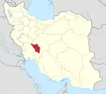 | ||||||||||||||||||||||
|---|---|---|---|---|---|---|---|---|---|---|---|---|---|---|---|---|---|---|---|---|---|---|---|
| Counties and cities |
| ||||||||||||||||||||||
| Landmarks |
| ||||||||||||||||||||||
| populated places | |||||||||||||||||||||||