| Fuchs Dome | |
|---|---|
| Highest point | |
| Elevation | 1,525 m (5,003 ft) |
| Coordinates | 80°36′S 27°50′W / 80.600°S 27.833°W |
| Geography | |
| Location | Coats Land, Antarctica |
| Parent range | Shackleton Range |
Fuchs Dome (80°36′S 27°50′W / 80.600°S 27.833°W) is a large ice-covered dome rising over 1,525 metres (5,000 ft), between Stratton Glacier and Gordon Glacier in the central part of the Shackleton Range, Antarctica. It was first mapped in 1957 by the Commonwealth Trans-Antarctic Expedition (CTAE) and named for Sir Vivian E. Fuchs, leader of the CTAE 1955–58.[1]
Features
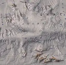
Features surrounding the dome that are named on the 1983 United States Geological Survey map are (clockwise from west):[2]
Stratton Glacier
80°22′S 29°00′W / 80.367°S 29.000°W. A glacier 20 miles (32 km) long, flowing north from Pointer Nunatak and then northwest to the north of Mount Weston, in the Shackleton Range. First mapped in 1957 by the CTAE and named for David G. Stratton, surveyor and deputy leader of the transpolar party of the CTAE in 1956-58.[3]
Lister Heights
80°31′S 28°35′W / 80.517°S 28.583°W. Rock heights on the east side of Stratton Glacier, 4 miles (6.4 km) southwest of Flat Top in the west part of the Shackleton Range. First mapped in 1957 by the CTAE and named for Hal Lister, glaciologist with the transpolar party of the CTAE in 1956-58, and leader at the expedition's advance base, "South Ice," in 1957.[4]
Flat Top
80°27′S 28°16′W / 80.450°S 28.267°W. Distinctive table mountain, 1,330 metres (4,360 ft), with steep rocky cliffs, 4 miles (6.4 km) northeast of Lister Heights in the west part of the Shackleton Range. First seen and given this descriptive name during the early reconnaissance flights of the CTAE, 1955-58. Visited and mapped by the CTAE in 1957.[5]
Petersen Peak
80°27′S 27°57′W / 80.450°S 27.950°W. A rock peak (1,215 metres (3,986 ft)) standing 6 miles (9.7 km) southwest of Morris Hills in the north-central part of Shackleton Range. First mapped in 1957 by the CTAE and named for Hans C. Petersen, captain of the Danish ship Magga Dan which transported members of the CTAE to the Filchner Ice Shelf in 1956-57. Not: Peterson Peak.[6]
Clarkson Cliffs
80°28′S 27°04′W / 80.467°S 27.067°W. Ice-covered cliffs marked by rock exposures, rising to 1,400 metres (4,600 ft) at the northeast edge of Fuchs Dome, Shackleton Range. Photographed from the air by the U.S. Navy, 1967, and surveyed by BAS, 1968-71. Named by the UK-APC after Peter D. Clarkson, BAS geologist, Halley Station, 1968-70, who worked in the area for four seasons, 1968-71, 1977-78; Head, BAS Mineralogy, Geology and Geochemistry Section, 1976-89; at SPRI from 1989.[7]
Gordon Glacier
80°17′S 26°09′W / 80.283°S 26.150°W. Glacier at least 24 miles (39 km) long, flowing north from Crossover Pass through the Shackleton Range to join Slessor Glacier. First mapped in 1957 by the CTAE and named after George P. Pirie-Gordon, member of the Committee of Management and treasurer of the CTAE, 1955-58.[8]
Clayton Ramparts
80°44′S 27°25′W / 80.733°S 27.417°W. A line of east–west cliffs rising to over 1,600 metres (5,200 ft) at the south margin of Fuchs Dome, Shackleton Range. Surveyed by the CTAE, 1957, photographed from the air by the U.S. Navy, 1967, and further surveyed by BAS, 1968-71. Named by the UK-APC after Charles A. Clayton, BAS surveyor, Halley Station, 1969-71, who worked in the area.[9]
Genghis Hills
80°44′S 28°02′W / 80.733°S 28.033°W. Hills rising to 1,305 metres (4,281 ft) to the south of Fuchs Dome and 4 miles (6.4 km) west of Stephenson Bastion, in the Shackleton Range. Photographed from the air by the U. S Navy, 1967, and surveyed by BAS, 1968-71. Named by the UK-APC in 1971 after Graham K. ("Genghis") Wright, BAS general assistant at Halley Station, 1968-71, who took part in the survey, 1969-70.[10]
References
- ↑ Alberts 1995, p. 262.
- ↑ Shackleton USGS map.
- ↑ Alberts 1995, p. 717.
- ↑ Alberts 1995, p. 437.
- ↑ Alberts 1995, p. 245.
- ↑ Alberts 1995, p. 571.
- ↑ Alberts 1995, p. 138.
- ↑ Alberts 1995, p. 286.
- ↑ Alberts 1995, p. 139.
- ↑ Alberts 1995, p. 273.
Sources
- Alberts, Fred G., ed. (1995), Geographic Names of the Antarctic (PDF) (2 ed.), United States Board on Geographic Names, retrieved 3 December 2023
 This article incorporates public domain material from websites or documents of the United States Board on Geographic Names.
 - Shackleton Range, United States Geological Survey, 1983, retrieved 4 December 2023 This article incorporates public domain material from websites or documents of the United States Geological Survey.