Fougerolles | |
|---|---|
Part of Fougerolles-Saint-Valbert | |
     | |
.svg.png.webp) Coat of arms | |
Location of Fougerolles | |
 Fougerolles 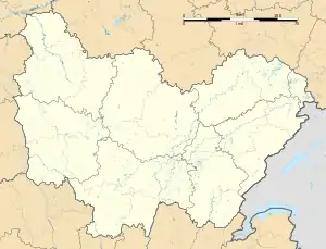 Fougerolles | |
| Coordinates: 47°53′10″N 6°24′12″E / 47.8861°N 6.4033°E | |
| Country | France |
| Region | Bourgogne-Franche-Comté |
| Department | Haute-Saône |
| Arrondissement | Lure |
| Canton | Saint-Loup-sur-Semouse |
| Commune | Fougerolles-Saint-Valbert |
| Area 1 | 51.12 km2 (19.74 sq mi) |
| Population (2019)[1] | 3,559 |
| • Density | 70/km2 (180/sq mi) |
| Time zone | UTC+01:00 (CET) |
| • Summer (DST) | UTC+02:00 (CEST) |
| Postal code | 70220 |
| Elevation | 276–569 m (906–1,867 ft) |
| 1 French Land Register data, which excludes lakes, ponds, glaciers > 1 km2 (0.386 sq mi or 247 acres) and river estuaries. | |
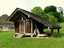
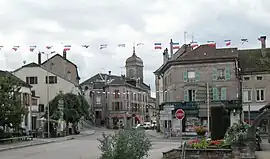
Fougerolles (French pronunciation: [fuʒʁɔl]) is a former commune in the Haute-Saône department in the region of Bourgogne-Franche-Comté in eastern France. On 1 January 2019, it was merged into the new commune Fougerolles-Saint-Valbert.[2] It is known for its kirsch and griottines.
Geography
Fougerolles is a fairly large town of 5112 hectares, making it the largest municipality of Haute-Saône after Champlitte. It borders the Lorraine region.
The city is bisected by the river Combeauté, which descends from the neighbouring commune of Le Val-d'Ajol.
See also
References
- ↑ Téléchargement du fichier d'ensemble des populations légales en 2019, INSEE
- ↑ Arrêté préfectoral 25 September 2018 (in French)
Wikimedia Commons has media related to Fougerolles (Haute-Saône).
This article is issued from Wikipedia. The text is licensed under Creative Commons - Attribution - Sharealike. Additional terms may apply for the media files.