Flora | |
|---|---|
 Flora Location within the state of Louisiana | |
| Coordinates: 31°36′45″N 93°5′52″W / 31.61250°N 93.09778°W | |
| Country | United States |
| State | Louisiana |
| Parish | Natchitoches |
| Elevation | 115 ft (35 m) |
| Time zone | UTC-6 (Central (CST)) |
| • Summer (DST) | UTC-5 (CDT) |
| ZIP code | 71428[2] |
| GNIS feature ID | 547366[1] |
Flora is an unincorporated community in Natchitoches Parish, Louisiana, United States. It is located near the intersection of Louisiana highways 120 and 478, south of Natchitoches.
The community is part of the Natchitoches Micropolitan Statistical Area.
References
- 1 2 "Flora, Louisiana". Geographic Names Information System. United States Geological Survey, United States Department of the Interior.
- ↑ "Flora ZIP Code". zipdatamaps.com. 2022. Retrieved November 30, 2022.
Municipalities and communities of Natchitoches Parish, Louisiana, United States | ||
|---|---|---|
| City | 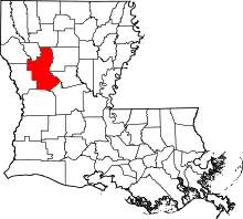 | |
| Town | ||
| Villages | ||
| CDPs | ||
| Other communities | ||
| Footnotes | ‡This populated place also has portions in an adjacent county or counties | |
This article is issued from Wikipedia. The text is licensed under Creative Commons - Attribution - Sharealike. Additional terms may apply for the media files.