Ἠμαθία Emathia | |
|---|---|
.svg.png.webp) The map shows modern Greek Macedonia, which closely approximates the last independent Kingdom of Macedon, and also approximates Strabo's Emathia at its greatest extent. It was renamed to Macedonia by its kings. What is different today is the "Central Macedonian Plain." It did not exist when Pella became the capital city of Macedonia. Pella was situated on an extension of the Thermaic Gulf, which filled in during classical and Hellenistic times to form first a lake and then the plain. The plain is almost entirely modern, currently being part of the Axios Delta National Park. Ancient Pella in ancient Emathia are bronze-age in date. Original Emathia extended up the right bank of the Axios through the highlands of Mount Paiko. Today's Imathia revitalizes the geopolitical concept, but does not match it. |
Emathia (Greek: Ἠμαθία) in ancient times was a geopolitical toponym, although no doubt based on a type of terrain prevalent in the region at the time. The toponym comprised different territories at different times, expanding from a base in the lower Axios River valley to include all of what was renamed to Macedonia.
Emathia initially was the region of the Macedonian capital, Pella, also of the capital of the Macedonian League, Beroia. In portraying these poleis moderns often based and still base their conclusions upon the modern map. Core samples and radiocarbon dating confirm that 19th and early 20th century literary analyses oftem had not taken into consideration changes in the terrain and the latest available archaeological data. Pella was not a late classical or Hellenistic settlement, although rendered into a legitimate polis by Philip II. Mycenaean surface sherds support at least a Bronze-age provenience, or close to it.
Moreover, Pella until quite late in the classical period had been a port city of the Thermaic Gulf. Subsequently its estuary became a lake until it was dispensed with by agriculturalists of the 20th century, with the Loudias River as a remnant. Consequently the courses of modern rivers there, as well as the alluvial area, now called "the Central Macedonian Plain," are modern and cannot be used to elucidate the details presented by the literary sources.
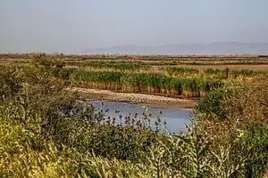
Today most of the C. Macedonian Plain is occupied by the Axios Delta National Park, mainly a collection of wetlands. Modern Imathia, etymologically from the same ancient word, is a new creation of modern Greece, as is modern Macedonia.
Localization
History of the terrain
Subsidence and aggradation in the region
The Aegean Sea Plate undergoing subsidence because of back-arc extension behind the Hellenic arc, the Aegean Sea is a classic example of drowned terrain: islands fronted by steep cliffs formed from mountain-tops, submergent coastlines with long estuaries formed by flooding from the sea. Acting contrary to the submergence is aggradation. Drowned rivers dump their sediment into their new estuaries creating river deltas. The deltas eventually combine to form alluvuial shelves and valleys, which, in the Aegean, typically became agricultural areas.
Over any period, an aggraded shoreline is the result of an equilibrium between subsidence and aggradation. Subsidence pushed the coastline inland; aggradation brings it out. The equilibrium may be cyclical, or it may trend in one direction.
Core studies in the C. Macedonian Plain compared with core studies from the whole Mediterranean have established that throughout the Aegean the rate of subsidence is on the average a little less than a metre per thousand years, which expresses itself as a rise in sea level to an observer at the surface.[1] Bintliff calls this a "eustatic rise."
The shoreline at any isochron; that is a line on the basin wall every part of which has the same date, obviously depends on the configuration of the surface between the location of the foot of the core and the concurrent shoreline. The more core samples that are available, the better the geologist can detail the surface. All models retain an element of speculation. In the case of the C. Macedonian Plain, Bintliff combines geological data with historical sources to develop a brief history of shorelines there.
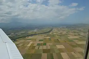
On the map, the Plain is the green area at the mouth of the Axios, today's Vardar River. Stretching across the Vardar, it extends E-W from Thessaloniki to Naoussa, a distance of about 73.42 km (45.62 mi), and N-S from Giannitsa to Vergina, about 34.53 km (21.46 mi). This is approximately the location of modern Imathia. The latter country, however, is distinguished from the ancient by not having been there. In its place was either a shallow estuary of the Thermaic Gulf, or a lake in a marsh, from prehistoric times to nearly the present. Ancient Emathia can only have been further north, but of course at the time when the name was changed, Emathia was all of Macedonia.
The white clay layer
Geologists of the 19th and 20th centuries formulated a number of geologic models of the central Macedonian plain, but few were as useful those based on the excavation of Nea Nikomedeia (NN), 1961, 1963-64, under the direction of Rodden and Grahame Clark.[2] NN is a Neolithic site at 40°36′15″N 22°15′54″E / 40.604156°N 22.264982°E, within the borders of Veria (Beroia), ancient capital of the Macedonian League, at the SW edge of the Plain.[lower-alpha 1]
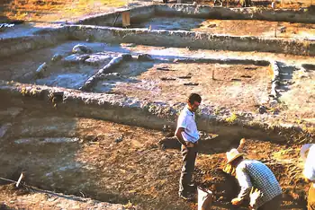
The mound of NN rose to a height of 3.5 m (11 ft) over an undisturbed subsoil layer of "white carbonate silt," with a disturbed portion of it rising another 0.5 m (1.6 ft).[3] The silt was classified by the excavators as lacustrine.[4] It was pollen-free.[5] Although it had accumulated under a lake, it was high and dry when the settlers built on it.[6]
This same layer was found at the bottom of an excavated drainage ditch 100 m to the SW, the layer's surface being at 7 m above current sea level.[3] NN seems to have been constructed on a mound of it. The layer in the ditch, however, represents ground level.
In fact the worldwide graph of sea level versus millenia bp shows a slope approximating a straight line at a steep angle until about 8000 bp, when it breaks, becomes shallow, and at about 6000 bp ceases to show subsidence, except for a dampened sinusoidal curve excursing cyclically above and below sea level. This fluctuation explains why the white layer appears above sea level. Currently there is no subsidence, explaining why aggradation has the upper hand. The flood basins are all full of silt, extending the shorelines outward.[7]
In 1965 a core, subsequently named GIANNITB, taken by Syte Bottema from the central area of the alluvium 7.5 km (4.7 mi) to the NW along a line to Gianitsa,[lower-alpha 2] revealed a physically similar white clay layer, believed to be of the same surface, at a depth of 12.52 m below the current sea level.[5] The bottom layer is described as being between 12.3900 m and 12.6500 m, consisting of "light-grey, marly clay."[8]
There is dating available on NN.[lower-alpha 3] The earliest settlement there, termed "the Early Neolithic" (EN), is dated 5500-5300 BC based on C-14 dates,[9] which, allowing 1950 for the AD time,[lower-alpha 4] would be 7450-7250 BP, the 8th millenium BP. A subsequent layer of detritus suggests an abandonment followed by a "Late Neolithic" reoccupation during which the ditch was dug.[9] The EN, being directly on the white layer, places the layer at settlement in the 8th millenium BP.
There is a problem with applying the general rate of subsidence to GIANNITB. According to it, the whole layer should be dated to the 13 millenium BP. At NN, it is dated to the 8th. Obviously, the standard rate cannot apply to the core if the layer at both places really is the same.
The lakeside cliff hypothesis
Having perceived the contradiction, and realizing the need to calibrate the plot of core meters[lower-alpha 5] versus BP dates; that is, to associate points within the plot with known data, Bottema acquired two carbon dates from material in the core, one from 6.525 m, and one from 9.950 m.[10] Very likely, both were done in the same year, 1965.
The 6.525 m date was 6590 ± 110 BP, which falls into the 6th millennium within the layer 6.58-6.8 m, described as "blue-grey clay," with an average depth of 6.69 m. The 9.950 m date was 7.27 ± 70 BP, which falls into the 8th millennium within the layer 9.74-10.91, described as "grey or blue-grey clay + shell fragments," with an average depth of 10.325 m. As it turns out, a number of weak points would develop in Bottema's interpretation of the core. He was so certain of his calibration of the carbon dates that he used BP, but that use was one of the first things questioned. Also, was the layer to be considered 9th or 10th millenium? And finally, was not the grey clay part of the white layer, which was supposed to be below 12.52 m?
In addition to the qualitative information such as plant and soil type, the core is a quantitative record of depth versus time period, which can be graphed in a Cartesian coordinate system with depth in the y direction and time in millennia (mill) in the x direction. The slope of the line at any point is the sedimentation rate in meters per millenium (m/mill.).
The graph of this core has only two known slopes, one of 6.525/6.59=0.99 m/mill, very nearly the standard subsidence rate of 1. At 6.525 the slope changes, with the new slope applying from 6.525 m to the end, 12.52 m. The known point is (9.950 m, 7.27 mill.). Δy/Δx from the previous point is 5.04 m/mill., a sedimentation rate far above standard, filling in the core much faster. The total mill. at 12.52 m is 7.778, within 8 mill., instead of the projected standard 13.
The problem seems solved except for one thing. Bottema's study of the pollen led him to assert that at the beginning of settlement at NN the sea level was 6-9 m below present (and not 12.52 m).
The tilted layer hypothesis
The prehistoric plain
Bintliff's reconstruction of the early Plain of Central Macedonia is as follows. The region derives ultimately from a calcic lake in a subsiding region during the Pliocene (5.33-2.58 Mya). The white, calcareous layer crystallized out of solution and was deposited over the bottom in a layer about 1 m thick. The phase lasted through the mid-Pleistocene (1.25-0.7 Myr).
In the Late Pleistocene (129,000-11700 ya) through the Early Holocene (11650-8200 bp), the lake dried up, exposing the white layer, from which weathering removed the pollen. This is the time when the white layer was probably continuous and simultaneous, with no detritus over it, at NN. Two m of alluvium at the core, however, indicate a contemporaneous slope of the layer between NN and there. The sea level was 6-9 m bp. At the C-14 date of 7270 bp the plain would have appeared as a dry, bright surface with a mound at the future NN. There were none yet to settle it.
Evidence of the Giannitsa core
The Giannitsa core's validation by carbon dating of the dates and sequences of sedimentary events in the central Macedonian plain from the 8th millenium made possible the credible reconstruction of shorelines there. Bintliff offers four, which he combines with the literary and archaeological evidence to chronicle the successive occupation of the plain and the rise of Macedon in it. Before the Neolithic, it was not settled, and not permanently occupied. One of the characteristics of the Neolithic is first-time permanent settlement. Sometimes it begins in the Mesolithic, but there is no evidence of that here. The settlers, whoever they were, began on unoccupied land.
Testimony of the sources
Earliest known name of Paeonia
Polybius (23.10.4) mentions that Emathia was earliest called Paeonia and Strabo (frg 7.38) that Paeonia was extended to Pieria and Pelagonia. According to N. G. L. Hammond,[11] the references are related to Bronze Age period before the Trojan War.
Under the name of Emathia
Homer,[12] who makes no mention of Macedonia, places Emathia as a region next to Pieria.
but Hera darted down and left the peak of Olympus; on Pieria she stepped and lovely Emathia, and sped over the snowy mountains of the Thracian horsemen, even over their topmost peaks, nor grazed she the ground with her feet; and from Athos she stepped upon the billowy sea, and so came to Lemnos, the city of godlike Thoas
The Homeric name was renewed mainly in Roman times and Ptolemy mentions some cities of Emathia. In Nonnus, Dionysiaca 48.6 Typhoeus having stripped the mountains of Emathia, he cast the rocky missiles at Dionysus. In Ovid, Metamorphoses 5.313 the daughters of Pierus say: "we grant Emathia's plains, to where uprise Paeonia's peaks of snow".[13]
The change to Macedonia
The Emathian or Emathius dux is a frequently used name by Latin poets for Alexander the Great, as in Milton, the Emathian conqueror. Strabo relates that "what is now called Macedonia was in earlier times called Emathia"[14] but since Homer, the earliest source considers Emathia only a region next to Pieria, Strabo's reference should be interpreted in the Roman era context of Emathia's name reviving. The same stands for Latin writers[15] who name Thessaly as Emathia; the Roman province of Macedonia included Thessaly. In 12.462 of Metamorphoses, an Emathian named Halesus is killed by the centaur Latreus and in Catullus 64. 324, Peleus is Emathiae tutamen (protector).
Etymology
Folk-etymologies
Emathia was named after the Samothracian king Emathion and not after the local Emathus.
Greek terrain etymology
The etymology of the name is of Homeric Greek origin - ‘amathos’= sandy soil, opp. to sea-sand (psámathos = ψάμαθος); in plural the links or dunes by the sea, [compare êmathóeis = ἠμαθόεις/ἠμᾰθόεις (masc.), ēmathóessa = ἠμαθόεσσα (fem.), ēmathóen = ἠμαθόεν (neut.) epic for amathóeis/ámathos = ἀμᾰθόεις ἄμαθος[16] and êmathoessa (see above)[17] 'sandy', i. e. the coastal, sandy/swampy land around Axius river, in contrast to mountainous Macedonia, probably also intended as 'laying large land' (cf. PIE *mē-2, *m-e-t- 'to mow, to reap').[18]
Towns
The most important towns of Emathia were:
Alexander the Great with settlers from this area founded Emathia in Syria.
Notes
- ↑ Nea Nikomedeia village is not actually in urban Veria, nor is the site actually in urban Nea Nikomedeia, as enlargement of the maps will show.
- ↑ The core is so named because Bottema selected it to be from the bed of filled Lake Giannitsa, or Lake Loudas, agricultural land when he took the core. It was published by him in 1976, so it is referenced in the literature as Giannitsa 1976, or Giannitsa Pollen Core, as Bottema was primarily interested in its pollen. The location is 40°40′00″N 22°19′00″E / 40.666667°N 22.316667°E. Actually, this location is more nearly 8 km from the archaeological site.
- ↑ Dates taken at the NN site are not to be confused with dates taken at the core, even though they might all reference the same Neolithic events.
- ↑ In the coded terminology of carbon dating, bp is before present, BP is calibrated before present, bc is the calender form of bp, BC is the calendar form of BP. In these archaeological sources, BC is almost never simple Before Christ and is therefore not replaceable by Before the Christian Era. Before present also is not that, but is before 1950, which for technical reasons replaces the calendar Anno Domini time. No matter what the current year, 1950 must be used in the conversion calculation from bp to BC. In that year, the amount of radioactive carbon in the atmosphere changed.
- ↑ A core does not distinguish between subsidence rate and aggradation rate. Bintliff uses just sedimentation rate. In periods of high subsidence this will be the subsidence rate, and in periods of high aggradation, this will be the aggradation rate.
Citations
- ↑ Bintliff 1976, p. 246, Figure 5a
- ↑ Rodden 1965, p. 83
- 1 2 Bintliff 1976, p. 244, Figure 3
- ↑ Bintliff 1976, p. 246
- 1 2 Bintliff 1976, p. 245
- ↑ Bintliff 1976, p. 247
- ↑ Bintliff 1976, p. 246, Figure 5b
- ↑ "Bottema, Sytze (2010): Lithology of sediment core GIANNITB, Giannitsa, Greece". PANGAEA. Retrieved 11 November 2023.
- 1 2 Bintliff 1976, p. 241
- ↑ "Bottema, Sytze (2010): Age determination of sediment core GIANNITB, Giannitsa, Greece". PANGAEA. Retrieved 14 November 2023.
- ↑ Prehistory of Macedonia, i. 418 n. 2
- ↑ Iliad 14.226
- ↑ The nine Muses and the nine Magpipes
- ↑ Strab.Frag.7.11
- ↑ Lucan (1. 1, 6. 360, 7. 166)
- ↑ Liddell–Scott–Jones amathos
- ↑ Pulon êmathoenta – Odyssey 1.93
- ↑ Pokorny Pokorny's dictionary
Citation bibliography
- Bintliff, John (1976). "The Plain of Western Macedonia and the Neolithic Site of Nea Nikomedeia". Proceedings of the Prehistoric Society. 42: 241–262.
- Finkelberg, Margalit (2012). "Emathia". The Homer Encyclopedia. Blackwell. doi:10.1002/9781444350302.wbhe0413. ISBN 978-1-4051-7768-9.
- Hammond, N GL (1997). "The location of Aegeae". The Journal of Hellenic Studies. 117: 177–179. doi:10.2307/632555. ISSN 0075-4269.
- Hatzopoulos, M.B. (2004). "Makedonia". In Hansen, M.H.; Nielsen, T.H. (eds.). An Inventory of Archaic and Classical Poleis (PDF). Oxford: Oxford University Press.
- Rodden, Robert J. (1965). "An Early Neolithic Village in Greece". Scientific American. 212 (4): 82–93.
- Smith, William, ed. (1854). "Emathia". Dictionary of Greek and Roman Geography. London: John Murray.
- Yiouni, Paraskevi (1992). The Pottery from Nea Nikomedeia in its Balkan Context (PhD thesis). University of London.
External links
![]() Media related to Emathia at Wikimedia Commons
Media related to Emathia at Wikimedia Commons