Eddington, Pennsylvania | |
|---|---|
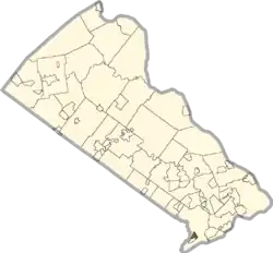 Location of Eddington within Bucks County | |
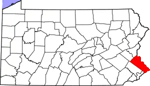
 Eddington Location of Eddington within Pennsylvania | |
| Coordinates: 40°05′04″N 74°56′42″W / 40.08444°N 74.94500°W | |
| Country | United States |
| State | Pennsylvania |
| County | Bucks |
| Township | Bensalem |
| Area | |
| • Total | 0.55 sq mi (1.43 km2) |
| • Land | 0.55 sq mi (1.43 km2) |
| • Water | 0.00 sq mi (0.00 km2) |
| Elevation | 66 ft (20 m) |
| Population | |
| • Total | 1,996 |
| • Density | 3,609.40/sq mi (1,393.19/km2) |
| Time zone | UTC-5 (Eastern (EST)) |
| • Summer (DST) | UTC-4 (EDT) |
| ZIP code | 19020 |
| Area code(s) | 215, 267 and 445 |
| GNIS feature ID | 1173981[3] |
Eddington is a census-designated place located in Bucks County, Pennsylvania, United States. The community was part of Cornwells Heights-Eddington, which was split into two separate CDPs. As of the 2010 census, the population was 1,906. The community is served by the Eddington station along SEPTA Regional Rail's Trenton Line.[4]
Demographics
| Census | Pop. | Note | %± |
|---|---|---|---|
| 2020 | 1,996 | — | |
| U.S. Decennial Census[5] | |||
See also
References
- ↑ "ArcGIS REST Services Directory". United States Census Bureau. Retrieved October 12, 2022.
- ↑ "Census Population API". United States Census Bureau. Retrieved October 12, 2022.
- ↑ "Eddington". Geographic Names Information System. United States Geological Survey, United States Department of the Interior.
- ↑ SEPTA Official Transit & Street Map Suburban (PDF) (Map). SEPTA. Retrieved May 2, 2016.
- ↑ "Census of Population and Housing". Census.gov. Retrieved June 4, 2016.
External links
Founded 1682 | |||||||||||
| Communities | |||||||||||
| Education | |||||||||||
| Government | |||||||||||
| Attractions/ Landmarks |
| ||||||||||
| Transportation |
| ||||||||||
| Related | |||||||||||
This article is issued from Wikipedia. The text is licensed under Creative Commons - Attribution - Sharealike. Additional terms may apply for the media files.