Desoto Acres, Florida | |
|---|---|
 Desoto Acres  Desoto Acres | |
| Coordinates: 27°22′54″N 82°31′0″W / 27.38167°N 82.51667°W | |
| Country | |
| State | Florida |
| County | Sarasota |
| Area | |
| • Total | 1.32 sq mi (3.41 km2) |
| • Land | 1.31 sq mi (3.38 km2) |
| • Water | 0.01 sq mi (0.03 km2) |
| Elevation | 38 ft (12 m) |
| Population (2020) | |
| • Total | 720 |
| • Density | 550.88/sq mi (212.71/km2) |
| Time zone | UTC-5 (Eastern (EST)) |
| • Summer (DST) | UTC-4 (EDT) |
| ZIP Codes | 34234, 34243 (Sarasota) |
| Area code | 941 |
| FIPS code | 12-17273 |
| GNIS feature ID | 2805173[2] |
Desoto Acres is a census-designated place (CDP) in northwestern Sarasota County, Florida, United States. It is 4 miles (6 km) north of downtown Sarasota and is bordered to the east by Desoto Lakes.
Desoto Acres was first listed as a CDP prior to the 2020 census.
Demographics
| Census | Pop. | Note | %± |
|---|---|---|---|
| 2020 | 720 | — | |
| U.S. Decennial Census[3] | |||
As of the 2020 census,[4] Desoto Acres had a population of 720 with a total of 296 households. The median household income was $68,986. 30.3% of the population 25 years and older had a Bachelor's degree or higher. The CDP had an employment rate of 73.1%. 10.9% of the population lived without healthcare coverage.
References
- ↑ "2020 U.S. Gazetteer Files". United States Census Bureau. Retrieved October 31, 2021.
- 1 2 "Desoto Acres Census Designated Place". Geographic Names Information System. United States Geological Survey, United States Department of the Interior.
- ↑ "Census of Population and Housing". Census.gov. Retrieved June 4, 2016.
- ↑ "Desoto Acres CDP, Florida". www.census.gov. US Census Bureau. Retrieved April 13, 2023.
Municipalities and communities of Sarasota County, Florida, United States | ||
|---|---|---|
| Cities | 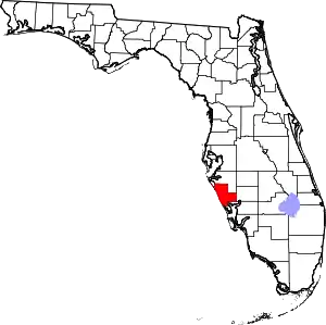 | |
| Town | ||
| CDPs |
| |
| Unincorporated communities | ||
| Footnotes | †This populated place also has portions within the city limits of North Port, ‡This populated place also has portions in an adjacent county or counties | |
This article is issued from Wikipedia. The text is licensed under Creative Commons - Attribution - Sharealike. Additional terms may apply for the media files.