 Shown within Romania | |
| Location | Cetăţuia,[1] Cugir, Alba, Romania |
|---|---|
| Coordinates | 45°49′39″N 23°21′56″E / 45.8276°N 23.3655°E |
| Altitude | 480 m (1,575 ft) |
| Site notes | |
| Condition | Ruined |
| Reference no. | AB-I-s-B-00030 [1] |
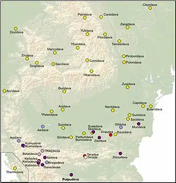
It was a Dacian fortified town.
References
- 1 2 "National Register of Historic Monuments in Romania, Alba County" (PDF). www.inmi.ro. Archived from the original (PDF) on 16 March 2012. Retrieved 16 October 2012.
| Tribes (List) | |||||||||||||||||
|---|---|---|---|---|---|---|---|---|---|---|---|---|---|---|---|---|---|
| Kings |
| ||||||||||||||||
| |||||||||||||||||
Wars with the Roman Empire |
| ||||||||||||||||
| Roman Dacia / Free Dacians |
| ||||||||||||||||
| Research |
| ||||||||||||||||
| |||||||||||||||||
This article is issued from Wikipedia. The text is licensed under Creative Commons - Attribution - Sharealike. Additional terms may apply for the media files.