| Crow Creek Tributary to Uwharrie River | |
|---|---|
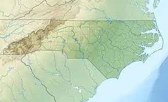 Location of Crow Creek mouth  Crow Creek (Uwharrie River tributary) (the United States) | |
| Location | |
| Country | United States |
| State | North Carolina |
| County | Randolph Montgomery |
| Physical characteristics | |
| Source | Laniers Creek divide |
| • location | about 1 mile west of New Hope, North Carolina |
| • coordinates | 35°33′09″N 080°02′12″W / 35.55250°N 80.03667°W[1] |
| • elevation | 665 ft (203 m)[2] |
| Mouth | Uwharrie River |
• location | about 0.75 miles northeast of Coggins Mine, North Carolina |
• coordinates | 35°29′46″N 080°00′16″W / 35.49611°N 80.00444°W[1] |
• elevation | 351 ft (107 m)[2] |
| Length | 5.22 mi (8.40 km)[3] |
| Basin size | 10.14 square miles (26.3 km2)[4] |
| Discharge | |
| • location | Uwharrie River |
| • average | 12.02 cu ft/s (0.340 m3/s) at mouth with Uwharrie River[4] |
| Basin features | |
| Progression | Uwharrie River → Pee Dee River → Winyah Bay → Atlantic Ocean |
| River system | Pee Dee River |
| Tributaries | |
| • left | unnamed tributaries |
| • right | Wallace Branch Big Creek |
| Bridges | Hogan Farm Trail, Crow Creek Road, Bells Grove Road, New Hope Road |
Crow Creek is a 5.22 mi (8.40 km) long 3rd order tributary to the Uwharrie River in Montgomery County, North Carolina.
Course
Crow Creek rises on the Laniers Creek divide in Randolph County about 1 mile west of New Hope, North Carolina. Crow Creek then flows southeast into Montgomery County to join the Uwharrie River about 0.75 miles northeast of Coggins Mine.[2]
Watershed
Crow Creek drains 10.14 square miles (26.3 km2) of area, receives about 47.4 in/year of precipitation, has a wetness index of 377.59 and is about 65% forested.[4]
See also
References
- 1 2 "GNIS Detail - Crow Creek". geonames.usgs.gov. US Geological Survey. Retrieved 15 September 2020.
- 1 2 3 "Crow Creek Topo Map in Montgomery". TopoZone. Locality, LLC. Retrieved 15 September 2020.
- ↑ "ArcGIS Web Application". epa.maps.arcgis.com. US EPA. Retrieved 15 September 2020.
- 1 2 3 "Crow Creek Watershed Report". US EPA Geoviewer. US EPA. Retrieved 15 September 2020.
This article is issued from Wikipedia. The text is licensed under Creative Commons - Attribution - Sharealike. Additional terms may apply for the media files.