| Crooked Creek | |
|---|---|
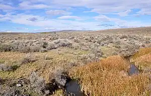 Crooked Creek south of Burns Junction | |
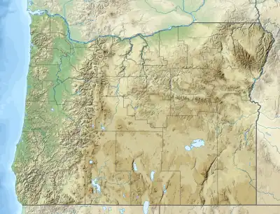 Location of the mouth of Crooked Creek in Oregon | |
| Location | |
| Country | United States |
| State | Oregon |
| County | Malheur |
| Physical characteristics | |
| Source | Crooked Creek Springs |
| • location | Malheur County |
| • coordinates | 42°40′32″N 117°54′33″W / 42.67556°N 117.90917°W[1] |
| • elevation | 3,921 ft (1,195 m)[2] |
| Mouth | Owyhee River |
• location | 4.5 miles (7.2 km) northwest of Rome |
• coordinates | 42°52′57″N 117°41′52″W / 42.88250°N 117.69778°W[1] |
• elevation | 3,343 ft (1,019 m)[1] |
| Length | 51 mi (82 km)[3] |
| Basin size | 1,340 sq mi (3,500 km2)[4] |
Crooked Creek is a 51-mile (82 km) tributary of the Owyhee River in the U.S. state of Oregon.[3] The source of Crooked Creek is at an elevation of 3,921 feet (1,195 m) at Crooked Creek Spring,[2] while the mouth is at an elevation of 3,343 feet (1,019 m) near Rome.[1] Crooked Creek has a 1,340-square-mile (3,500 km2) watershed.[4]
See also
References
- 1 2 3 4 "Crooked Creek". Geographic Names Information System (GNIS). United States Geological Survey (USGS). November 28, 1980. Retrieved November 1, 2010.
- 1 2 Source elevation derived from Google Earth search using GNIS source coordinates.
- 1 2 "Vmap0". GIS-Lab. Retrieved September 3, 2010.
- 1 2 "Oregon Hydrologic Units". United States Geological Survey. 1996. Retrieved September 3, 2010.
This article is issued from Wikipedia. The text is licensed under Creative Commons - Attribution - Sharealike. Additional terms may apply for the media files.